Bryan Norcross: Hurricane Francine to make landfall on the Louisiana coast today
Hurricane Francine is bearing down on the Louisiana coast, forecast to reach Category 2 intensity before landfall.

Bryan Norcross spots eye of Hurricane Francine as storm nears Louisiana landfall
FOX Weather Hurricane Specialist Bryan Norcross talks about the future of Hurricane Francine as it moves closer to landfall in Louisiana.
Updated at 10:30 a.m. ET on Wednesday, Sept. 11, 2024
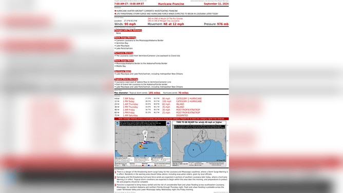
Hurricane Francine is bearing down on the Louisiana coast. Bands of tropical rain are already ashore. Winds will be increasing through the day. Gulf water levels at the coast will also increase, even though the tide is going out. High tide was overnight and low tide will come early this evening, but the winds around Francine will push seawater against the normal tide.
Everyone in southeastern Louisiana should be in their safe spot by afternoon where they're going to ride out the storm. Think about where your car is parked – find a spot away from trees and on high ground if you don't have a garage. Get gas. Prepare for the power to go out for days.
Hurricane Francine to bring life-threatening storm surge to Louisiana later today.
(Bryan Norcross / National Hurricane Center)
Francine's core consolidated last night and winds increased to 90 mph. The upper-level winds are becoming increasingly hostile now, so that should keep the hurricane from dramatically intensifying, though it could still get a bit stronger. The current forecast is for Francine to reach Category 2 before landfall.
The National Hurricane Center has been forecasting a water rise of up to 10 feet above normal high tide on the central part of the southern Louisiana coast. It's not likely to get that high because it looks like Francine will make landfall at closer to low tide, so take about 2 feet off that number. But it's obviously still a life-threatening situation on the Gulf coast and around Lake Pontchartrain just north of New Orleans.
The city is well protected by the massive Hurricane and Storm Damage Risk Reduction system, but now areas outside of the levees.
The Storm Surge Warning indicates that life-threatening storm surge is possible in some part of the warning zone. Because you are under a warning, does not mean that you will get the worst conditions for sure. It means that you could, so you have to prepare for the possibility.
Hurricane Warnings extend well inland, indicating areas where extreme winds are forecast. The New Orleans area is under a Hurricane Watch, meaning hurricane-force winds are possible, especially in the western metro.
A storm surge will also impact the Mississippi coast, and water will likely rise as far east as Alabama.
Rainfall adding up to 4 to 8 inches with some areas seeing a foot will cover a wide area from the Gulf Coast across Mississippi and into the Mid-South. The ground is saturated from last week's rain which will enhance the flood threat. The National Weather Service has a level 3 out of 4 flood alert in effect.
It's critical that everyone watch for and pay attention to alerts issued for their area including information and instructions from local officials.
Francine will die out in the Mid-South or the lower Midwest by the end of the week, but it will take some time for the rainwater to drain to the Gulf. That means the flood threat might not go away when the storm passes.
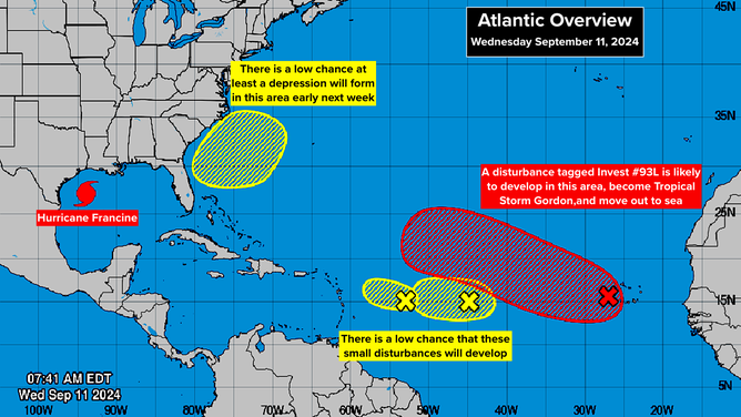
New invest likely to become Tropical Storm Gordon.
(Bryan Norcross / National Hurricane Center)
Far out in the Atlantic, the National Hurricane Center is still making note of 3 systems. The two left systems have low chances of developing, but residents in the islands should stay aware, just in case.
The system to the east is expected to develop into a tropical storm, however. An existing Atlantic disturbance combined with a second disturbance that moved off Africa are forecast to organize into a system that will probably be named Gordon. The storm is likely to move north into the open Atlantic.
Off the southeast coast, the front that's been sitting across the northern Gulf and North Florida might trigger a low-pressure area offshore of Georgia and the Carolinas. Systems like this can become tropical over the Gulf Stream, so we'll keep an eye out for that early next week.