Bryan Norcross: Francine brings flooding rains to the South as we watch some other areas in the Atlantic
Heavy rain has spread across Alabama. Gusty winds are still affecting the coastal areas, causing water along the Gulf coast and in the large lakes near New Orleans to be higher than normal. As the storm winds down, the moisture will remain across much of the South.

FOX Weather is your Hurricane HQ.
(FOX Weather)
Updated at 9:30 a.m. ET on Thursday, Sept. 12, 2024
Francine's center of circulation is slowly moving north through Mississippi. Winds have dropped below 40 mph, so it’s officially Tropical Depression Francine now.
Heavy rain has spread across Alabama. Gusty winds are still affecting the coastal areas, causing water along the Gulf coast and in the large lakes near New Orleans to be higher than normal. As the storm winds down, the moisture will remain across much of the South. Stay informed of local flood alerts that might be issued.
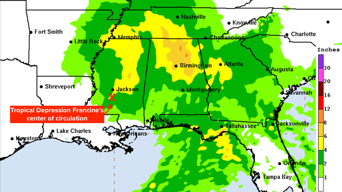
Rainfall forecast from now-Tropical Depression Francine.
(NOAA)
Francine made landfall late yesterday afternoon southwest of New Orleans as yet another storm that hugged the right side of the forecast cone. Even though strong upper winds were ripping at the storm, it was able to redevelop an intense northern eyewall just before landfall. Those tall thunderstorms wrapping around the north side of the circulation seemingly caught the strong upper-level winds, which dragged the system slightly farther east and closer to New Orleans.
The redeveloped eyewall passed over the western sections of metro New Orleans, including Metairie and Kenner. Rainfall amounts were up to 3 inches per hour, causing extremely dangerous flash flooding. Some flooding is still possible in southeastern Louisiana and the surrounding areas as the rainfall runs down through the rivers and streams into the Gulf.
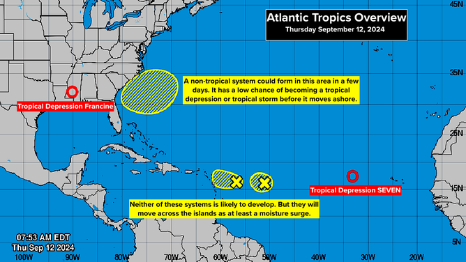
Several areas to watch in the Atlantic.
(National Hurricane Center)
In the Atlantic off the Southeast coast, there is an area to watch. In a few days, the frontal system that was draped over the northern Gulf, North Florida and into the Atlantic might develop into a non-tropical low-pressure system offshore of Georgia or the Carolinas. If the system lingers over the warm Gulf Stream, it could develop some tropical characteristics before it moves back toward the coast.
There is only a medium consensus in the computer forecast models that the non-tropical low-pressure system will develop. And there is even a lower chance that it will become tropical. The National Hurricane Center has the odds of the system becoming at least a tropical depression in the low category. But stay tuned, especially on the Carolina coast.
Far out in the Atlantic, Tropical Depression Seven is drifting toward the west. It's forecast to soon become Tropical Storm Gordon. There is no apparent threat to land from the system. It looks likely to drift for a while and then eventually turn north.
Closer to the Caribbean islands, there are two small systems on the map. The left one has been tagged Invest 94L. Neither of these disturbances are likely to develop. They are plowing into a very dry atmosphere. Still, they will likely increase the moisture over Puerto Rico and the surrounding northeastern Caribbean islands over the next few days. The National Hurricane Center has the odds of any development in the low range.
Nothing else seems in the offing for now. The Atlantic still appears to be in an odd state. Systems we would expect to develop, considering the extremely warm ocean water and apparently conducive atmosphere, don't organize as quickly or as robustly as they often do. It's a bit of a puzzle that will likely take time to resolve. We think we know many of the pieces, but we might not know all of them, and we certainly don't yet know how they fit together.