Bryan Norcross: Watching an area off the Southeast coast for possible development in a few days
The remnants of Francine create the risk of Flash Flooding over the weekend. The National Hurricane Center is monitoring an area offshore of Georgia and the Carolinas where the developing low could become somewhat tropical early next week.

FOX Weather is your Hurricane HQ.
(FOX Weather)
Updated at 10:30 a.m. ET on Friday, Sept. 13, 2024.
A frontal system extends from the remnants of Francine over Arkansas across north Florida to a developing non-tropical, low-pressure system off the Southeast coast. The National Hurricane Center is painting an area offshore of Georgia and the Carolinas where the developing low could become somewhat tropical early next week. Their odds of that happening are in the low category.
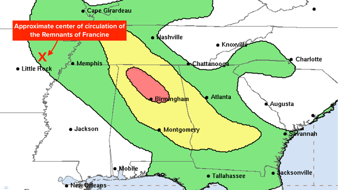
Risk of Flash Flooding due to remnants of Francine extends into the weekend
(NOAA / NOAA)
It's quite common for low pressure to develop along a front offshore of Georgia and the Carolinas. At this time of year, when the ocean water is very warm, those systems can take on tropical characteristics if they sit offshore long enough.
This developing low is forecast to eventually loop back onshore and into North Carolina next week. The only question is what form it will take and whether it will have a chance to develop into a tropical system. Everybody from South Carolina to coastal Virginia should plan to stay informed as the system evolves.
The remnants of Francine are spinning themselves out over western Arkansas. The moisture feed rotating into the circulation continues to arc from the Gulf across Georgia and Alabama and into the Midsouth.
The National Weather Service is forecasting a moderate chance of flash flooding to continue in Alabama, with periods of heavy rain in the other areas under that channel of tropical moisture. Stay aware of local alerts in the affected areas.
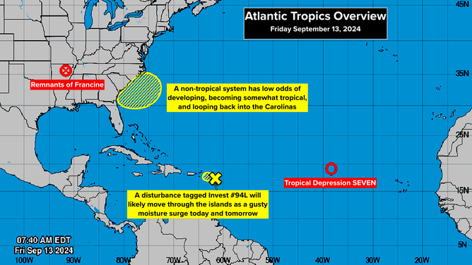
Three Areas to Watch in the Atlantic
(NOAA / NOAA)
Over the Northeast Caribbean, a small tenacious disturbance tagged Invest #94L is moving across the islands. It and a second disturbance right behind it will bring gusty downpours to Puerto Rico and the surrounding areas over the next couple of days. These systems are plowing into dry air, so development is not expected. But everybody in the northeast Caribbean should stay aware that periods of heavy rain are possible.
Far out in the Atlantic, Tropical Depression Seven is plodding to the west. The atmospheric conditions don't appear conducive for strengthening. This system looks most likely to dissipate or turn to the north. In any case, it's not forecast to affect land.
The situation with Tropical Depression Seven is indicative of what's been unusual in the east Atlantic this hurricane season. The depression is moving so slowly that it can't use its motion as part of the process of spinning up into a stronger system. And it's encountering unusually dry air.
It's all good, but it's weird. There will be a lot of discussion to try to fully understand the causes of the unusual atmospheric pattern this hurricane season.