Bryan Norcross: A new system is likely to develop off the Carolina coast
The atmospheric environment over the Caribbean and Gulf has been less hostile than over the eastern Atlantic. So, we'll stay aware.

FOX Weather is your Hurricane HQ.
(FOX Weather)
Updated Saturday 9:00 a.m. ET
A complicated weather pattern over the Southeast is looking more likely to generate a tropical-type depression or storm over the next few days. A front that runs from the remnants of Francine in the Midsouth across North Florida and into the Atlantic will be the catalyst for a low-pressure system to develop offshore of the Georgia coast.
Strong winds from the northeast and east meet a tropical flow from the south along the development zone, which helps create spin in the atmosphere.
The air will be squeezed between the developing low-pressure area and high pressure over eastern Canada. Winds will become quite brisk along the Carolina coast today as the system develops. Through tomorrow and into Monday, the computer forecast models generally show the low separating from the front and moving north and northwest toward North Carolina.

New Disturbance to Develop
(CIRA / RAAMB / FOX Weather)
When it becomes an independent system over the Gulf Stream waters, it will have an opportunity to develop into a depression or storm with tropical characteristics. If winds reach 40 mph in the circulation, which a number of the computer forecasts predict, it will get the name Helene.
The system may end up in a hybrid state – partially non-tropical and partially tropical. In that case, it will be designated a subtropical depression or named Subtropical Storm Helene, if the winds are strong enough.
Residents along the Carolina coast should be ready for an extended period of gusty winds, and nasty weather, which will peak on Monday on the current schedule. There is no indication at the current time that this system could turn into a hurricane, though we have seen that happen near the coast in the past.
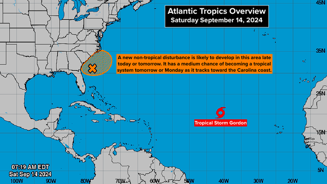
Atlantic Tropics Overview
(National Hurricane Center)
OUT IN THE ATLANTIC: Tropical Storm Gordon is drifting to the west in the open ocean. It is not expected to affect land.
It looks likely that this hurricane season is going to turn out very differently than was originally forecast, but the third part of the season is still to come. First, we start in the Gulf and near Florida. Second, we look in the eastern Atlantic. And third, we are back in the Gulf, near Florida, and in the Caribbean. That's on average, of course. This year, Hurricane Beryl broke that rule, but generally that's the case.
Hurricanes Ian, Michael, Sandy, and Wilma are examples of third-part-of-the-season storms.
I'm not saying that a storm like one of those will form, but the atmospheric environment over the Caribbean and Gulf has been less hostile than over the eastern Atlantic. So, we'll stay aware.