Bryan Norcross: Disturbance with tropical-storm-force winds off the Carolinas will make landfall today
It's a lopsided system with most of the bad weather north of the front that stretches through the broad center. The pressure contrast between the disturbance's low pressure and a broad high over New England is causing the air to be squeezed.
Bryan Norcross discusses the impacts of Potential Tropical Cyclone 8
FOX Weather Hurricane Specialist Bryan Norcross talks about the impacts being brought to the Carolina coast by Potential Tropical Cyclone Eight.
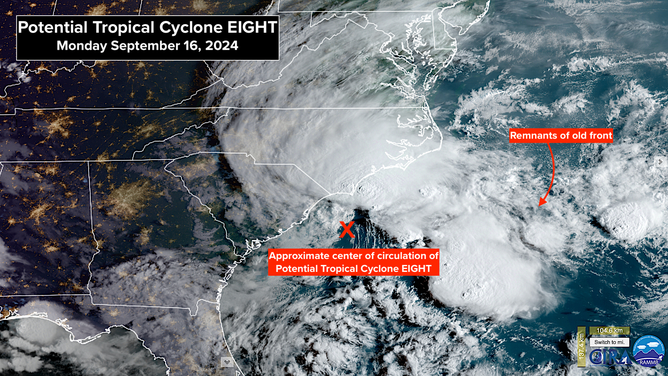
The non-tropical disturbance offshore of Myrtle Beach is close to forming into a tropical storm, but it's still involved with a front and is being stretched out by hostile upper winds. It's called Potential Tropical Cyclone EIGHT, which just means that it could still develop into a tropical system before it makes landfall later today.
Hurricane hunters measured winds well north of the center of circulation at 50 mph. If the system can organize over the warm Gulf Stream waters and fight off the hostile upper winds, it will be named Helene.
It's a lopsided system with most of the bad weather north of the front that stretches through the broad center. The pressure contrast between the disturbance's low pressure and a broad high over New England is causing the air to be squeezed. Like squeezing a toothpaste tube, the pressure difference accelerates the air. In this case, the focus of the channel of stronger winds is on North Carolina and the northern coast of South Carolina.
The persistent easterly flow will cause flooding in some areas along the coast around high tide from Cape Hatteras south, on the west side of Pamlico Sound, and up the Neuse River. The tides are unusually high this time of year as part of the astronomical cycle, which will add to the water rise. The storm surge forecast is for up to 3 feet above normal high tide in the affected areas.

The features of Potential Tropical Cyclone 8.
(FOX Weather)
There's already a flood threat from heavy rain inland in the Carolinas, where the onshore winds are pushing moisture ashore. Some areas are forecast to receive up to 6 inches more rain as the system tracks inland. The heaviest rain will fall to the right of the center's path.
Stay alert for local warnings from the National Weather Service. Inland flooding can be very dangerous in and around the streams and rivers in the Carolinas.
What's left of this disturbance, wannabe-Helene, will move inland and die out, but the moisture will spread north into the Mid-Atlantic and the Northeast.
ELSEWHERE IN THE ATLANTIC, Gordon is weak now, but it might regenerate farther north in the open Atlantic.
LOOKING AHEAD, long-range computer forecast models still indicate the possibility of a system developing in the western Caribbean and moving north in some fashion next week. There's nothing definitive or even a disturbance to look at yet. All possibilities are on the table, including nothing developing at all.
