Bryan Norcross: Carolina flood threat continues as the tropics go mostly quiet for now
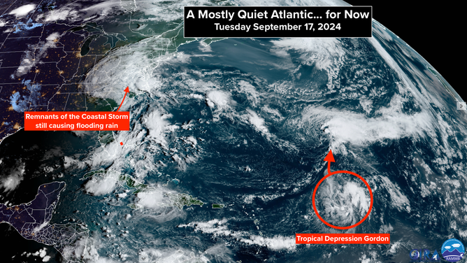
In the open Atlantic, Gordon is forecast to head north, strengthen back into a tropical storm, and eventually possibly a hurricane. It's no apparent threat to land.

FOX Weather is your Hurricane HQ.
(FOX Weather)
Updated at 10:30 a.m. ET on Tuesday, Sept. 17, 2024
The coastal storm tagged Potential Tropical Cyclone Eight is no more. It moved inland after dumping epic rainfall on southeastern North Carolina. The storm could never shed its attached fronts and form a tropical core over the warm Gulf Stream waters. It ran out of time. Still, winds gusted over 60 mph along the coast.
It was a tropical storm in reality, if not in name.

Satellite imagery shows a quieter Atlantic Basin for now.
( / NOAA)
A confluence of factors came together to produce such intense rainfall and strong winds. High pressure over New England squeezed the air into a channel aimed at North Carolina. At the same time, tropical air fed north. The front was the boundary between those two types of air mass, which fed into the mix-master, which was the low-pressure system. In the upper levels of the atmosphere, the steering currents were very light, and an upper-level disturbance enhanced thunderstorm development.
The slow-moving storm meant rain fell over the same areas for long periods of time. In Carolina Beach, North Carolina, near the coast, some 2 feet of rain came down just yesterday.
Now the moisture will spread north into the mid-Atlantic and Northeast over the next few days. The legacy of the storm is going to be the flooding rain. It will take a few days for all the rain that fell to drain down the streams, creeks and rivers into the Atlantic. There is still water over some streets and highways in eastern North Carolina.
In the open Atlantic, Gordon is forecast to head north, strengthen back into a tropical storm, and eventually possibly a hurricane. It's no apparent threat to land.
Down the road, nothing else is in the immediate offing. We'll watch the Caribbean next week. Long-range computer forecast models indicate that something might try to spin up, but there's nothing to look at right now.
Deeper dips in the jet stream begin to form this time of year, which can push fronts farther south and scoop Caribbean and southern-Gulf disturbances north. As we saw off the Carolinas, fronts can be the trigger that gets storms started.
The hostile conditions that have blanketed the Atlantic this season have had little effect over the Caribbean and the Gulf of Mexico. Now that we are heading toward the part of the season when systems are more likely to develop in that zone, there's no obvious reason why a "normal" hurricane season shouldn't resume … based on what we know.
The cause of the limited tropical activity over the Atlantic and, indeed, all of the tropical oceans is unclear. Is it a macro factor like climate change that has reached a tipping point? Or did the injection of massive amounts of water vapor into the stratosphere by the Hunga-Tonga volcano in 2022 dramatically disrupt the vertical temperature distribution in the atmosphere? Or is it a combination of those and other random factors that affect the weather patterns every day? There is much more to know.
Hurricanes are a fundamental part of how the Earth's atmospheric/oceanic system distributes heat around the planet. That system seems to have been disrupted. What that means isn't clear.