Bryan Norcross: Focusing on the western Caribbean for possible development next week
The National Hurricane Center is painting a potential development area over the western Caribbean where they are putting the odds of a tropical system developing over the next 7 days in the low category. Long-range computer forecasts indicated that the odds might increase late next week.

Tropical activity lurking in Atlantic could gradually shift into Gulf of Mexico
The FOX Forecast Center is closely monitoring what could become the Atlantic’s next named storm, potentially developing sooner rather than later. Attention will turn to the Caribbean late this weekend and into next week, as the atmospheric environment is expected to become increasingly favorable for tropical development.
UPDATED: Wednesday at 9 a.m. ET
Long-range computer forecast models continue to show the possibility of some kind of tropical development next week in the western Caribbean Sea. There is no consensus on where a potential system would most likely track or how strong it would be. Still, given the extreme amount of energy in the seawater offshore of Central America, systems that develop there can spin up quickly.
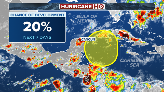
Area to Watch in Caribbean
(FOX Weather)
The National Hurricane Center is painting a potential development area over the western Caribbean where they are putting the odds of a tropical system developing over the next 7 days in the low category. Long-range computer forecasts indicated that the odds might increase late next week.
Over the next week, you'll probably be hearing a lot about the Central American Gyre or CAG. A gyre is simply a large rotating system. In this case, obviously, it's over Central America. Early in the season and then again late in the season, a large CAG low-pressure system often straddles Central America.
If the atmospheric environment is conducive to development, tropical systems can spin off from the large, rotating CAG into the Caribbean, the Gulf, or the Pacific Ocean.
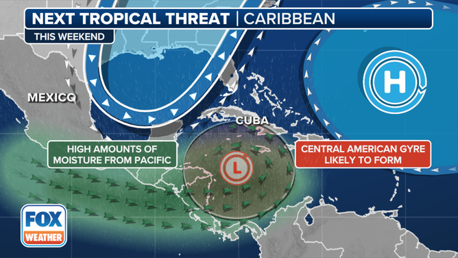
Systems that track to the north are grabbed by a dip in the jet stream. Systems that head west into Mexico, for example, are usually blocked by high pressure across the southern U.S. Because the overall weather pattern a week or more in advance is uncertain, it's impossible to know which way a system might go, if it were to develop. If the development was scheduled for Wednesday, say, but didn't happen till Thursday, the steering pattern could be completely different.
The bottom line is, don't look at any specific projections at this point. Just be aware that the long-range projection of the atmospheric pattern appears conducive for development next week.
IN THE OPEN ATLANTIC, the remnants of Tropical Storm Gordon are drifting to the north. Eventually, the system might encounter less-hostile conditions, and it could redevelop into a tropical storm. As long as the remnants are a trackable, identifiable entity, the redeveloped system will be named Gordon again.
LONG RANGE COMPUTER FORECASTS show a system moving off Africa into the Atlantic around the weekend. There's no indication that it would threaten land at this early stage.