Bryan Norcross exclusive analysis: Tropical system looking to slowly develop in the Caribbean next week
Gulf Coast states from Texas to Florida should stay informed ahead of potential tropical system development in the Caribbean or Gulf of Mexico next week.

FOX Weather is your Hurricane HQ.
(FOX Weather)
Updated at 10 a.m. ET on Thursday, Sept. 19, 2024
The consensus of the computer forecast models is that a tropical system will try to develop in the western Caribbean Sea or extreme southern Gulf of Mexico next week. Exactly when it develops, how strong it gets, and where it tracks are open questions. But a number of the long-range projections show a strong tropical storm or a hurricane in the Gulf by the end of the week.
The National Hurricane Center now has the odds of a tropical system developing over the next seven days in the medium range. If the computer-forecast trends continue, however, I expect the development chances to increase as the seven-day period encompasses all of next week.
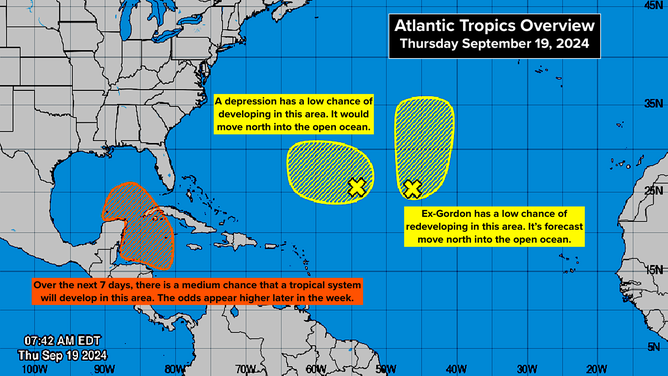
Tropical system to slowly develop in the Caribbean next week.
(National Hurricane Center)
Over the weekend, a large area of low pressure called the Central American Gyre (CAG) is forecast to slowly develop over the Central American landmass straddling from the Pacific to the Caribbean. This is a common feature in the latter part of a hurricane season.
At the same time, an unusually strong dip in the jet stream is forecast to plunge over Florida, pushing a front through the state. It's very unusual for a cold front to make it all the way south past the tip of the Florida Peninsula this early in the year. In this case, the air won't be cold, but eventually, it will be less humid if the forecasts are correct.
The jet-stream dip will bring hostile upper winds to the western Caribbean, prohibiting quick development. But after it moves east next week, a bubble of very conducive conditions is forecast in its wake, under which a lobe of the CAG could break off and develop.
After the process of developing a tropical disturbance begins, things get murky. The path the system takes is dependent on how quickly it intensifies and how the steering pattern to the north evolves. The consensus is that the system will eventually move north or northwest, but all outcomes are on the table and look slow to evolve.
High pressure behind the Florida cold front might initially block northward movement, but then a broad dip in the jet stream moving across the U.S. is coming along that could scoop the system north or northeast across the Gulf. It's all "might" and "could" at this point because we're talking about the end of next week and the following weekend.
None of the computer models we rely on are especially good at figuring out when a disturbance will form and especially when it will organize into a depression or a storm. Since the timing is so critical to the future track, we are left remembering the rule that forecasts for just developing or disorganized systems are subject to large errors and significant changes.
This system does not even count as disorganized. It hasn't even begun to exist.
There's nothing to do now except stay informed. The potential threat zone stretches from Texas to Florida. We're still in the heart of hurricane season, so an organized tropical system is not unexpected, and the western Caribbean and southern Gulf are always prime locations for tropical development in late September.
With the seawater holding extra energy this year, a system could spin up quickly, so plan to check the forecast over the weekend, although the development process looks most likely to begin next week.
Out in the open Atlantic, the remnants of Gordon might redevelop into a tropical depression or tropical storm before heading into the North Atlantic.
Another well-defined low-pressure area near ex-Gordon has a low chance of developing into at least a tropical depression before it heads north into the open ocean.
Over Africa, one or two disturbances are due to move off the continent into the Atlantic next week, farther south than most of the systems this year. There's nothing to watch right now, but they appear to be telling us that hurricane season is returning to something like a normal state for September.