Bryan Norcross exclusive analysis: Still watching for development in the Caribbean or Gulf next week
There's a good chance that an organized tropical depression or tropical storm will eventually form in the Caribbean or Gulf of Mexico next week.
Bryan Norcross goes into deeper analysis on tropical threat brewing in the Caribbean
The upper-level weather pattern is forecast to be conducive for tropical development over Central America and the surrounding waters next week.
Updated at 10 a.m. ET on Friday, Sept. 20, 2024.
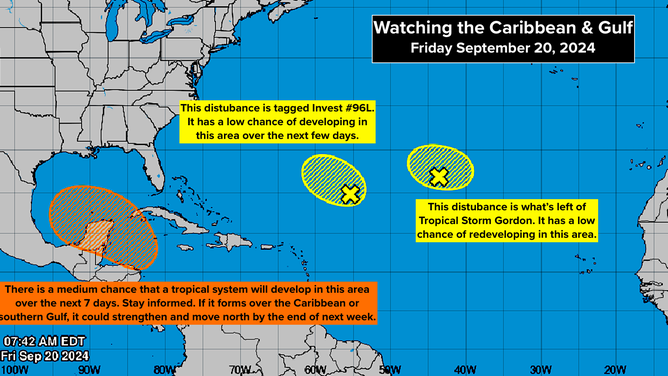
The upper-level weather pattern is forecast to be conducive for tropical development over Central America and the surrounding waters next week. There is a high consensus that a broad area of low pressure will develop over the Central American landmass over the weekend, covering the area from the western Caribbean to the southern Gulf to the Pacific Ocean. This type of system is called a Central American Gyre or CAG.

A potential tropical system could develop in the Caribbean or Gulf of Mexico next week.
(NOAA)
Somewhere in that area, there's a good chance that an organized tropical depression or tropical storm will eventually form. At the same time, two main steering features will set up across the US.
A dip in the jet stream over the eastern part of the country will pull the system north into the Gulf if it develops and organizes relatively quickly in or near the western Caribbean Sea. On the other hand, a high-pressure system over the middle of the country will block the developing disturbance from moving north if it's weaker, takes longer to develop, or develops farther west into the extreme southern Gulf of Mexico.
The computer forecasts that predict development will occur over the warm waters of the Caribbean or the extreme southeastern Gulf show a tropical storm or hurricane moving north that could affect the Gulf Coast somewhere between Louisiana and Florida late next week.
Computer projections that develop the system over land or predict it will stay weak for longer stall it closer to Mexico. They let it drift in the western Gulf, blocked by the high to the north. It could still impact the Gulf Coast in some way, though it would seemingly take longer to develop, pushing the threat farther into the future.
For now, there's no system to look at on the satellite and track. The question will be what happens over the weekend and early next week. Hopefully, the computer forecasts will come into better agreement once the Central American Gyre develops.
Plan to stay informed next week. If a disturbance organizes over the extremely warm waters of the Caribbean or the Gulf, as some predictions show, it could move north toward the northeastern Gulf Coast or Florida pretty quickly.
The next two names on the list are Helene and Isaac. There is some chance that a system in the Atlantic could develop before this one, if this develops at all. So we'll see which name is up when and if we get a system to track and name.
Over the open Atlantic, the National Hurricane Center is painting two yellow potential development areas. The disturbance on the left has been designated Invest #96L. The one on the right is the remnants of former Tropical Storm Gordon.
Both systems are given a low chance of developing into a tropical depression over the next week, although some computer forecasts show Invest #96L reaching tropical storm strength. Neither appears to be a threat to land.
