Bryan Norcross: Late-week impacts on northern US Gulf coast becoming more likely
How strong the storm will be and exactly where the most intense effects will occur is an open question.

FOX Weather is your Hurricane HQ.
(FOX Weather)
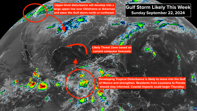
The ingredients for a storm to develop in the northwestern Caribbean Sea or the southern Gulf of Mexico are coming together more or less as expected. On the current schedule, a storm will develop midweek and track toward the northern Gulf or the west coast of Florida. Impacts could begin as early as Thursday.
How strong the storm will be and exactly where the most intense effects will occur is an open question. There is a general consensus in the various computer forecasts on how the steering pattern will evolve, but it's the details that make a difference in whether a storm hits one location or another location hundreds of miles away.

A satellite image on Sunday, Sept. 22, 2024.
(NOAA)
A robust upper disturbance just moving ashore in western Canada is forecast to develop into a large, quasi-stationary upper-level low-pressure system over Oklahoma, Arkansas and surrounding states. Meanwhile, a high-pressure system will establish itself east of Florida. This pattern should be in place mid- to late-week. The flow between those two features will be, broadly speaking, from south to north, providing a path for a storm in the southern Gulf.
The exact location of the low and the high, and the orientation of the steering flow between them varies in the various computer forecasts. Slight angles make a lot of difference in this kind of situation. No one should focus on any one forecast at this point since we don't even know exactly where the storm will develop, so we don't know the starting point of its track.
The National Hurricane Center is still drawing a large potential development zone because the disturbance hasn't even begun to get organized. Their development odds are in the high category, however, and almost every computer forecast shows a storm beginning to form in a couple days.
If trends continue, Hurricane Watches could be issued for some part of the Gulf Coast Tuesday or Wednesday.
Residents on or near the coast between Louisiana and Florida should stay well informed. This will be a fast-developing situation, so now is the time to think through what you would do in the potentially affected areas if a significant storm comes your way late in the week.

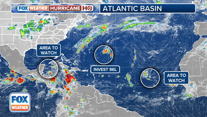
This image shows an overview of the tropical Atlantic Ocean.
(FOX Weather)
Out in the tropical Atlantic, a disturbance forecast to move off Africa in the next couple of days has a decent chance of developing into at least a tropical depression as it tracks in the general direction of the Caribbean. There's no indication of a threat to land at this point, but we'll watch it to be sure.
Farther north in the Atlantic, a disturbance southeast of Bermuda is unlikely to develop.