Bryan Norcross: Increasing threat of powerful hurricane impacting Florida Thursday
There's an increasing threat of an powerful hurricane impacting Florida on Thursday with strong effects spreading inland.

Bryan Norcross: PTC Nine designated in the Caribbean
The consensus landfall point is near Panama City or Tallahassee in the Florida Panhandle, although some outliers are closer to Tampa Bay and over the western Panhandle.
Updated at 11 a.m. ET on Monday, Sept. 23, 2024
Rarely do the various computer model forecasts show the level of agreement that they do today for a developing system. A weather pattern is forecast to be in place this week that would seem to support a powerful hurricane moving north from the Caribbean into the northern Gulf of Mexico. The consensus landfall point is near Panama City or Tallahassee in the Florida Panhandle, although some outliers are closer to Tampa Bay and over the western Panhandle.
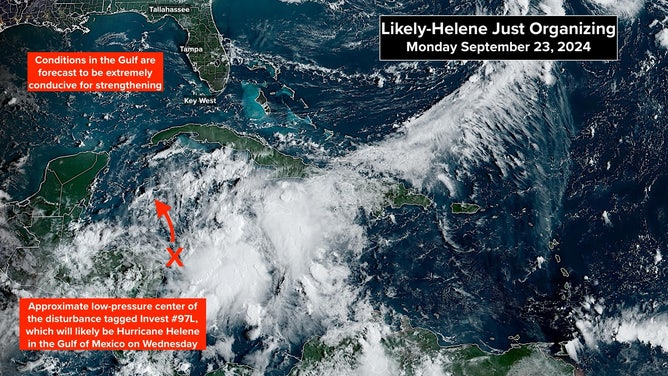
The future storm that will likely become Hurricane Helene is brewing in the western Caribbean.
(NOAA)
The storm hasn't yet developed, so expect adjustments to the forecast track.
Impact day in the Panhandle or the Big Bend would be Thursday on the current schedule, though water rise and edge effects would reach the Florida Keys and the southern peninsula beginning Wednesday. We are in King Tide season, which will add to the storm surge height.
Likely-Helene should be moving at a steady clip, so impacts will extend well inland into Georgia and could reach Atlanta.
Tampa Bay and the surrounding region are on the edge of most current forecasts, although storm surge and dangerous weather are likely there. The forecasts have shifted a slight bit in that direction, so stay informed of the latest updates.
Unless something dramatically changes, full hurricane preparations will be required in the threat zone this week. The hurricane could reach Category 4 or stronger.
Here's the situation:
The developing tropical disturbance in the western Caribbean Sea got the temporary name Potential Tropical Cyclone Nine this morning. That designation allows watches or warnings to be issued for parts of Mexico, Cuba and nearby islands.
The system is likely to become Tropical Storm Helene by the time it reaches the southern Gulf of Mexico. Atmospheric conditions appear conducive for the system to strengthen into an intense hurricane over the Gulf. The seawater is exceptionally warm everywhere, but there is also an extra warm eddy the storm looks likely to encounter.
History tells us that tropical systems that pass over those deep, exceptionally warm pools of water can spin up quickly from the surge of extra energy. With likely-Helene forecast to pass over the eddy, we have to be ready for the possibility of an intense hurricane approaching the Florida coast on Thursday.
Based on what we know now, the likely impact zone is the Florida Panhandle around the Big Bend to perhaps the Tampa Bay area. Depending on the strength of the storm and the diameter of the strong winds, storm surge on the entire Florida west coast could range from minor to dangerous. As we've seen, the west coast and the Panhandle are extremely vulnerable to high storm surge.
Hurricane and Storm Surge Watches will likely be issued for the Florida coast tomorrow. The Hurricane Watch will indicate the possibility of sustained winds of at least 75 mph, while the Storm Surge Watch will mean the possibility of the Gulf water rising to dangerous levels. Because the Florida west coast is so susceptible to storm surge, the storm surge threat zone will be significantly bigger than the area put on alert for high winds.
Preliminary intensity forecasts range from Category 2 to Category 4. But intensity and track forecasts for a just-developing disturbance are always subject to significant adjustments. The bottom line is that we have to be ready for a strong hurricane to make landfall as early as Thursday.
Don't focus on the exact landfall location of any model forecast at this point. Until the system develops, the predictions can and often do jump around.
If I were in the potentially threatened areas, I would do a few things now.
* Fill Ziploc bags three-quarters full with water and stuff them in the freezer to minimize the air around whatever you have frozen. If the power goes out later in the week, this will keep the food in both the freezer and the refrigerator colder longer. Obviously, you'll want to open the freezer or refrigerator as little as possible. DO NOT turn your fridge down to a lower setting. You can use this for drinking water if it eventually melts.
* Think about important papers and other items in the house that you want to be sure are safe. Plan to put them into heavy-duty trash bags. Your dishwasher and dryer are good places to put the bags.
* Get some duct tape and plastic painter's sheets – the kind you put on the floor when you're painting the walls. If the storm is coming your way, put a plastic sheet in the bathtub and fill it three-quarters full of water. That water will be used to flush toilets and for cleaning up if your water supply goes out.
* If you haven't done it already, pick up your hurricane food and water immediately. Even inland, you could get stranded at home while streets are being cleared. And if you end up evacuating, you'll need your supplies.
* You don't need gallons and gallons of store-bought water. Pots and pans and pitchers at home filled with tapwater will work just fine.
* Have a plan for where you'll park your car where a tree can't fall on it and a flood can't get it. A parking garage is a great option if there is nowhere close by.
Most importantly, stay well informed. This situation will develop quickly. The storm will likely get named by tomorrow and make landfall Thursday.
The steering scenario is pretty certain, but the details count. A big upper-level low-pressure system is forecast to form more or less over Arkansas, and a high-pressure system is off the Southeast coast. The corridor between those two systems is open to the north, putting the storm track over the Florida Panhandle or the northern Florida Peninsula.
This could turn into an extreme situation, so it's time to think carefully about your vulnerabilities and options if you might be in the threat zone.
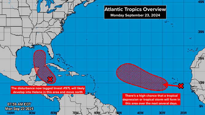
The tropical weather outlook for the Atlantic Basin.
(National Hurricane Center)
Out in the Atlantic, a system that just moved off Africa has a high chance of developing into at least a tropical depression or tropical storm in the middle of the Atlantic. There's no indication that it would threaten land at the current time.