Bryan Norcross: Impacts from Hurricane Helene to begin late Wednesday in Florida; last day to prepare
By this afternoon, Helene will be in the southern Gulf of Mexico on a path for the northern Florida Gulf Coast. The National Hurricane Center’s forecast and the computer forecasts agree that Hurricane Helene will make landfall Thursday evening on the coast south or southeast of Tallahassee.

FOX Weather is your Hurricane HQ.
(FOX Weather)
Updated at 9:30 a.m. ET on Sept. 25, 2024
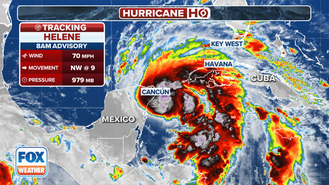
Tropical Storm Helene is on the cusp of reaching hurricane strength. The storm’s structure is now very well-formed. By Wednesday afternoon, it will be in the southern Gulf of Mexico on a path for the northern Florida Gulf Coast. The National Hurricane Center’s forecast and the computer forecasts agree that Hurricane Helene will make landfall Thursday evening on the coast south or southeast of Tallahassee.
Remember, if the center of the storm leans to the right side of the cone and makes landfall too far southeast of Tallahassee, the millions of people in the metropolitan Tampa Bay area will face much worse conditions. It’s a close call.
Helene's large circulation will spread dangerous conditions of one sort or another across all the state except perhaps the far western Panhandle. Damaging winds that will knock out power over a wide area are forecast. Storm surge is predicted to reach life-threatening levels along much of the Gulf Coast including in harbors, bays, inlets and rivers that open to the Gulf.
Helene will pass over a pool of high-energy water Wednesday night and Thursday on its path to the north. Significant intensification is expected at that time. The National Hurricane Center is forecasting a Category 3, which means we have to be ready for a Category 4. Some computer forecasts are very aggressive with the strengthening.
The latest information on Tropical Storm Helene.
(FOX Weather)
A strong hurricane that is extremely expansive is a terrible combination. Helene is forecast to be bigger than 90% of the Cat 3+ hurricanes in the record book. The long reach of the strong winds will move more Gulf water toward the coast than smaller storms, meaning the storm surge will reach higher depths than you might expect from previous experience.
The storm surge number is the height that the Gulf or bay water at that location could reach above normal high tide. In other words, if you went to the coast and stood on the high-tide line, an "up to 8-feet" storm surge forecast would mean that the seawater COULD be that high at that point. You can imagine how far inland that much water would go over a barrier island or into low-lying neighborhoods.
Because storm surge is so dangerous – it's unsurvivable if it overwhelms you – the National Hurricane Center's storm surge forecasts alert you to the possibility of the water height in your area. For example, if you are in a segment of the coastline where the storm surge forecast is 5 to 8 feet, that means that SOMEWHERE in that zone, the maximum water height above normal high tide is forecast to reach 8 feet. It's not a forecast for the entire delineated area, but it's as precise as modern science allows. The idea is to be sure that no one is surprised, and everyone who could face inundation can get out in time.
There is high confidence that storm surge in the Big Bend of Florida southeast of Tallahassee and down the Nature Coast to near Tampa will be unsurvivable. It's critical that people in those coastal communities follow local instructions and stay informed.
Due to the large radius of strong winds on the east side of the center of Helene's circulation, dangerous storm surge will occur well outside the cone along the entire west coast of Florida. Everyone near any waterway along or near the Gulf of Mexico should understand the threat for their local area. It's easy to be surprised how far inland storm surge can go. Local governments will issue evacuation orders for areas that might be flooded or cut off due to the water flooding in. If you live in any of the affected communities, be sure you know what the local instructions are.
Increasing winds will spread from south to north up the Florida Peninsula beginning later Wednesday. As the storm strengthens Wednesday night and Thursday, it will also track closer to the west coast of the state, meaning bands of heavy rain with high wind gusts will rotate inland. Deteriorating weather Thursday means preparations should be finished Wednesday.
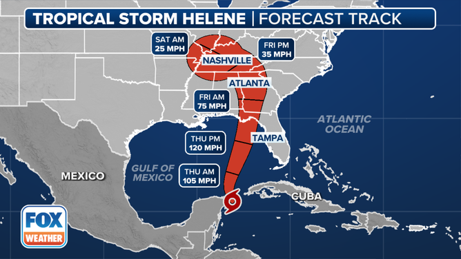
This graphic shows the forecast track for Tropical Storm Helene.
(FOX Weather)
The most intense impacts from Hurricane Helene will occur between Apalachicola and the Tampa Bay area. If the center of the storm tracks down the middle of the National Hurricane Center cone, the worst winds will miss metropolitan Tampa/St. Petersburg, though storm surge is still a threat. But a shift to the right side of the cone will bring even higher storm surge and stronger winds to the Tampa Bay region. That's why the Hurricane and Storm Surge Warnings are in effect there.
A Hurricane Warning means that residents should prepare for a hurricane. Based on everything we know and what modern science can discern, the National Hurricane Center believes that the risk of hurricane-force winds is high enough in those areas to issue the warning.
Wind gusts strong enough to knock out power will affect much of the peninsula, including along the east coast. Tropical Storm Warnings are in effect for the entire Florida east coast and extreme southeastern Georgia. Bring in furniture and anything else that might blow around in the yard and on high-rise balconies. Be ready for the power to go out. Winds could gust 50 or 60 mph, especially around high-rise buildings.
In Southwest Florida, residents should expect tropical-storm-force winds gusting to near hurricane-force and be aware of the storm surge threat along the coast, in the harbors and up the rivers. Don't compare this storm to Hurricane Ian. It's a different animal. It will be farther offshore and weaker, but it will be larger in diameter, so the storm surge will affect a wider area, even if the water is not as high.
The Tampa Bay region, including Sarasota and the surrounding barrier islands, are extremely vulnerable to storm surge. The good news is, this hurricane will move by quickly, so the onshore push of surge won't last for multiple tide cycles. Thursday will be the day. The National Hurricane Center is predicting 5 to 8 feet of water rise above the normal high tide in and around Tampa Bay. The 8 feet would occur somewhere in that region if the peak surge comes in at high tide, and the storm tracks near the right side of the cone. But even a 5-foot surge would be life-threatening.
Again, it's critical that everyone in that very complex region pays attention to their local emergency management instructions.
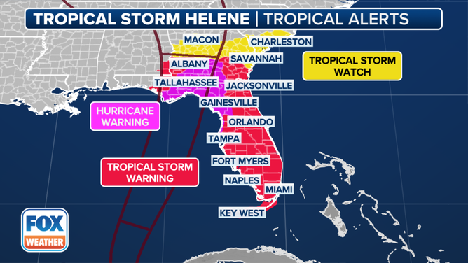
Current tropical alerts in effect for Tropical Storm Helene.
(FOX Weather)
Tallahassee is obviously near the center of the cone. Hopefully the center of Hurricane Helene will track to the east of the city, which will somewhat lower the impacts because the winds will come off the land instead of directly off the Gulf. But there's no guarantee. In any case, it's very likely that there will be widespread power outages, trees will be down on top of homes and cars, and it will take some time to recover. Everyone in the Tallahassee region should be ready for an extended period without power.
The Florida Panhandle west of Panama City should be OK, although gusty winds are likely. The Panama City area is on the fringe. If the storm were to track down the left side of the cone, there would be significant impacts. That seems less likely, however, than a shift to the east, if there is any significant shift at all.
Inland areas of the Florida Peninsula from metro Orlando north could experience strong enough winds to knock down trees and take out power. Be careful about where your car is parked and be ready for an extended period without electricity.
In terms of the steering currents, the question is, what will be the position of the upper-level low centered over Arkansas or western Tennessee, plus or minus? These so-called cut-off lows are always tricky to forecast because they don't have any well-defined steering currents to push them one way or the other. Their movement is somewhat random.
If the low shifts a little east, Helene is more likely to track down the right side of the cone and be a bigger threat to a large number of people along the west coast of Florida. The point is, we need to be ready for that possibility, and that's why the National Hurricane Center has the Hurricane Warnings and Tropical Storm Warnings in place for a large portion of the coast.
If you're in the threat zone, what you do Wednesday could have a dramatic impact on how comfortable you are after the storm has passed. Now is the time to take action.
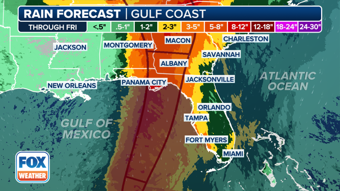
The rainfall forecast for the Southeast because of Tropical Storm Helene.
(FOX Weather)
Dangerous weather will spread north into Georgia, possibly including metro Atlanta. It will be a close call there. Flooding rain could affect much of Georgia over the next couple of days and spread into South Carolina, North Carolina, Tennessee and points north. This large hurricane will carry a tremendous amount of moisture far inland along with its gusty winds, which will cause flooding and knock out power over a large area.
Everybody in the affected areas of Florida and the Southeast should be on high alert.
Here are the tips I've published over the last couple of days, though I took out the suggestion to freeze Ziploc bags full of water because there's not enough time now. It takes a few days for them to freeze. Wednesday is the day for action. Don’t wait.
- Follow evacuation orders if they are issued for your area.
- Charge up EVERYTHING electrical Wednesday. The power could go out Wednesday night.
- If you are in the potential high-impact zone or are evacuating, call a friend or relative out of town and designate them as the contact hub. Give your local friends and family that number. If local services are out after the storm, you all have someone to check in with when you are able.
- DO NOT turn your fridge down to a lower setting.
- Think about important papers and other items in the house that you want to be sure are safe. Plan to put them into heavy-duty trash bags if you think your house could be compromised. Your dishwasher, washer and maybe the dryer are good places to put the bags. Be sure your dryer can’t flood through its vent.
- Get some duct tape and plastic painter's sheets – the kind you put on the floor when you're painting the walls. If the storm is coming your way, put a plastic sheet in the bathtub and fill it three-quarters full of water. That water will be used to flush toilets and for cleaning up if your water supply goes out.
- Use the same painter’s sheets to cover furniture and electronics if necessary. Use duct tape liberally.
- If you haven't done it already, pick up your hurricane food and water immediately. Even inland, you could get stranded at home while streets are being cleared. And if you end up evacuating, you'll need your supplies.
- You don't need gallons and gallons of store-bought water. Pots and pans and pitchers at home filled with tap water will work just fine. Don't worry if the store is out of water. Buy empty jugs. If you use a new bucket or some other container to hold tap water, wash it with soap and water so it's sanitary. I would fill it with warm water and some bleach, then wash it out to be sure.
- Have a plan for where you'll park your car where a tree can't fall on it and a flood can't get it. A parking garage is a great option if there is nowhere safe close by.
- Now is the time to plug in any rechargeable batteries for things like power tools (for post-storm cleanup and repair), lights and tech (power banks).
- If you're evacuating to a hotel, book with the hotel directly. Not through a third-party website or service.
- Gas up the car, get extra cash, and buy a supply of important prescription drugs Wednesday. Don't wait.
- Plan for animals and pets now.
Good luck everybody!