Bryan Norcross: Major impacts in Florida from Hurricane Helene ahead of catastrophic landfall tonight
The storm is in the top 5 of the largest modern Category 3 or stronger hurricanes on record in the vicinity of Florida. Large-diameter hurricanes produce higher storm surges. The entire Gulf Coast of Florida will be affected.

FOX Weather is your Hurricane HQ.
(FOX Weather)
Updated at 9 a.m. ET on Sept. 26, 2024
We are just in phase 1 of a historic hurricane event. Hurricane Helene is intensifying in the Gulf of Mexico as it heads toward landfall on the northeastern Florida coast tonight.
The storm is in the top 5 of the largest modern Category 3 or stronger hurricanes on record in the vicinity of Florida. Large-diameter hurricanes produce higher storm surges. The entire Gulf Coast of Florida will be affected.
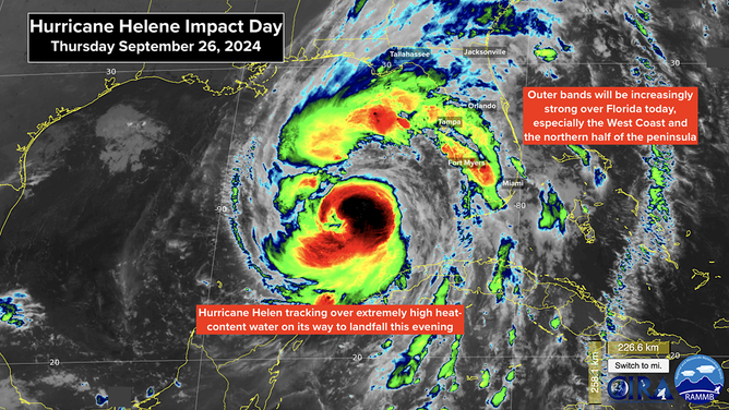
We are just in phase 1 of a historic hurricane event. Hurricane Helene is intensifying in the Gulf of Mexico as it heads toward landfall on the northeastern Florida coast tonight.
(NOAA)
Some coastal flooding is already underway. The Gulf water level along Florida's west coast will continue to increase during the day. Follow local instructions so you aren't trapped. The science that predicts storm-surge heights so people have time to get out is very exact. Don't take a chance.
Helene is starting out as a very large storm. The strong winds extend over 300 miles from the center, which more than covers the state of Florida. Tropical Storm Warnings for winds over 40 mph with gusts in many locations over 75 mph are in effect for all of the Florida Peninsula and north into the Carolinas, Georgia, eastern Tennessee, and part of Alabama.
Through the day today, Helene will pass over a super high-energy pool of water that is expected to help the system intensify rapidly. The National Hurricane Center is forecasting Helene to reach high-end Category 3 or Category 4 strength this afternoon as it heads for the coast south or southeast of Tallahassee.
If Helene comes ashore as a Category 3 or 4 as forecast, it will be the strongest hurricane to make landfall on that part of the Florida coast in more than 150 years. There was a devastating hurricane that impacted the Big Bend of Florida and Tallahassee in 1842. Nothing since then has come ashore as a Category 3 or higher in that area. Hurricane Idalia hit farther south last year, of course, and mostly missed Florida's capital city.
The Gulf water will be pushed up to 20 feet above normal high tide on the coast south of Tallahassee around to Cedar Key. A little farther south in the Tampa Bay metropolitan area, up to 8 feet of storm surge is possible if the peak of the push from Helene's winds occurs at high tide. It is critical that everyone near any waterway that opens to the Gulf from Panama City around the coast and south to Southwest Florida knows what the storm surge forecast is for their area and reacts according to emergency management instructions.

Helene now Category 2 hurricane as Florida braces for catastrophic landfall impacts
Hurricane Helene is forecast to blast Florida with widespread damaging winds, life-threatening storm surge and major flash flooding when it makes landfall on Thursday.
People died unnecessarily in Hurricane Ian because they weren't aware of the storm surge threat for where they lived. Let's not let that happen again. Seek out information and instructions from your local officials. They will have analyzed the threat and have a plan to keep everybody safe.
There's no way to know exactly where Helene's outer bands will set up, but over the entire Florida Peninsula, winds will be gusty enough today to knock out power. In addition, in the areas under repeated tropical downpours, local flooding is possible. Keep everything charged and be aware of where you park your car. Find high ground and don't park under a tree.
Phase 2 of the storm will be this evening when Helene makes landfall. Based on everything we know, damage will be widespread around Tallahassee east and west and far north into Georgia. These are heavily treed communities that will not handle extreme winds. Power could be out for weeks.
In the Panhandle, action can still be taken this morning to be ready for what's coming tonight. Have a stockpile of food and water in case you get trapped at home. Know where you'll ride out the storm. An interior closet, hallway, or bathroom is usually the safest space. Get a mattress off the bed and have it ready for protection if the worst happens and your home starts coming apart. Stay away from windows.
Along the coast south and southwest of Tallahassee, the storm surge will be unsurvivable. No one should stay anywhere near any waterway that feeds into the Gulf, even well away from the coast.
In the Tampa Bay area, including St. Pete Beach and the barrier islands, the storm surge is forecast to reach up to 8 feet above normal in some part of that zone. It's imperative that everybody follow the instructions of emergency management immediately, so they are in place when the storm surge is likely to peak later today.
See the map with the storm-surge forecasts below.
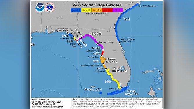
A look at the storm-surge forecast.
(NOAA)
Phase 3 of this catastrophic event will occur on Friday as the storm races into Georgia and stalls over the mid-South or the Midwest. A tremendous amount of tropical moisture will stream north. Life-threatening flash flooding is forecast for a large area from northeast Georgia across the upstate of South Carolina, western North Carolina and surrounding states. This is an extremely dangerous situation.
In metropolitan Atlanta, the winds could be strong enough to knock out power to millions of people. The exact track of the center of the storm on Friday is somewhat uncertain, of course. But if it tracks just west of Atlanta, as is currently forecast, hurricane-strength wind gusts could impact most of North Georgia. Now is the time to prepare for an extended period without power. Charge your devices. Store water in case the city's system fails.
If this storm tracks as forecast, it will have a bigger impact on metropolitan Atlanta than Hurricane Opal in 1995, which was devastating.
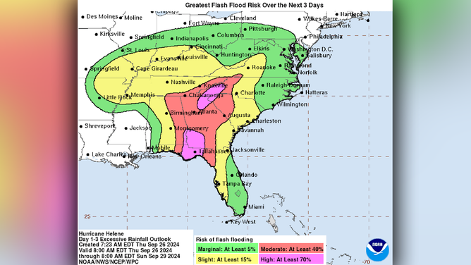
Phase 3 of this catastrophic event will occur on Friday as the storm races into Georgia and stalls over the mid-South or the Midwest.
(NOAA)
The potential impacts from Helene are so widespread that it's impossible to cover them in one post. Be sure you know what the National Weather Service is forecasting for your particular area. Life-threatening hazards are likely across the Florida Peninsula through large parts of the Southeast and into the mid-South and Midwest.
The weather pattern that's driving Helene north is very unusual. A large upper-level low-pressure system is centered over western Tennessee and Arkansas with a strong counterclockwise flow around it. A high-pressure system is over the Atlantic off the Southeast Coast. In between, there is a well-defined corridor to the north, which is where Helene will track.
Once Helene tracks through Georgia, it will be captured and eventually absorbed by the upper low. The combination of the energy and the moisture coming north with Helene and the energy in the upper low will create extreme weather conditions across a large area. The result is expected to be life-threatening floods, extreme winds, and tornadoes, especially east of the track of Helene's center. The threat extends across the Southeast all the way to the coast.
Today is impact day in Florida. Tomorrow is impact day farther north. Everybody in the affected areas should stay aware and stay informed. This is a highly unusual and, in some areas, an unprecedented event. Be ready and stay safe.