Bryan Norcross: Misery from Helene continues as we get ready to watch for development in the Caribbean again
But now that atmospheric conditions have returned more or less to normal, the tropics are alight.

FOX Weather is your Hurricane HQ.
(FOX Weather)
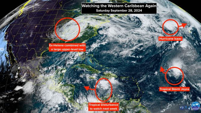
The area we'll have to watch extends from the western Caribbean into the southern Gulf. A similar weather pattern to the one that spit out Helene is forecast to develop over Central America. It's a broad area of low pressure – a Central American Gyre (CAG). A weak tropical disturbance moving across the Caribbean will meet up with the CAG and could develop into a tropical depression or tropical storm.
The National Hurricane Center has the odds of development over the next week in the medium range for now. Nothing looks likely to start organizing until midweek, and the computer forecasts show a variety of outcomes. There is, however, a loose consensus among the models that some sort of low-pressure system will be in the Gulf of Mexico late next week.
Even though the weather pattern is similar in broad strokes to the one that produced Helene, the details are different. The CAG is nowhere near as strong in the computer forecasts this time as it was before Helene formed. And the upper air pattern is quite different.

Watching the western Caribbean again.
(CIRA / RAAMB / FOX Weather)
Still, the atmospheric pattern looks reasonably conducive for a tropical system to try to form and then track from the western Caribbean toward the Gulf of Mexico late in the week.
The same caveats we discussed last week are still important. All forecasts for undeveloped or just developing systems are subject to change and large errors. Don't focus on any specific forecasts at this point.
HELENE AFTERMATH: The scope of the damage from Hurricane and later Tropical Storm Helene is stunning, even if the storm was well forecast. And the misery will continue for a good while. It will take time for the water from the torrential rains over the mountains and the higher elevations across the Southeast to drain to the Atlantic or the Gulf. In the meantime, rivers and streams and creeks will rage, and people will die if they don't follow local instructions.
The scope of the damage around the Florida Big Bend is just coming into view. And residents all along the Florida West Coast will be dealing with the aftermath of Helene for weeks, months, or longer.
Modern computer simulations – the so-called models – that predict both rainfall and storm surge flooding are incredibly accurate, if the track and intensity forecasts for the storm are reasonably good. That's how the National Hurricane Center was able to predict how much the tide would rise on Florida's West Coast, and how the National Weather Service was able to warn people in the Carolinas, Georgia, and Tennessee that historic flooding was coming.
Helene as a tropical system is no more. It was absorbed by the extensive upper-level low-pressure system helping steer it north. That combo system will linger over the Midwest before finally ejecting toward the Northeast after the weekend.

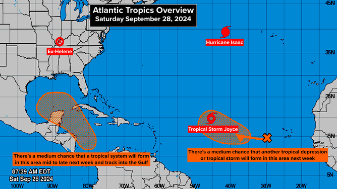
Atlantic Tropics Overview
(FOX Weather / FOX Weather)
THIS HURRICANE SEASON is not going to produce the number of named storms that was forecast, but the macro factors that led to those large numbers are indeed in place. The cause of the gap in storm production is still largely unexplained. We know what was abnormal in the atmosphere, but it's not obvious why the temperatures aloft were so warm, and the African weather pattern was out of whack. Much more research and analysis will be required.
But now that atmospheric conditions have returned more or less to normal, the tropics are alight.
HURRICANE ISAAC is tracking toward the North Atlantic. It won't be a threat to land. Tropical Storm Joyce is drifting north in the open Atlantic. It doesn't look like a problem either. And a third system has a good chance of developing next week in the tropical Atlantic. But even if it does, there is no sign it will be a threat.
The next two names are Kirk and Leslie.