Bryan Norcross: Concern that we'll have another tropical system in the Gulf this week
On the very approximate current schedule, the system will form in the western Caribbean around midweek and could impact somewhere on the Gulf Coast around the weekend. hatever happens with this system, it is not in any way related to Helene.

Forecasters monitoring new area for possible tropical development in Atlantic as hurricane season shows no signs of slowing
The National Hurricane Center has highlighted a new area for possible tropical development off the coast of Africa as hurricane season shows no sign of slowing down.
In an eerie repeat, the consensus of the computer forecast models is that another tropical system will develop in the western Caribbean and head into the Gulf of Mexico. There is no consensus, however, on how strong it will get, where it will track, and who might be affected. Although, the odds of a storm affecting Texas are much lower than farther east.
On the very approximate current schedule, the system will form in the western Caribbean around midweek and could impact somewhere on the Gulf Coast around the weekend.
Many possibilities are on the table. While the weather pattern is similar to the one that generated Helene in broad strokes, several differences could lead to a much weaker storm. However, there's no guarantee of that, and no way to know at this point.
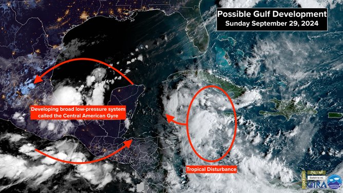
A look at the possible development in the Gulf of Mexico.
(CIRA / FOX Weather)
A broad area of low pressure is developing over Central America, spanning from the western Caribbean to the southern Gulf to the Pacific. This is the so-called Central American Gyre (CAG) that we talked so much about leading up to Helene's development. This time, however, the developing gyre does not appear to be as strong.
A tropical disturbance is tracking west through the Caribbean Sea. It will reach the western Caribbean in a few days, where the computer forecasts indicate it will team up with the CAG to create an independent area of low pressure. The rotation around the gyre will lift that new system north toward the Gulf. At least, that's the general scenario presented by the computer forecasts.
The atmospheric pattern is forecast to be conducive for development, at least for a while. A relatively small dip in the jet stream is forecast to move across the South late week, and that should shunt the system, if it develops, toward the northeast or east. Dry air and increasingly hostile upper winds might impact the potential system late week, which would limit the system's ability to organize and strengthen.
Obviously, the farther out in time we try to project what will happen, we can only talk about possibilities. So don't focus on any one forecast at this point.
This general development mechanism is what we expect in late September and October, so it's not super unusual. With so many people trying to recover from Helene, however, it is daunting to imagine another storm of any kind in the Gulf.
Whatever happens with this system, it is not in any way related to Helene. We have to watch for developments this week concerning this potential storm independently of what we've just been through.
There is nothing to do right now except to stay informed. Things should become clearer about Tuesday as the Caribbean disturbance approaches the circulation of the Central American Gyre.
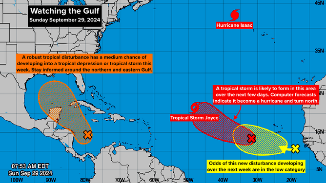
An overview of what Bryan Norcross is tracking in the Atlantic Basin.
(FOX Weather)
ELSEWHERE IN THE ATLANTIC, Hurricane Isaac and Tropical Storm Joyce are tracking into the open ocean and will not be a threat to land. Both systems are forecast to weaken soon.
And there are two more disturbances in the eastern Atlantic with development potential. The easternmost system is likely to develop into a tropical storm and eventually a hurricane. The computer forecasts all show it turning north into the open Atlantic.
The system that just moved off Africa currently has low chances of developing. In any case, it also looks likely to turn north.
The next three names on the list are Kirk, Leslie, and Milton. Milton replaced Michael, which was retired after 2018. The lists recycle every 6 years.