Bryan Norcross: Slow-developing Caribbean tropical disturbance might still be a threat in the Gulf
The National Hurricane Center is monitoring three disturbances for development into at least a tropical depression this week.

Trio of tropical threats monitored in the Caribbean and Atlantic
FOX Weather Hurricane Specialist Bryan Norcross gives an update on the three tropical disturbances monitored in the Atlantic and Caribbean and delves into when will the hurricane season return to life?
Updated at 11:30 a.m. ET on Tuesday, Sept. 3, 2024
There are three disturbances on the board. None show signs of significant development yet. Still, Tropical Disturbance #1, the system plodding across the Caribbean Sea, has the potential of developing as it approaches Mexico and again in the Gulf.
The National Hurricane Center has Disturbance #1's development chances in the medium range. But remember, the odds pertain to the system becoming a tropical depression – a fairly low bar that just requires the system to develop an organized circulation.
The latest consensus from the various computer forecast models is that development might occur in the western Caribbean or the Gulf, somewhere near the Yucatán Peninsula of Mexico. The predictions have been all over the place from a well-organized storm or hurricane to no development to speak of.
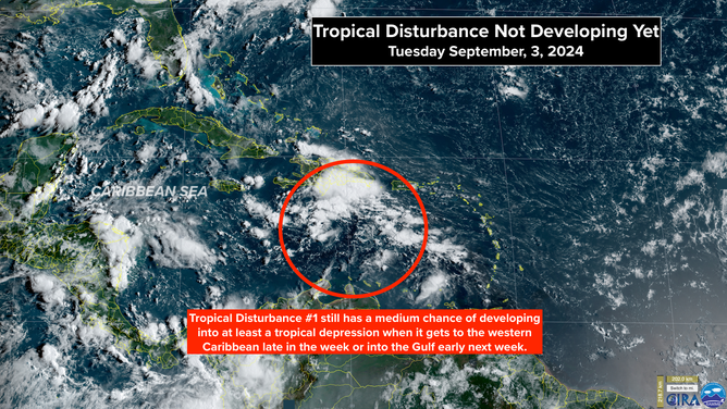
Satellite image of Tropical Disturbance No. 1.
(CIRA)
On the current schedule, the disturbance will arrive in the western Caribbean about Friday. At the same time, a broad low-pressure area developing over Central America will try to deflect the system into the southern Gulf near the Mexican coast, or it could pull the disturbance over Central America. A cold front and a dip in the jet stream will be across the northern Gulf, so if the system ends up over the Gulf water and stalls over the weekend or early next week, it could still end up being pulled north.
There are reasonable scenarios that extend well into next week before the system makes its final move. I always say, forecasts for undeveloped systems are likely to change, and this one is no exception. So we have to keep an open mind about the possibilities after the weekend.
The front forecast to drape across North Florida and the northern Gulf is likely to produce an extended period of heavy rain over a good part of the Gulf Coast and the so-called Sunshine State. Here is the National Weather Service's rainfall forecast for the next seven days.
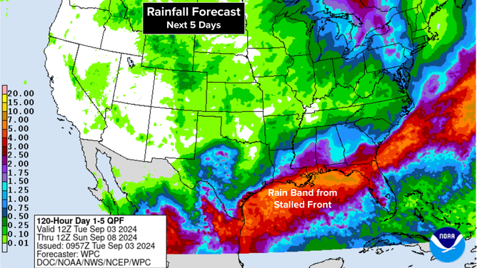
Rain will impact the track of Tropical Disturbance No. 1.
(NOAA)
In the eastern Atlantic, Tropical Disturbance #2 is tracking west just under a plume of Saharan dust. The National Hurricane Center is giving this system a medium chance of developing into at least a tropical depression. The current expectation is that it will veer to the north and not be a threat to land.
Tropical Disturbance #3 is a reincarnation of the system that came off Africa last week. It has a slight chance of developing into a depression before atmospheric conditions become hostile.
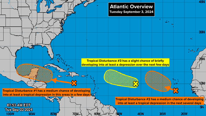
Three tropical disturbances in the Atlantic Basin
(NHC)
There's more evidence of odd and very unusual weather over Africa. Long-range computer forecast models are predicting significant rainfall over the Sahara Desert. Much of that desert never sees rain most years.
The weirdness is related to the far-north track that disturbances are taking across the continent this hurricane season. The cause and effect are unclear, but there is little doubt that the nonstandard weather pattern over Africa is related to the limited storm activity in the eastern Atlantic.
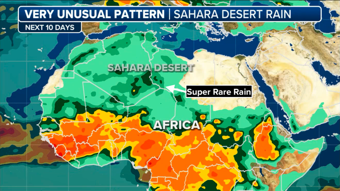
Unusual weather pattern over Africa suppressing tropical development in the Atlantic
(FOX Weather)
In addition, the pulse that travels around the Earth (called the MJO) that alternately enhances and suppresses tropical activity has been in the suppression mode over the Atlantic. The overall unsupportive conditions are expected to last for at least another couple of weeks, and the magnitude of the suppression is forecast to increase.
That doesn't mean nothing can form, but on average, systems don't get as strong when the MJO is suppressing them.
The timing would seem to indicate that the MJO will be in an enhancing state about the same time that the La Niña in the Pacific kicks into a mode that also supports storm development. It's clear that the forecasts of big numbers of named storms this season are not going to work out. But based on what we know, late September and October could still produce plenty of strong hurricanes.