Bryan Norcross: Tropical development in the Gulf is still possible next week
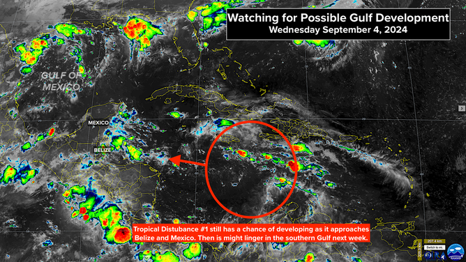
The one of the most interest is Tropical Disturbance #1 in the central Caribbean. No development is expected right away, but it might end up in the extreme southern Gulf of Mexico where it could eventually organize.

FOX Weather is your Hurricane HQ.
(FOX Weather)
Updated at 12 p.m. ET on Wednesday, Sept. 4, 2024
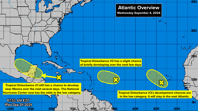
There are three disturbances with some potential to develop across the Caribbean and the Atlantic, but none are organizing quickly. And there's a good chance they'll never do so.
The one of the most interest is Tropical Disturbance #1 in the central Caribbean. No development is expected right away, but it might end up in the extreme southern Gulf of Mexico where it could eventually organize.
The National Hurricane Center has lowered the system's development odds slightly. They are now in the low range. The computer forecast models show a wide range of possibilities for the future track and disposition of the system. One reasonable scenario is for the disturbance to end up stalled in the Gulf.
Satellite image of tropical disturbances over the Atlantic.
(NOAA)
On the current schedule, the disturbance will be approaching Mexico's Yucatán Peninsula on Friday. It might develop a circulation before making landfall, but its window of time will be short. It's forecast to be over land on Saturday. At that point, lots of possibilities open up.
A broad area of low pressure is forecast to develop over Central America. That system might absorb the disturbance, direct it into the mountainous terrain, or fling it toward the southern Gulf of Mexico. Either of the first two possibilities would, obviously, kill off the system. It's the third scenario that we have to watch out for.
If some version of the disturbance ends up in the southern Gulf on Sunday or Monday, it might sit around for a while. The steering currents are forecast to be very light. When systems stall over the extremely warm Gulf waters, we pay close attention.
In addition, the old cold front that's been contributing to the heavy Texas rain could somehow combine with the disturbance later in the week. As with all forecasts for undeveloped systems, the details are subject to significant changes. For now, we'll just keep an eye out for the possibility of the disturbance crossing the Yucatán and ending up in the Gulf next week.
Between the Caribbean and Africa, Tropical Disturbances #2 and #3 now have low chances of developing into tropical depressions. Neither is expected to threaten land, even if they do develop.
Three tropical disturbances in the Atlantic.
(NHC)
An analysis of the current lull in the tropics has been released by Dr. Phil Klotzbach and the team at Colorado State University. For the next two weeks, tropical activity is forecast to continue below normal. It's not 100% clear what's causing this extended slow period at the heart of the hurricane season, but the expectation is that the factors suppressing tropical development will revert to a more supportive mode later in the month or no longer be an issue.
Most of the meteorological contributors to this unusually long period with no storm development are related to the suppression or disruption of disturbances moving off Africa into the east Atlantic. Later in the season, we watch disturbances in the Caribbean and Gulf, so the Africa factors become less important.
The Atlantic Ocean water remains extremely warm, and the upper-level winds will likely become more conducive to storm development as the La Niña pattern strengthens in the Pacific.
The bottom line is that we still expect strong hurricanes to form this season, despite the current lull.