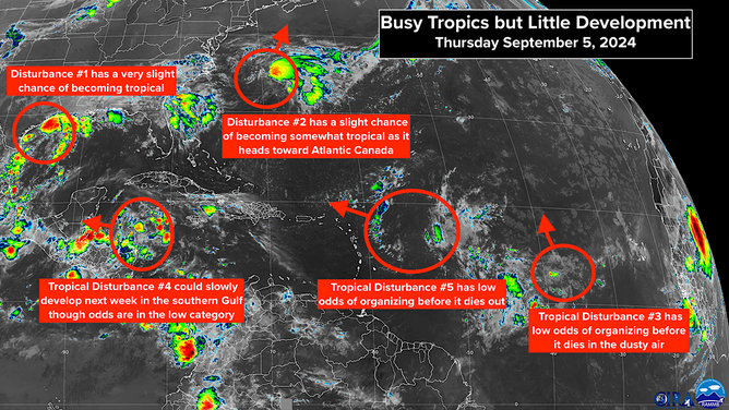
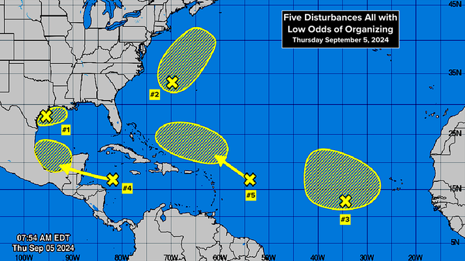
Bryan Norcross: 5 disturbances to watch but development odds low on all of them
The one we've been interested in for the last week, Tropical Disturbance #4, is on track to reach Belize and Mexico tomorrow. Development is unlikely before it moves over land.

FOX Weather is your Hurricane HQ.
(FOX Weather)
Updated at 9:30 a.m. ET on Thursday, Sept. 5, 2024
Disturbances with some chance of developing are scattered across the map. The one we've been interested in for the last week, Tropical Disturbance #4, is on track to reach Belize and Mexico tomorrow. Development is unlikely before it moves over land.
Our concern has been that it might emerge into the southern Gulf and then turn into a problem. That's looking less likely, but it's still not completely off the table. The odds are that the system will die over Central America or perhaps cross into the Pacific and turn into a storm there.
Disturbances with some chance of developing are scattered across the map.
(NOAA)
On the off chance that it does end up in the southern Gulf of Mexico, it's likely to move very little for a while. The steering currents are forecast to be weak. In the end, it could combine with a front to the north or Disturbance #1, which is causing the heavy rain in Texas and Louisiana. Nothing is going to happen fast, and most likely, nothing is going to happen at all with this disturbance alone. We'll see how the various fronts and disturbances interact next week.
Disturbance #2 is connected to a cold front offshore of the East Coast. As it moves northeast, there is some chance it could become an independent system and take on some tropical characteristics. The National Hurricane Center has those chances in the low category. Atlantic Canada will feel the effects of this system, whether it becomes somewhat tropical or not.
Tropical Disturbance #5 also has a low chance of developing. Its window is short before it runs into hostile conditions. As it passes north of Puerto Rico and the Virgin Islands about Sunday, rain chances there will increase.
Tropical Disturbance #3 is going to run into hostile conditions as it turns towards the north into dry and dusty air.
The overall atmospheric pattern across the Atlantic is not conducive to storm development at the moment.
(NOAA)
The overall atmospheric pattern across the Atlantic is not conducive to storm development at the moment. That doesn't mean it couldn't happen, but as a rule, systems have a harder time developing in this kind of environment.
Long-range forecasts indicate that the cap will lift after the middle of September. The other factors that are conducive to storm development will still be in place, of course. We'll see what happens, but we can't write off this hurricane season because this stretch has been uncommonly slow.