Bryan Norcross: Lots of areas to watch, but none is ripe for tropical development
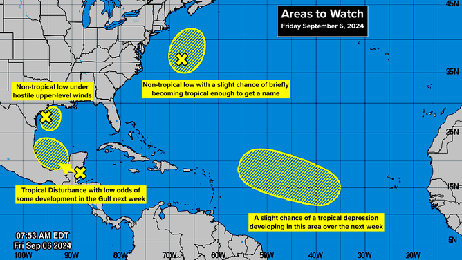
There are four areas still highlighted by the National Hurricane Center to watch for tropical development, but all four remain with low odds of it occurring.

FOX Weather is your Hurricane HQ.
(FOX Weather)
Updated Friday Sept. 6 at 11 a.m. ET
Even though the potential development areas are all yellow, which means the National Hurricane Center's odds are in the low category, some of the systems are still producing significant weather.
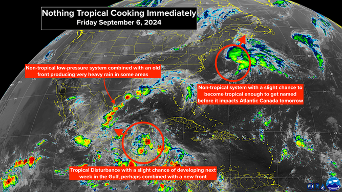
Satellite imagery shows no short-term tropical development
(NOAA)
In the Gulf of Mexico, a nearly stationary non-tropical low-pressure system offshore of southern Texas combined with a cold front draped along the northern Gulf coast has combined to produce periods of torrential rain over the coastal sections of Texas, Louisiana, and into Mississippi. Hostile upper-level winds have kept this system from evolving into a tropical system, even over the very warm water of the Gulf.
Standby along the Gulf coast... better weather is coming... temporarily.
A cold front pressing in from the north should push most of the rain offshore, although some coastal sections still have rain in the forecast through the weekend. Strong winds are predicted near the coast and offshore as the front and the low-pressure system interact.
Next week, some part of the disturbance moving across the Yucatàn Peninsula - Belize and Mexico - will be in the Gulf. There is a slight chance that it and the new front might combine into a tropical system, but more likely, the moisture from the disturbance will interact with the front to cause another round of rain along the coast from Texas to Florida.
At this point, the odds of tropical development next week from this new combo system appear low, but not zero.
Off the East Coast, another non-tropical low-pressure system is attached to a cold front. The system has a little window of time to take on some tropical characteristics. It would get named Francine if it did because winds with the system are already over 40 mph.
Most likely this system will plow north into Atlantic Canada and remain non-tropical. In any case, winds will start to increase in Nova Scotia tonight. Rain and wind will last through tomorrow, but nothing they can't handle.
In the Central Atlantic, the big yellow blob there is due to yet another meandering weak tropical disturbance. Development chances are low, and there is no apparent threat.
Four areas to watch for potential tropical development
(NOAA)
The lack of typical trade winds, which blow east to west across the Atlantic, is among the unusual aspects of the weather pattern over the last month or so. It's no doubt related to the odd location of the storm track over Africa.
This is the reliable flow of air that brought Christopher Columbus to the New World and powered European trading ships for centuries. When it's operating normally, the east-to-west energy helps spin up tropical systems in the east Atlantic this time of year. Lately, however, we've seen systems lollygagging around, waiting for the wind to blow.
That's all good, of course, but a bit disconcerting since we don't yet understand the full cause and effect of what's going on to make the pattern so different this year. If you're not being drenched by days of rain, enjoy the calm.