Bryan Norcross: Focusing on the Gulf next week for possible tropical development
Our main area of interest now is in the Gulf of Mexico where a combination of systems has a good chance of coming together and developing into a tropical depression or tropical storm.

FOX Weather is your Hurricane HQ.
(FOX Weather)
Updated Saturday 9:30 a.m. ET
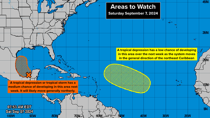
Our main area of interest is in the Gulf of Mexico. A combination of systems has a good chance of coming together and developing into a tropical depression or tropical storm. The National Hurricane Center has increased the odds of development into the medium range beginning tomorrow and becoming more likely midweek.
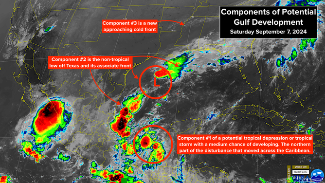
The tropical disturbance we tracked across the Caribbean this week is one of the ingredients. The northern flank of that system is moving into the extreme southern Gulf of Mexico. The non-tropical low-pressure system and its associated front, which together have been dousing Texas and Louisiana with heavy rain, are the second components. An approaching cold front that will move into the Gulf today is the third.

Winds are already forecast to be over 40 mph in the northern Gulf associated with the non-tropical low and the fronts, so there’s a good chance the system would jump right to Tropical Storm Francine if it develops.
The strong consensus of the computer forecasts is that the unified system would move north over or near the Mexican coast and then track north toward Texas or Louisiana. The atmospheric environment looks reasonably conducive for a tropical system to strengthen, so the big questions are: does the system consolidate, and how close to the coast does it track?
Regardless of how strong potential-Francine gets, the tropical system combined with the front across the northern Gulf is likely to bring another round of very heavy rain to the coastal sections of Texas and Louisiana. This will fall on top of already saturated ground, so flooding will once again be possible.

(NOAA)
Everybody near the coast in Louisiana and Texas should stay well informed this week as we see how the three systems come together.
IN THE ATLANTIC BETWEEN THE CARIBBEAN AND AFRICA: A slow-moving, weak disturbance has a slight chance of developing into a tropical depression over the next week. The system is currently forecast to be in the general vicinity of the northeastern Caribbean islands in about a week. Stay tuned.