Bryan Norcross: Texas and Louisiana on alert as Francine looks likely to form in the western Gulf
East Texas and Louisiana should be on alert for the possibility of a tropical storm or hurricane late Tuesday or Wednesday.

FOX Weather is your Hurricane HQ.
(FOX Weather)
Updated at 10:30 a.m. ET on Sunday, Sept. 8. 2024
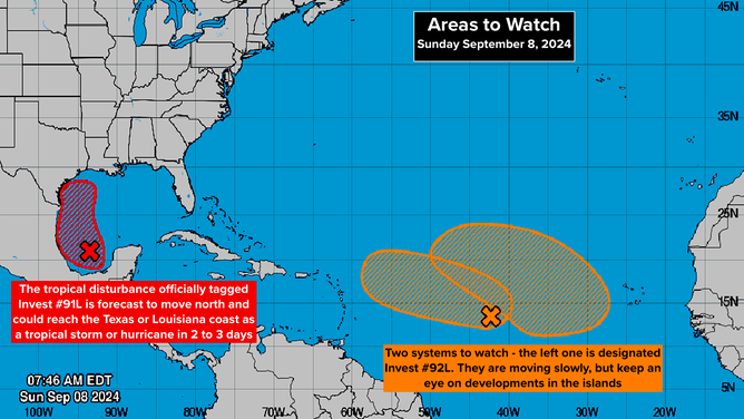
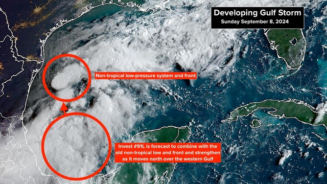
A well-organized disturbance in the extreme southern Gulf of Mexico – officially tagged by the National Hurricane Center as Invest 91L – will likely combine with last week's big Gulf rain-making low-pressure system. The combo system could be named Tropical Storm Francine by tomorrow.
The steering flow rotating around a high-pressure system centered over Florida will drive likely-Francine to the north just offshore of the Mexican and Texas coasts. People in East Texas and Louisiana should be on alert for the possibility of a tropical storm or hurricane late Tuesday or Wednesday.
The atmospheric pattern over the western Gulf looks conducive for likely-Francine to develop until the system reaches the northwestern Gulf. As always, the Gulf water is very warm. The track close to the Mexican and Texas coastline and the system's relatively short time over the Gulf should limit development. Also, as likely-Francine approaches East Texas or Louisiana, dry air and increasingly hostile upper winds might come into play.

(NHC)
Tropical Storm or Hurricane Watches will likely be issued today for parts of the Texas and Louisiana coasts. The various computer forecasts show many possibilities for the strength of the storm when it reaches the coast, between a fairly low-end tropical storm and a Category 1 hurricane. Stay informed on the latest forecasts. Once the system actually develops, we should have a better idea of what to expect.
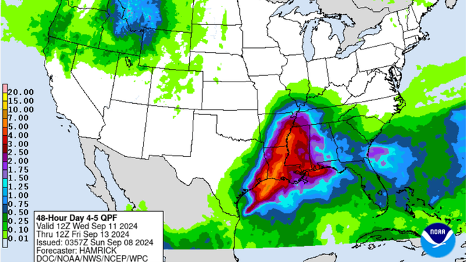
No matter how strong likely-Francine gets, very heavy rain looks likely. Here is the current forecast from the National Weather Service.

(NOAA)
Rain falling at multiple inches per hour is possible. The ground in southern Louisiana is already saturated, so there is a serious potential for flooding as the storm moves north and dies out in the mid-South.
Midway between the Caribbean and Africa, there are two tropical systems trying to get organized. The odds of development for both of them are in the medium range. The one closest to the Caribbean has been officially tagged Invest 92L by the National Hurricane Center.

(NOAA)
Whether these systems maintain independence or merge with a third disturbance moving off Africa is an open question. Nothing is happening quickly in the eastern Atlantic. The steering currents have collapsed.
Residents of the Caribbean islands should stay informed, but currently, these systems don't appear to be a threat to land.
The Atlantic seems to be waking up from its tropical slumber. It's unclear, however, whether this is the start of the expected busy hurricane season or just a blip of activity.