Bryan Norcross: Hurricane forecast to impact Louisiana or Texas midweek
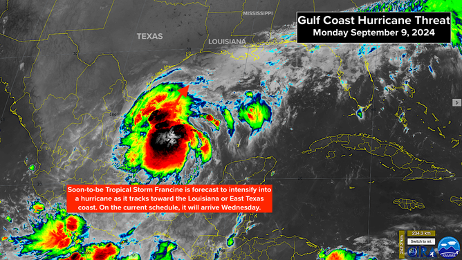
The developing storm in the southern Gulf of Mexico is currently expected to intensify into a hurricane. This will likely be named Francine as it moves toward the East Texas or Louisiana coast.

FOX Weather is your Hurricane HQ.
(FOX Weather)
Updated at 10:30 a.m. ET on Monday, Sept. 9, 2024
The developing storm in the southern Gulf of Mexico is slowly moving to the north. Since it's forecast to organize into at least a tropical storm, the National Hurricane Center has designated it Potential Tropical Cyclone Six. A potential tropical cyclone is simply a disturbance that is expected to develop into an organized storm before it gets to land. Watches and/or Warnings are issued for potential tropical cyclones.

Potential Tropical Cyclone 6 forecast to become a hurricane later this week
(NOAA)
The tropical disturbance we followed across the Caribbean last week is merging with the low-pressure system responsible for the heavy rain in Texas. The combo system will track north just offshore of the Mexican coast as it develops an organized circulation. Hurricane Hunters have already found winds of 50 mph, so when it organizes the system’s name will jump right to Tropical Storm Francine.
The water is plenty warm in the western Gulf, and the upper-level environment looks conducive for strengthening. The current thinking is that likely-Francine will intensify as it moves toward the East Texas or Louisiana coast. The National Hurricane Center is forecasting the system to be at hurricane strength at landfall, but there are two important points to be made.

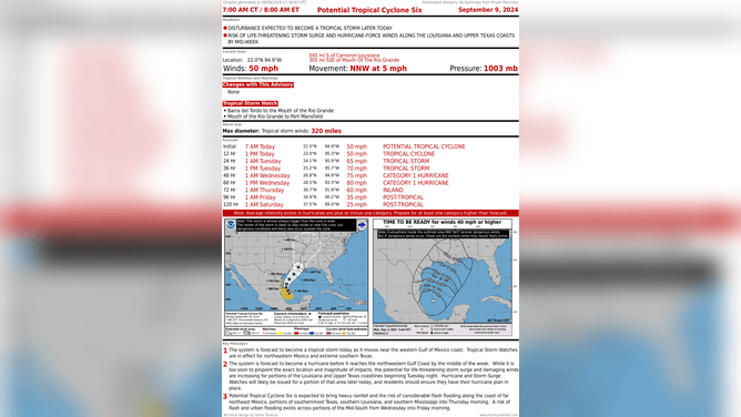
Risk of life-threatening storm surge and hurricane-force winds along the Louisiana and Texas coasts
(NOAA)
First, forecasts for undeveloped systems are always iffy and subject to larger-than-normal errors. The computer forecast models, in general, are not designed for ill-defined systems. And second, residents should always plan for a storm at least one category higher than forecast. In this case, that means preparing for at least a Category 2.
The biggest apparent deterrent to strengthening is that the storm will make landfall on Wednesday on the current schedule. So time for intensification will be limited. Some computer forecast models indicate that there could be a period of rapid intensification, but upper-level winds might become somewhat hostile near landfall time. The net-net is, at this point, planning should be for at least a Cat 2.
Look for warnings – including Storm Surge Warnings – to be issued for the northwestern Gulf Coast today. The coastline there is very vulnerable to high and damaging storm surge, so it's critical that coastal residents pay close attention to local information and instructions.
Heavy tropical rains will spread north from the coast into southern Mississippi. The ground is saturated from the long-duration rain event last week. Be alert for flood warnings that are likely to be required mid- to late-week.
Information will change quickly on likely-Francine, so expect frequent updates from public officials and emergency managers, as well as new advisories on the storm.

Two disturbances churn in the Central Tropical Atlantic
(NOAA)
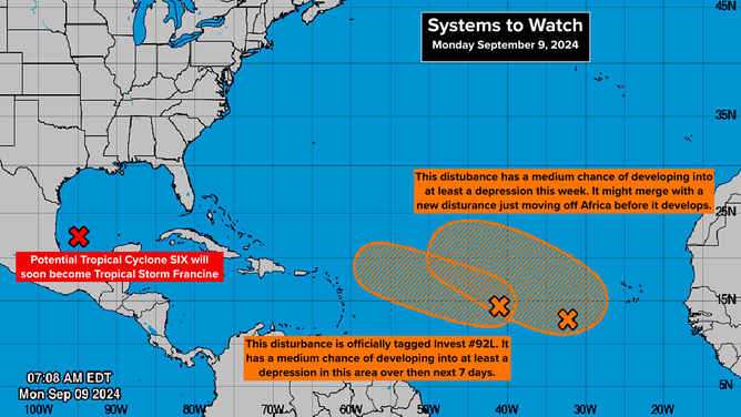
In the central tropical Atlantic, two slow-moving systems are in the development stages. The one on the left is officially designated Invest 92L. The National Hurricane Center has both disturbance's odds of developing into at least a tropical depression in the medium range.
There is no good consensus among the computer forecast models on the future of the lefthand system. It could track near or just north of the northeastern Caribbean islands, however, so residents there should stay informed. As with all just-developing systems, forecasts are more likely to change.
The system on the right has a bit of a complicated story. Yet another disturbance moving off Africa might catch up to it so they can merge in some fashion. In any case, nothing is going to happen quickly. Some kind of complicated interaction of all three disturbances is also possible.
Tomorrow is the day, on average, when we are most likely to have a named storm somewhere in the Atlantic Ocean, the Caribbean Sea or the Gulf of Mexico. The name after Francine on the list is Gordon. Odds are that we'll be using that name soon.