Bryan Norcross: New tropical disturbance to watch on the far side of the Atlantic
The attention turns to a tropical disturbance that moved off Africa on Monday. The National Hurricane Center only gives development a slight to fair chance of happening over the next week.

FOX Weather is your Hurricane HQ, streaming free 24/7.
(FOX Weather)
Updated at 8:30 a.m. EDT Wednesday:
Another day, another disturbance. Neither of the two areas of disturbed weather we were watching – one in the Caribbean and one east of the Bahamas – could find a conducive patch of atmosphere. They are both now off the table.
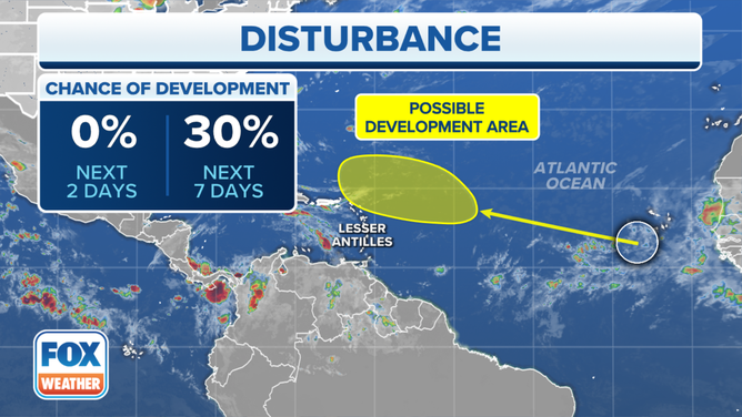
Our attention turns to a tropical disturbance that moved off Africa on Monday. It’s proceeding west into the prime hurricane belt but has a mass of dry air ahead of it. Based on current forecasts, the first chance the system would have to develop comes over the weekend when the disturbance is about 3/4 of the way to the vicinity of the northeastern Caribbean islands.
The National Hurricane Center only gives development a slight to fair chance of happening over the next week.

The National Hurricane Center is tracking a tropical disturbance in the Atlantic off the coast of Africa that has a 30% chance of development over the next seven days.
(FOX Weather)
A dip in the jet stream moving off the East Coast of the U.S. is expected to be strong enough to pull the system farther north than the previous disturbances we’ve tracked this year. You see a gradual bend in the track toward the north. In the long term, whether the jet stream dip will be strong and persistent enough to turn the system – whatever shape it’s in – out to sea is an open question.
So far, the computer forecast models have not been helpful with this system. Some show it developing, and others show little more than a moisture surge moving along with the typical tropical flow. This is not surprising because computer forecasts are notoriously unreliable before a defined system develops.
On the current schedule, the disturbance would be in the general vicinity of the northeastern Caribbean around the first part of next week, if it gets that far.
It’s still early in the year to be looking to the tropical Atlantic for development. That season usually begins in August when the Saharan dust lets up, and the wind flow across the Atlantic is less robust. With so much of the atmospheric pattern out of whack (in an extreme kind of way) around the world, it’s good to see the tropics behaving in a normal way, at least for now.
No other development is indicated in the next week.