Bryan Norcross: Slight chance of development in the Atlantic and a buzz in California about the tropics
The system most likely to develop is still over Africa but has some chance of organizing once it moves off the coast late today or early tomorrow and tracks into Potential Development Area #2. The second system is an ill-defined disturbance buried in the strung-out area of showers and thunderstorms that’s a semi-permanent feature in the tropical Atlantic this time of year.

FOX Weather is your Hurricane HQ, streaming free 24/7.
(FOX Weather / FOX Weather)
Updated Tuesday at 8:40 A.M.
The National Hurricane Center is painting two areas in the tropical Atlantic where there is some chance a tropical depression might develop over the next several days.
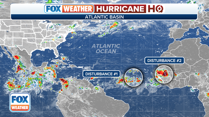
The National Hurricane Center is monitoring two areas in the Atlantic for possible development.
(FOX Weather)
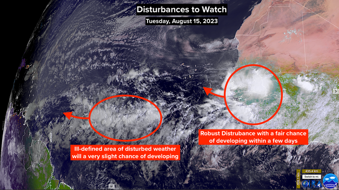
The system most likely to develop is still over Africa but has some chance of organizing once it moves off the coast late today or early tomorrow and tracks into Potential Development Area #2. The system is reasonably well-defined as these things go, so the NHC is giving it slightly higher odds of developing into at least a tropical depression than its brother to the west. Overall, the chances are still in the low category, and it’s window to develop is only a few days.
Early forecasts indicate the system will turn toward the north, but forecasts for systems that haven’t developed yet are always low confidence. We’ll know if it’s behaving as expected in a couple of days.
The second system is an ill-defined disturbance buried in the strung-out area of showers and thunderstorms that’s a semi-permanent feature in the tropical Atlantic this time of year. Computer forecast models indicate that a discrete disturbance might eventually emerge and initially track in the general direction of the Caribbean islands.
There is no indication that the system will be a significant threat to land, but we’ll watch to be sure.
NOAA satellite view monitoring two areas in the Atlantic for possible development.
(NOAA)
Southern California is buzzing with speculation about a tropical system early next week. Indeed, some computer forecasts show a tropical-moisture surge from Sunday to Tuesday. The system in question has not yet organized, but the National Hurricane Center says development is likely off the southern coast of Mexico in the next few days.
The disturbance is currently offshore of Central America. The consensus of the computer forecast models is that it will become Tropical Storm and possibly Hurricane Hilary as it moves north, paralleling the Mexican coast. There’s a fair chance that some version of the system could affect the Southland of California, even if it’s just fringe moisture.

Pacific Tropics Overview on Tuesday, August 15th.
(FOX Weather)
Even a surge in tropical moisture can have a significant impact on Southern California. The mix of tropical air and the mountains that crisscross the region can produce significant and dangerous flash flooding. It’s too early to know what will happen, but everyone in SoCal should stay aware of the forecasts for the beginning of next week.
The Southern California climate record shows one hurricane, which hit San Diego in 1858, and a tropical storm that came ashore around Long Beach in 1939. The 1939 storm caused widespread destructive flooding across the Southland. And Southern California had a fraction of the population that it has today. So we know it can happen, though it’s always unlikely.
It’s important to remember that forecasts for undeveloped or just-developing systems are highly unreliable. We need to see if and how Tropical Storm Hilary develops to know if there is really any threat of an effect on SoCal.
Otherwise, there is no immediate threat to the U.S. or surrounding areas.