Tropical disturbance to watch heading toward the Caribbean
If either of these tropical systems acquires winds of at least 40 mph, it would be named Julia.

The podcast Tracking the Tropics with Bryan Norcross is now available to stream.
(FOX Weather)
Updated at 9:30 a.m. EDT
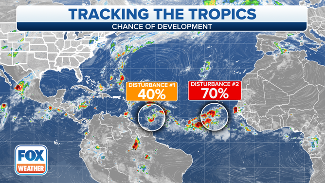
Tropical Disturbance #1 shows signs of organization about 700 miles east of the southern Caribbean islands. The atmospheric environment appears reasonably conducive for the system to develop into a tropical depression or tropical storm over the next few days as it strolls toward the islands.
The steering currents are weak, so the moisture surge related to the system, whatever form it’s in, isn’t expected to reach the islands until Thursday or Friday.
HOW TO WATCH FOX WEATHER ON TV
The main computer forecast models do not support the disturbance turning into much. They show dry air ahead on the track, and somewhat hostile upper-level winds impacting the system when it reaches the Caribbean. In any case, people in the southern Caribbean islands should be ready for at least a healthy moisture surge with gusty winds, if not a developed system.

An overview of the tropics in the Atlantic Basin.
(FOX Weather)
The current forecast pattern over the Caribbean does not appear conducive for further development. But in any case, a blocking area of high pressure will develop to the north of the disturbance and keep it moving west.
Tropical Disturbance #1 doesn’t look to be any threat to the U.S. or nearby areas at this time.
Tropical Disturbance #2 on the far side of the Atlantic is likely to develop into at least a tropical depression. Its track will take it north into the open ocean. However, it is not expected to threaten land.
If either of these systems acquires winds of at least 40 mph, it would be named Julia.
Otherwise, nothing appears to be on the horizon as the atmosphere kicks into autumn mode.
FOX Weather Hurricane Specialist Bryan Norcross has a podcast, Tracking the Tropics with Bryan Norcross, available now on FOX News Audio. You can get it on your device by clicking here.