Bryan Norcross: Tropical storm conditions to impact the Texas coast Wednesday
The consensus of the computer forecast models is that the giant circulation will likely consolidate before it makes landfall on the Mexican coast Wednesday night or early Thursday. Naming the system won't make any difference to the impacts on the Gulf Coast. It's purely for the record book.
Watching for tropical development off Southeast coast and in Gulf of Mexico
While Potential Tropical Cyclone One brings tropical storm conditions to Texas, forecasters are watching for tropical development in two other areas of the Atlantic Basin over the next several days.
UPDATED 9 a.m. ET Wednesday
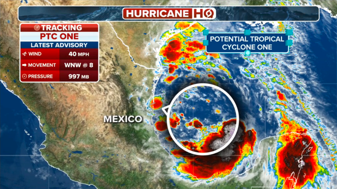
The Gulf system officially designated Potential Tropical Cyclone ONE (the technical name for a potential tropical threat) has not yet organized around a well-defined center, so it can't be officially named Tropical Storm Alberto yet.
The consensus of the computer forecast models is that the giant circulation will likely consolidate before it makes landfall on the Mexican coast tonight or early tomorrow. The National Hurricane Center is giving that an 80% chance of happening, but it might run out of time. In any case, naming the system won't make any difference to the impacts on the Gulf Coast. It's purely for the record book.
The strong winds to the north of the ostensible center of potential Alberto are caused by the air being squeezed between the tropical system's low pressure and the extra strong heat-dome high-pressure system over the northeast US. Those persistent gusty winds blowing east to west are already pushing the water toward the coast, causing minor to moderate storm-surge flooding at high tide.

The latest information for Potential Tropical Cyclone One as of June 19, 2024.
Tides have been 2 to 4 feet above normal on the northern Gulf Coast, especially in Louisiana and Mississippi. But today, the focus will be on the Texas coast, where the strongest onshore winds will occur. High tide tomorrow morning will likely see additional flooding.
Winds of 40 to 50 mph are likely on the southern half of the Texas coast, with gusty winds affecting the rest of Texas and across the northern Gulf.
There is a widespread risk of flash flooding from the southern counties of metro Houston to the Mexico border. Five to 10 inches of rain is forecast with up to 15 inches possible in some areas. South Texas is in a drought, so the land can absorb quite a bit of rain. If it doesn't all come at once, it will be a good thing – they are desperate for water. On the other hand, areas around Houston were drenched in May, which means it will flood with less rain.
The rain threat near the coast from potential Alberto should end Thursday morning. However, it will still be quite breezy throughout the day, keeping the tide levels somewhat higher than normal.
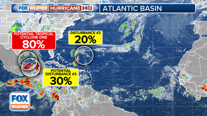
NEXT IN THE GULF: Then, weirdly, we look to the same spot in the southern Gulf for the next potential tropical system. The consensus of the computer forecasts is that another low-pressure area will develop late Friday or early Saturday and move slowly over the same waters tread by potential Alberto. For now, we are calling this system Potential Tropical Disturbance #3.
This system will keep the onshore winds blowing along the Texas coast, though so far, it's forecast to be weaker than potential Alberto.

The tropical weather outlook for the Atlantic Basin.
(FOX Weather)
A key rule applies here, however. Forecasts for systems that have not yet developed or are just developing are always subject to significant changes.
The National Hurricane Center has the chance of this system developing into at least a tropical depression in the low category for now. But the atmospheric pattern is forecast to be conducive to strengthening, so let's keep an open mind.
IN THE ATLANTIC: The system we've been watching in the Atlantic is related to an old front and an upper-level disturbance, Disturbance #2, does not look likely to develop. The various computer forecast models have mostly lost interest. Still, a weak area of low pressure is forecast to arrive at the Southeast coast as a briefly gusty moisture surge Thursday night or Friday. The National Hurricane Center still gives it a slight chance of developing tropical characteristics before that time.
As is typical in June, dry air and Saharan dust cover the tropical Atlantic and extend into the Caribbean, so no development is expected there.
