Bryan Norcross: Vince has a medium chance of forming in the Atlantic
Over the next few days, the low will track south over increasingly warmer water and might separate from the fronts and draw energy from the ocean. If that happens, the system will be said to have acquired tropical characteristics.

FOX Weather is your Hurricane HQ, streaming free 24/7.
(FOX Weather)
Updated at 9:30 a.m. EST on Thursday
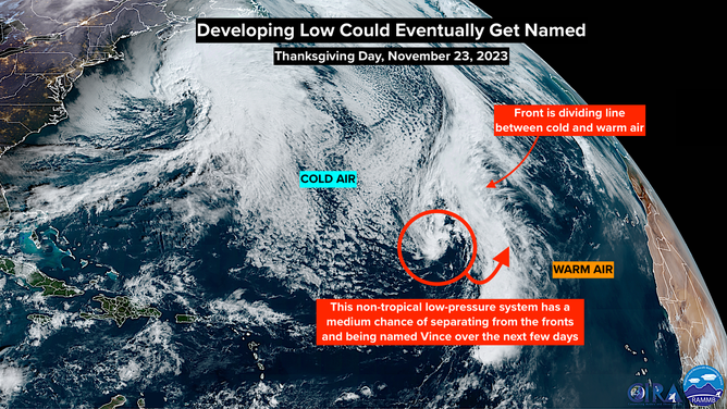
A low-pressure system is forming on schedule about 1,400 miles northeast of Puerto Rico. It's currently connected to a vast frontal system extending from the North Atlantic into the tropics. The front is the boundary separating cold air that moved off the North American continent from tropical air over the ocean. It's the contrast between those air masses that are currently powering the system.
Over the next few days, the low will track south over increasingly warmer water and might separate from the fronts and draw energy from the ocean. If that happens, the system will be said to have acquired tropical characteristics.

A satellite image over the tropical Atlantic Ocean on Thursday, November 23, 2023.
(NOAA)
Since the low already has winds over 40 mph, it would jump right to a subtropical storm – meaning it's a hybrid, drawing power from the air's temperature contrast and the warm seawater – or a fully tropical storm. If either happens, it will get the name Vince.
The National Hurricane Center is giving that process a medium chance of happening at some point over the next few days.
The system could threaten the Azores – offshore islands of Portugal – over the weekend.
Otherwise, the tropics have taken on a wintertime posture.
Happy Thanksgiving!