Bryan Norcross: Watching for tropical development this week near Florida and in the Gulf
There is a good chance for a tropical depression to form during the middle of the week in the Gulf of Mexico.

Forecasters keeping their eyes on potential tropical developments in Atlantic, Gulf of Mexico
The National Hurricane Center is tracking two potential tropical disturbances, one in the Atlantic Ocean and one in the Gulf of Mexico, that could impact weather here in the U.S.
Updated Sunday at 9:30 a.m. ET
Looking at the 30 years from 1991 to 2020, the average development date for the first named storm in the Atlantic, the Caribbean Sea or the Gulf of Mexico is in the third week of June. It looks like Mother Nature might be getting organized right on schedule.
A large low-pressure system over Central America is causing continuous heavy rain, enough to produce flash floods and mudslides in and around the mountains. In the next day or two, a moisture surge from the Caribbean will merge with the large low. The combination of the two systems is forecast to evolve into a tropical disturbance in the southwestern Gulf of Mexico.
The upper-level atmospheric pattern over the western Gulf is forecast to be reasonably conducive for tropical development. The National Hurricane Center is painting a potential development zone and giving the system a good chance of becoming at least a tropical depression around the middle of the week.
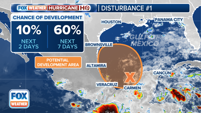
The latest on Potential Tropical Disturbance #1 in the Gulf of Mexico.
(FOX Weather)
A strong high-pressure system – a so-called "heat dome" – is developing over the northeastern part of the U.S. Extreme temperatures are forecast this week across the Midwest, mid-Atlantic, New England and Canada.
The high will block the tropical system in the Gulf, whatever form it takes, from moving too far north and deflecting it toward the coast of Mexico or possibly South Texas. Even if the system does not organize, an extended part of the Gulf coast of northern Mexico and Texas will feel brisk onshore winds laden with tropical moisture. The band of strong winds will be boosted by the contrast in air pressure between the tropical low and the extremely strong heat-dome high-pressure system to the north.
South Texas is officially in a drought. So rain will be welcome unless too much comes at once, like we saw in South Florida last week.
Plan to stay aware of developments in the western Gulf this week. If winds associated with the circulation of the tropical system reach 40 mph, the storm will be named Alberto.
The old front and atmospheric river that flooded South Florida are finally moving away into the Atlantic. But the system might not be finished fooling with us.
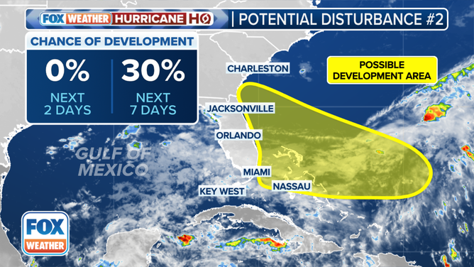
The outlook for a potential tropical disturbance in the southwestern Atlantic.
(FOX Weather)
There is some chance a low-pressure system will develop from the remnants of the front and its associated upper-air system and track toward Florida or the Southeast this week. There's nothing to look at now, but computer forecasts show that possibility. The upper-level winds are forecast to be marginal for any development, but we'll keep an eye on the waters east of the Bahamas.
The National Hurricane Center gives the system a low chance of developing into a tropical depression in the large yellow area. The potential development period begins midweek.
The heat-dome high will also prevent this system from heading out to sea. Whatever form it takes, it will be forced toward Florida or the Southeast coast. As with the Gulf system, there will be a large area of windy conditions well north of the system's center due to the pressure contrast with the heat-dome high. But let's see what develops.
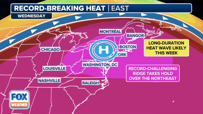
Record-breaking heat is expected across the Ohio Valley and Northeast this week.
(FOX Weather)
Farther north, the weak disturbance previously designated Invest 90L has merged with the front and is no longer a factor.
Saharan dust extends across the Atlantic and into the Caribbean, so no development is expected from there for the next seven days or longer.
This is the kind of tropical activity we expect in June. However, the extra warm water and the extreme strength of the northeast heat dome will enhance the impacts of developing systems.