California atmospheric river’s relentless rains turn burn scars into roaring torrents of mud
Previous atmospheric river events have flooded Northern California, but according to the FOX Forecast Center, this storm is set to be the strongest for Southern California so far this season.

Atmospheric river brings flooding areas devastated by wildfires in Southern California
An atmospheric river brought 2-8" of rain and multiple feet of snow to California since Wednesday evening. The rain prompted flooding across the state. Numerous roads were closed across northern California. Heavy snow prompted CalTrans to briefly hold traffic on Interstate 80 over Donner Pass due to multiple spinouts and heavy snow in the Sierra Nevada.
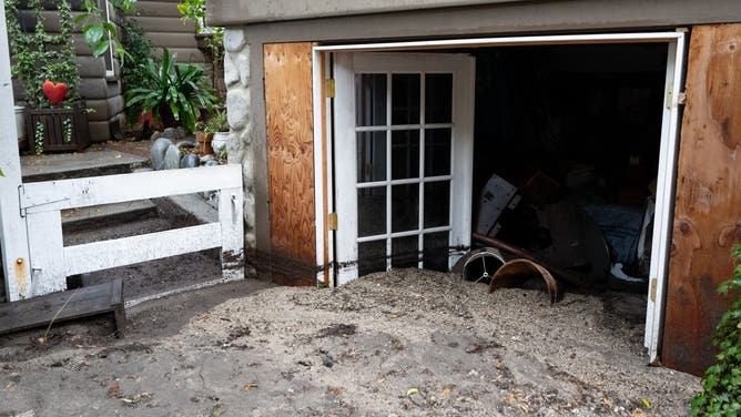
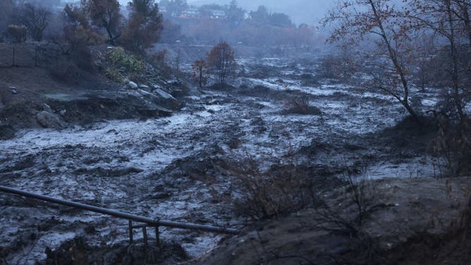
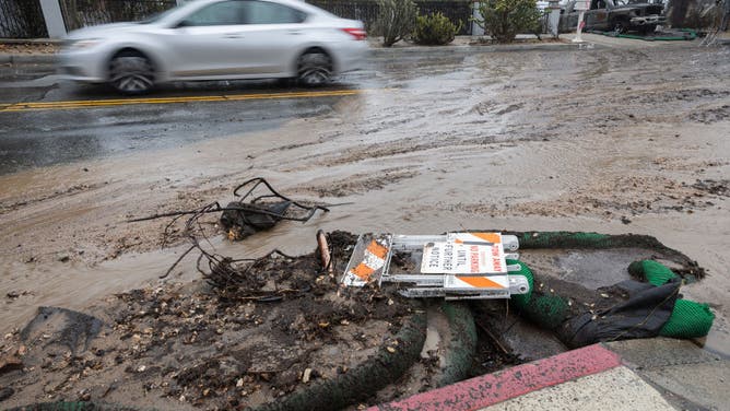
LOS ANGELES – Torrential rains from a potent atmospheric river soaked nearly the entire state of California Thursday, triggering flash flooding up and down the state and transforming burn scars left from historic wildfires in Southern California into streams of mud.
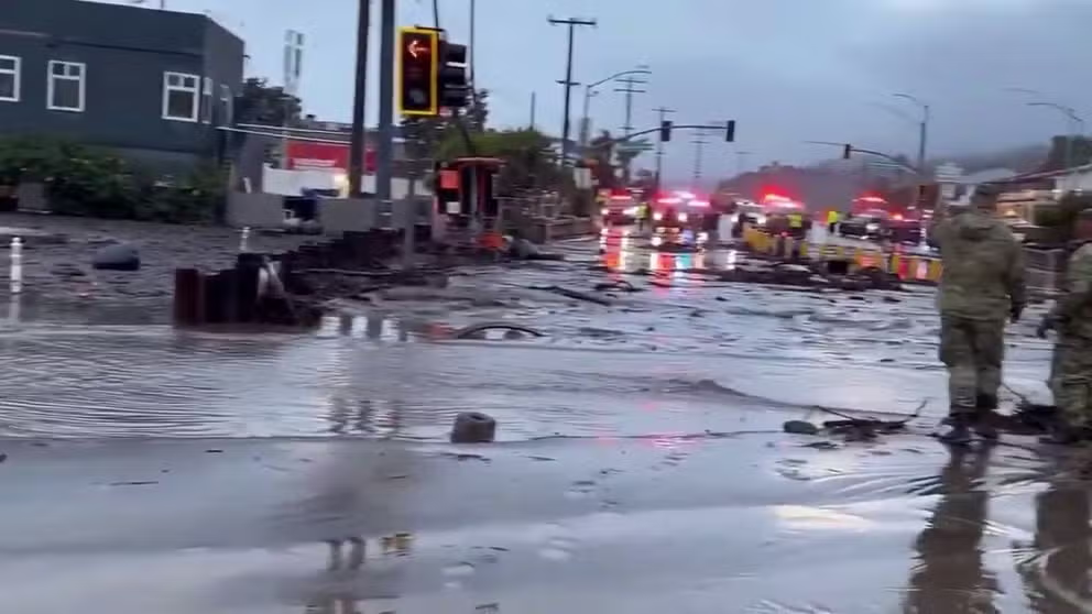
Las Flores road in Malibu, California hit with mudslide amid atmospheric river
Las Flores road in Malibu, California which was impacted by the Palisades Fire was innundated with debris after an atmospheric river caused mudslides on Thursday (Alexandra Datig via Storyful).
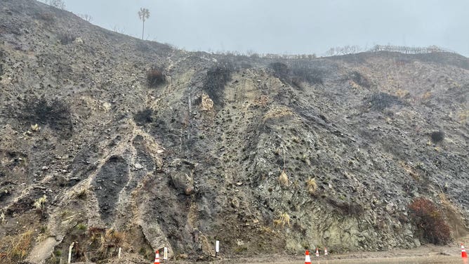
Video taken from around the burn scar left from the deadly Palisades fire showed roadways becoming mud streams as rainfall rates were estimated to have reached at least an inch per hour. Residents near burn scars in multiple counties had been told to either evacuate or be ready to at a moment's notice as the storm arrived.
"There is mud and debris everywhere," said Gigi Graciette with FOX 11 Los Angeles as she stood along the city's Sunset Boulevard. "You can see tree branches and excess of metals that we believe what was left of someone’s burned home. This is up and down Sunset Boulevard."
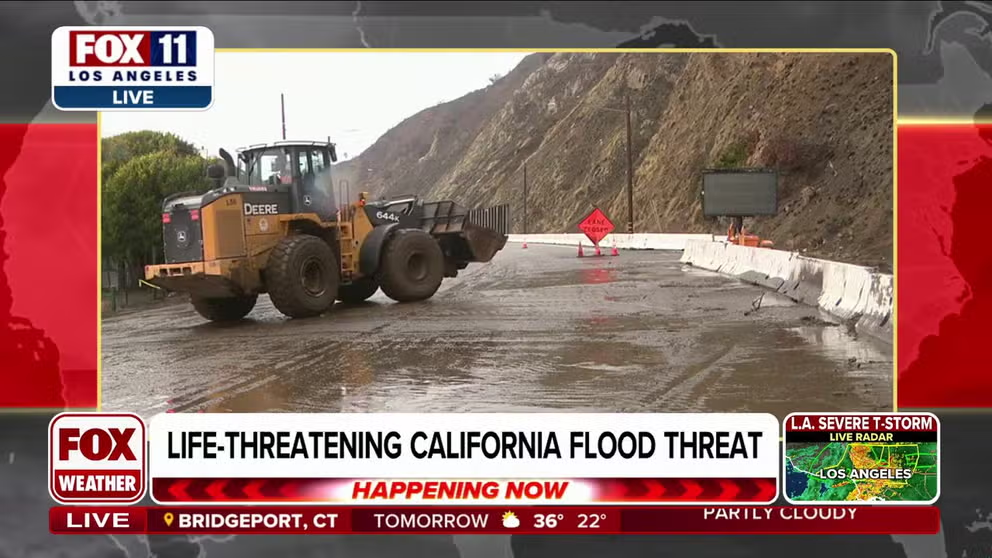
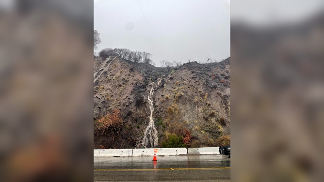
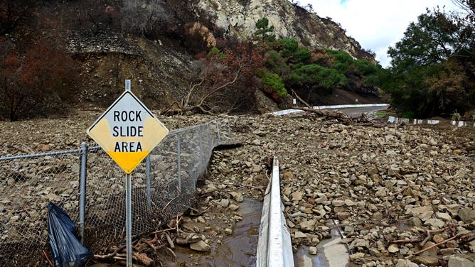
Rainfall, mud make roadways impassible around Palisades burn scar
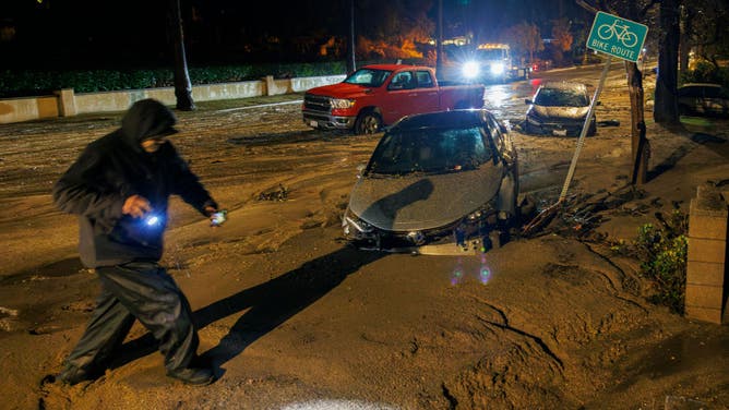
Heavy rainfall rates were too much for some areas around Los Angeles to handle as impassable roadways were encountered around the Palisades burn scar.
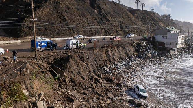
The California Department of Transportation (CALTRANS) closed a portion of the Pacific Coast Highway between Santa Monica and Malibu ahead of the storm, and mudslides and debris flow later poured across the highway. "Even workers (along PCH) had to scramble to get out of the way there was so much mud and so much debris," Graciette said.

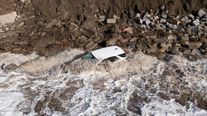
Los Angeles Fire Department vehicle swept off Pacific Coast Highway into ocean
A Los Angeles Fire Department vehicle with a man inside was swept off the PCH and into the ocean by a debris flow in Malibu on Thursday. "Fortunately, the member was able to exit his vehicle and reach safety with minor injuries," a LAFD public information officer said (Video Credit: @PIOErikScott).
A Los Angeles Fire Department vehicle with a man inside was swept off the PCH and into the ocean by a debris flow in Malibu.
"Fortunately, the member was able to exit his vehicle and reach safety with minor injuries," a LAFD public information officer said about the incident. "He was transported to a local hospital as a precaution."
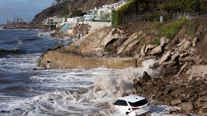
MALIBU, CA - FEBRUARY 14: A fire department vehicle gets covered in waves on Friday, Feb. 14, 2025 in Malibu, CA after it got washed over a cliff in the 19600 block of Pacific Coast Highway during Thursday's storm. The driver survived. (Myung J. Chun / Los Angeles Times via Getty Images)
(Getty Images)
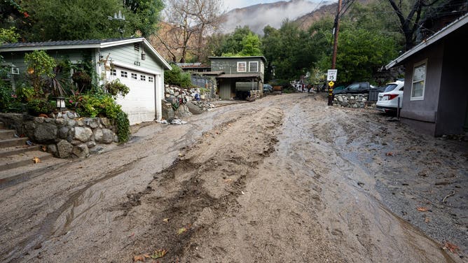
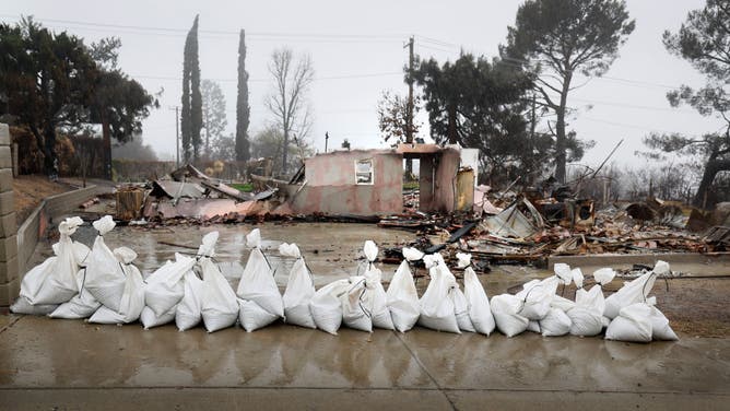
For residents already dealing with the aftermath of the fires, the mudflows were just adding to the woes.
"Seeing these compounding effects of the rain, plus the soot. When you combine that together, it’s not a great combination. It makes it just that much worse," Palisades resident Michael Fanous told FOX 11. "People haven’t been able to go assess their homes… and more damage is sort of affecting their homes as it stands right now."

Mudslides from atmospheric river close Pacific Coast Highway in Malibu, California
The Pacific Coast Highway along Malibu canyon was closed after runoff pushed mud and debris over the road and into the Pacific Ocean (Video Credit: @PIOErikScott).
Other water rescues are reported to have taken place throughout Southern California, but there were no reports of significant injuries from the wet weather event.
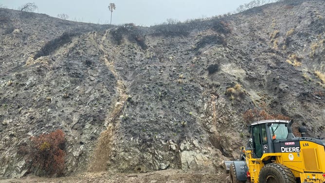
"After the fire occurs and there's so much damage and mobile, loose debris, it doesn't take a whole lot of rain to trigger the downward motion down steep terrain of all that debris," said Ariel Cohen with the National Weather Service office in Los Angeles. "It can potentially become a surging, raging torrent of debris in a matter of minutes."
WIDE SWATH OF US BRACES FOR WEEKEND TRIPLE THREAT OF SEVERE STORMS, FLOODS AND SNOW
The atmospheric river even brought severe thunderstorms to the Los Angeles area with torrential rains, lightning and wind gusts in excess of 60 mph.
According to the FOX Forecast Center, it has been nearly a year since the region had been under a Severe Thunderstorm Warning, as storms generally worked from northwest to southeast across the region.
WEEKEND WINTER STORM TO BRING HEAVY SNOW TO NORTHEAST, SEVERE WEATHER TO SOUTH

MALIBU, CA - FEBRUARY 14: Mud covers the parking lot at Duke's restaurant on Pacific Coast Highway in Malibu, CA on Friday, Feb. 14, 2025.
(Getty Images)
Several mobile homes were reported to be damaged northwest of Los Angeles in Ventura County during the severe weather.
NWS meteorologists will likely survey the damage to determine if a weak tornado was the cause of the wind problems.
Storm triggers urban flooding rescues in Northern California
North of San Francisco, rockslides closed parts of US Highway 101 in Marin County late Thursday evening.
Cars were abandoned on the streets in Fresno on Thursday night after significant urban flooding.

Road flooding in Fresno, California after atmospheric river dumps rounds of rain
Road flooding in Fresno, California after atmospheric river dumps rounds of rain (Video Credit: Nicole DiBuduo Linder via Storyful).
San Jose firefighters had to perform a water rescue to reach two people and six dogs who were stranded Thursday night on an island on the Guadalupe River.
The Santa Cruz Sheriff's Office issued an order for some areas east of Watsonville, California, to evacuate immediately due to a threat from runoff just after 8 a.m. local time. Several roads were closed in the area due to flooding.
20-30 VEHICLES COLLIDE IN WHITEOUT CONDITIONS ALONG MAJOR NORTHWEST FREEWAY
![]() Image 1 of 19
Image 1 of 19Sierra Madre, CA - February 14:As the clouds begin to clear in the mountains were the Eaton fire burned a mudslide was left in the wake of the storm along Sunnyslope Drive in Sierra Madre on Friday, February 14, 2025. Over an Inch of rain fell Thursday over mountain areas burned by the Eaton fire causing several mudslides in the area. (Photo by David Crane/MediaNews Group/Los Angeles Daily News via Getty Images) ( )
![]() Image 2 of 19
Image 2 of 19Sierra Madre, CA - February 14:A mudslide poured into this home along Sunnyslope Drive in Sierra Madre during heavy rains on Thursday. Over an Inch of rain fell Thursday over mountain areas burned by the Eaton fire causing several mudslides in the area. (Photo by David Crane/MediaNews Group/Los Angeles Daily News via Getty Images) ( )
![]() Image 3 of 19
Image 3 of 19MALIBU, CA - FEBRUARY 14: A fire department vehicle gets covered in waves on Friday, Feb. 14, 2025 in Malibu, CA after it got washed over a cliff in the 19600 block of Pacific Coast Highway during Thursday's storm. The driver survived. (Myung J. Chun / Los Angeles Times via Getty Images) ( )
![]() Image 4 of 19
Image 4 of 19MALIBU, CA - FEBRUARY 14: A fire department vehicle gets covered in waves on Friday, Feb. 14, 2025 in Malibu, CA after it got washed over a cliff in the 19600 block of Pacific Coast Highway during Thursday's storm. The driver survived. (Myung J. Chun / Los Angeles Times via Getty Images) ( )
![]() Image 5 of 19
Image 5 of 19MALIBU, CA - FEBRUARY 14: A fire department vehicle gets covered in waves on Friday, Feb. 14, 2025 in Malibu, CA after it got washed over a cliff in the 19600 block of Pacific Coast Highway during Thursday's storm. The driver survived. (Myung J. Chun / Los Angeles Times via Getty Images) ( )
![]() Image 6 of 19
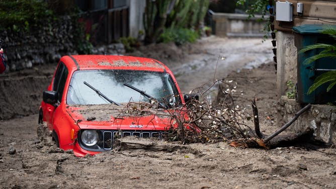
Image 6 of 19Sierra Madre, CA - February 14:This Jeep was buried in mud along Sunnyslope Drive during heavy rains on Thursday. Over an Inch of rain fell Thursday over mountain areas burned by the Eaton fire causing several mudslides in the area. (Photo by David Crane/MediaNews Group/Los Angeles Daily News via Getty Images) ( )
![]() Image 7 of 19
Image 7 of 19Caustic black water from the Eaton Fire rushes by in the Eaton Wash near Altadena, California, as an atmospheric river bring heavy rains on February 13, 2025. Residents of southern Californians are evacuating their homes because of the heavy rain and debris flows that threaten mudslides in areas recovering from wildfires. (Photo by David Swanson / AFP) (Photo by DAVID SWANSON/AFP via Getty Images) ( )
![]() Image 8 of 19
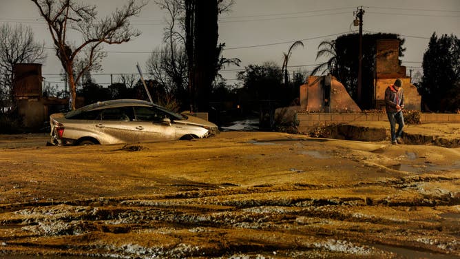
Image 8 of 19ALTADENA, CA - FEBRUARY 13, 2025: Heavy rains created a mud filled debris flow sending cars down Tanoble Drive onto Mendocino Street in the Eaton fire burn area on February 13, 2025 in Altadena, California. (Gina Ferazzi / Los Angeles Times via Getty Images) ( )
![]() Image 9 of 19
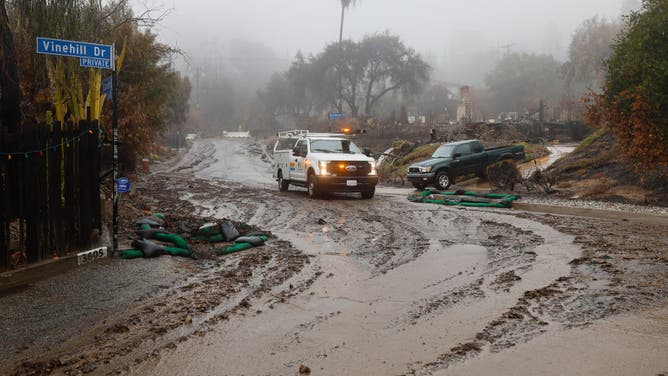
Image 9 of 19Altadena, CA - February 13: Los Angeles County Public Works check on mud and debris flowing down Canon Blvd. at Vinehill Dr. in Altaden as they prepare for flooding and debris flow in the rain in the Eaton fire burn zone in Altadena Thursday, Feb. 13, 2025. A potentially dangerous storm is bearing down on the Southland, prompting evacuation warnings in multiple areas today amid fears that steady downpours could spark flooding, mudslides and debris flows. The brunt of the storm is expected to hit the Los Angeles area around mid-afternoon Thursday, about three to six hours earlier than previous predictions. Photo taken in Altadena Thursday, Feb. 13, 2025. ( )
![]() Image 10 of 19
Image 10 of 19ALTADENA, CA - FEBRUARY 13, 2025: A vehicle is trapped in more than two feet of mud after being carried in the mud filled debris flow down Tanoble Drive onto Mendocino Street in front of two destroyed homes from the Eaton fire on February 13, 2025 in Altadena, California. ( )
![Flood warning in Eaton fire area]() Image 11 of 19
Image 11 of 19ALTADENA, CA - FEBRUARY 13: A small debris and mud flow on Alta Loma Drive in Altadena, CA during a rainstorm over the Eaton fire burn area on Thursday, Feb. 13, 2025. Officials and residents fear much larger and more damaging flows. (Myung J. Chun / Los Angeles Times via Getty Images) (Myung J. Chun / Los Angeles Times via Getty Images)
![Crews monitor the rain in the Eaton fire burn zone where a potentially dangerous storm is bearing down on the Southland, prompting evacuation warnings in multiple areas today amid fears that steady downpours could spark flooding, mudslides and debris flows]() Image 12 of 19
Image 12 of 19Altadena, CA - February 13: Los Angeles County Public Works check on mud and debris flowing down Canon Blvd. at Vinehill Dr. in Altaden as they prepare for flooding and debris flow in the rain in the Eaton fire burn zone in Altadena Thursday, Feb. 13, 2025. A potentially dangerous storm is bearing down on the Southland, prompting evacuation warnings in multiple areas today amid fears that steady downpours could spark flooding, mudslides and debris flows. The brunt of the storm is expected to hit the Los Angeles area around mid-afternoon Thursday, about three to six hours earlier than previous predictions. Photo taken in Altadena Thursday, Feb. 13, 2025. (Allen J. Schaben / Los Angeles Times via Getty Images) (Allen J. Schaben / Los Angeles Times via Getty Images)
![A portion of the Pacific Coast Highway between Malibu and Santa Monica is closed until at least Friday due to mudslides and flooding.]() Image 13 of 19
Image 13 of 19A portion of the Pacific Coast Highway between Malibu and Santa Monica is closed until at least Friday due to mudslides and flooding. (@CaltransDist7/X)
![A portion of the Pacific Coast Highway between Malibu and Santa Monica is closed until at least Friday due to mudslides and flooding.]() Image 14 of 19
Image 14 of 19A portion of the Pacific Coast Highway between Malibu and Santa Monica is closed until at least Friday due to mudslides and flooding. (@CaltransDist7/X)
![A portion of the Pacific Coast Highway between Malibu and Santa Monica is closed until at least Friday due to mudslides and flooding.]() Image 15 of 19
Image 15 of 19A portion of the Pacific Coast Highway between Malibu and Santa Monica is closed until at least Friday due to mudslides and flooding. (@CaltransDist7/X)
![A portion of the Pacific Coast Highway between Malibu and Santa Monica is closed until at least Friday due to mudslides and flooding.]() Image 16 of 19
Image 16 of 19A portion of the Pacific Coast Highway between Malibu and Santa Monica is closed until at least Friday due to mudslides and flooding. (@CaltransDist7/X)
![]() Image 17 of 19
Image 17 of 19Altadena, CA - February 13: Sandbags are placed in front of a burned down house to protect the property from mud and debris flowing along E. Loma Alta Drive as crews prepare for flooding and debris flow in the rain in the Eaton fire burn zone in Altadena Thursday, Feb. 13, 2025. A potentially dangerous storm is bearing down on the Southland, prompting evacuation warnings in multiple areas today amid fears that steady downpours could spark flooding, mudslides and debris flows. The brunt of the storm is expected to hit the Los Angeles area around mid-afternoon Thursday, about three to six hours earlier than previous predictions. ( )
![]() Image 18 of 19
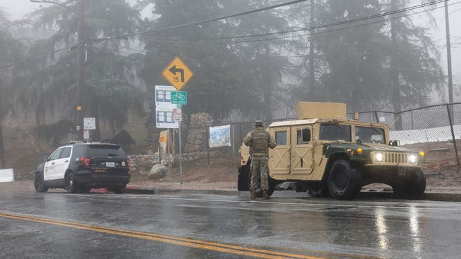
Image 18 of 19Altadena, CA - February 13: A Los Angeles County Sheriff's deputy and California National Guard monitor the hillsides in the rain as crews prepare for flooding and debris flow in the Eaton fire burn zone in Altadena Thursday, Feb. 13, 2025. A potentially dangerous storm is bearing down on the Southland, prompting evacuation warnings in multiple areas today amid fears that steady downpours could spark flooding, mudslides and debris flows. The brunt of the storm is expected to hit the Los Angeles area around mid-afternoon Thursday, about three to six hours earlier than previous predictions. Photo taken in Altadena Thursday, Feb. 13, 2025. (Allen J. Schaben / Los Angeles Times via Getty Images) ( )
![]() Image 19 of 19
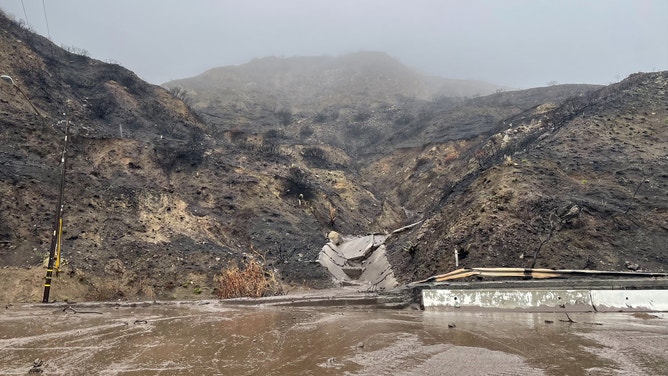
Image 19 of 19Mud and boulders cover a road near the Palisades Fire zone, in the aftermath of a storm in the Pacific Palisades neighborhood of Los Angeles, California, on February 14, 2025. A monster rainstorm was drenching southern California on February 13, 2025, with officials in Los Angeles readying for flooding and landslides in areas burned by last month's huge wildfires. Heavy rain was falling across a swath of the state, with as much as six inches (15 centimeters) expected in some places, forecasters from the National Weather Service (NWS) said. (Photo by AGUSTIN PAULLIER / AFP) (Photo by AGUSTIN PAULLIER/AFP via Getty Images) ( )
Near Dublin, the California Highway Patrol reported two interstate closures due to flooding. Southbound Interstate 680 to Westbound Interstate 580 was closed due to water on the roadway.
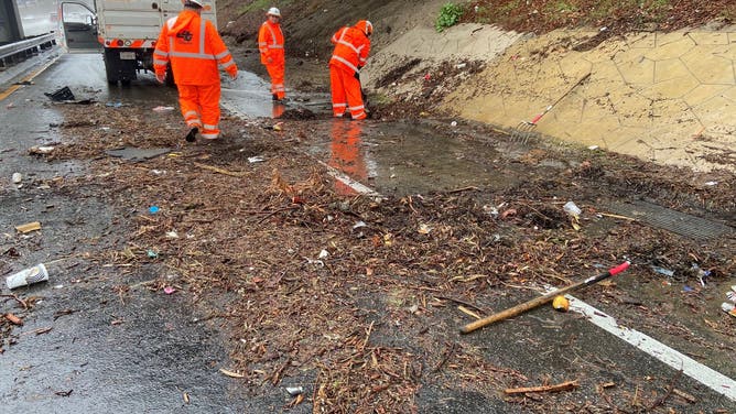
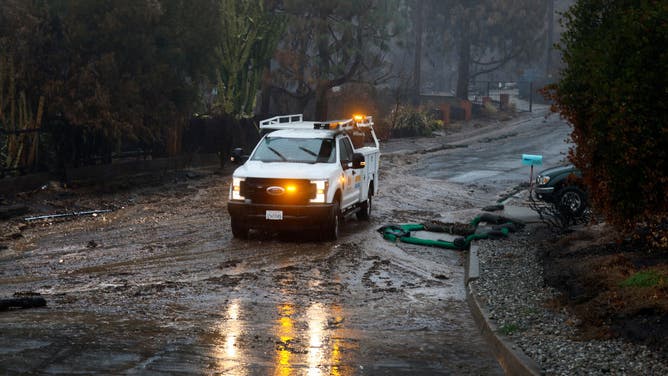
CALTRANS crews work to remove debris from a drain on a road in North Hollywood.
(@CaltransDist7/X / FOX Weather)
Rain is tapering off Friday for much of the state as the storm pushes off to the east and an extended dry stretch is in the offing for next week.
Feet of snow across Sierra, ice storm for Pacific Northwest
A winter storm has been unfolding at higher elevations since Wednesday night. A Winter Storm Warning is in place for the Sierra and White mountains through Friday night.
Travel could be difficult through Friday with feet of snow and gusty winds up to 60 mph. Chain controls are in effect for most of the mountain passes, including I-80 to the Nevada state line.
There were whiteout driving conditions on the Donner Summit Pass along Interstate 80 near Truckee, California on Thursday. Conditions briefly halted traffic in both directions.
WINTER STORM BLASTS PACIFIC NORTHWEST, LEADING TO CHAOS ON MULTIPLE HIGHWAYS AROUND PORTLAND

Whiteout conditions at high elevations in California caused by atmospheric river
Whiteout driving conditions on the Donner Summit Pass along Interstate 80 near Truckee, California. An atmospheric river caused these conditions on Thursday briefly halted traffic in both directions (Video Credit: CHP_Truckee/X).
The forecast shows up to 7 feet of snow in the Sierra Nevada by the weekend.

(FOX Weather)
Farther north, more than 1 million people remain under ice storm warnings in Oregon as the system brought more of a winter storm punch to the Portland area.
Across the West, the storm will wind down on Friday as it treks east, transforming into a winter storm for the eastern U.S.