Crippling winter storm to deliver dangerous ice across massive swath of Southeast, threatening power grids
Winter Storm Watches are now in effect across most of Tennessee and northern Alabama as over 30 states, stretching from western Texas into the Carolinas, could see ice from Friday into the beginning of next week.

Crippling winter storm threatens Southeast with damaging ice and snow
A powerful winter storm targets the Southeast this weekend, bringing crippling ice and significant snow as arctic air locks in. Travel could become extremely hazardous. Stay with FOX Weather for the latest updates on this major storm:
A major winter storm is forecast to move into the Southeast at the start of the weekend, bringing crippling ice and significant snowfall to millions from Mississippi through Tennessee, Georgia and the Carolinas.
Millions of Americans will face the impact of the major winter storm, as heavy snow and crippling levels of ice threaten dangerous travel conditions and widespread power outages.
Winter Storm Watches are now in effect across most of Tennessee and northern Alabama due to the threatening conditions.
Cities in these alerts include Memphis and Nashville, Tennessee and Huntsville, Alabama.
Snow is expected to quickly spread across the South, with the heaviest north of I-40, while significant icing is expected farther south.

As cold air is pushed in from the North could line up with a brewing upper-level disturbance packing enough moisture to deliver a major winter storm this weekend.
(FOX Weather)
Over 30 states stretching from western Texas into the Carolinas could see ice from Friday into the beginning of next week.
The current forecast suggests a classic set-up for a disruptive ice storm in this large corridor.
With dangerous levels of ice threatening millions of Americans, slipping on the way out the door is not the only major concern.

This graphic displays the ice forecast Friday to Monday.
(FOX Weather / FOX Weather)
Major interstates, including I-20, I-40, and I-95, are likely to experience significant icing, leading to dangerous travel conditions.
By late Saturday afternoon, a more significant icing threat could set up along the eastern side of the Appalachians, as a strong area of high pressure system parked north of the Northern Plains and Midwest will continue to funnel in Arctic air.
According to the FOX Forecast Center, some of the coldest air could be trapped, thus setting up a shallow cold layer, better known as cold air damming, which will set the stage for freezing rain.
Atlanta, Augusta, and Charlotte all look to be a part of this threat.

This graphic displays the impacts different amounts of ice have.
(FOX Weather)
By the end of the event, ice accumulations are expected to range from 0.25 to 0.50 inches from northern Alabama through North Carolina.
Areas from Atlanta through Columbia and Raleigh could see 0.50 inches or more of ice, which would be crippling to power infrastructure and travel, with widespread power outages possible in these regions.
Major interstates, including I-20, I-40, and I-95, are likely to experience significant icing, leading to dangerous travel conditions.
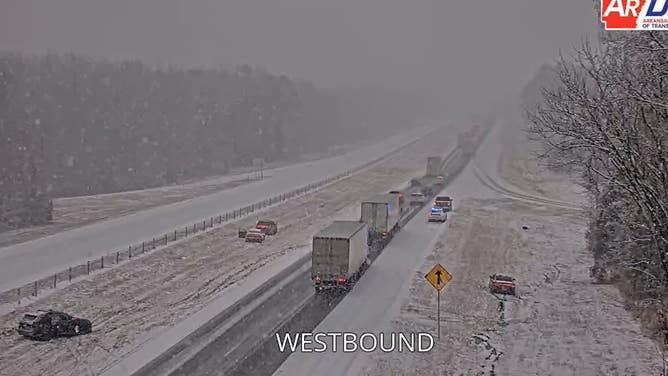
DOT camera shows spinouts on Interstate 40 in Menifee, Arkansas on Jan. 9, 2025.
(Arkansas DOT / FOX Weather)
The highest snowfall totals from Friday through Monday are expected from Nashville through western North Carolina, including Winston-Salem, where over a foot of snow is likely in these areas, as colder air will favor a predominantly snow-driven event.
With the arctic invasion well underway bringing Alaska-like temperatures to several states in the Lower 48, snow and ice will stick around in affected areas in the Southeast.
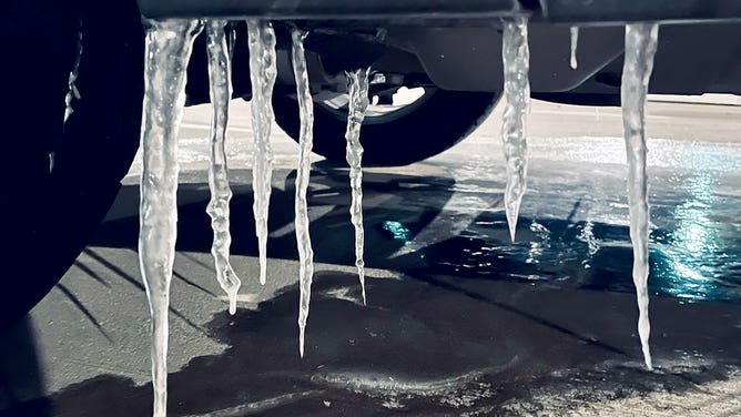
Large icicles form on a car in Houston, Texas, on Feb. 14, 2021.
(Aaron Barker/FOX Weather)
THE GREAT TEXAS FREEZE BEGAN AND WOULD RANK AMONG WORST WINTER STORMS IN HISTORY
Temperatures across the region will remain cold into early next week, meaning much of the snow and ice that falls will persist and complicate recovery efforts.