Daily Weather Update from FOX Weather: First of back-to-back winter storms wreaks havoc on Northeast commute
Top weather news for Thursday, Feb. 6, 2025: The Northeast is grappling with a messy Thursday morning commute as the first in a pair of winter storms coats the region in snow, sleet and freezing rain. On the warm side of this system, flooding and severe weather are impacting the Ohio Valley and central Appalachians.
Weather in America: February 6, 2025
FOX Weather has you covered with the breaking forecasts and weather news headlines for your Weather in America on Thursday, February 6, 2025. Get the latest from FOX Weather Meteorologist Britta Merwin.
Welcome to the Daily Weather Update from FOX Weather. It’s Thursday, Feb. 6, 2025. Start your day with everything you need to know about today's weather. You can also get a quick briefing of national, regional and local weather whenever you like with the FOX Weather Update podcast.
Northeast grapples with icy winter storm causing morning havoc on roads
New York City and the surrounding Northeast region are facing a messy morning commute as a winter storm brings a mix of snow, sleet and freezing rain.
The storm, which began as snow before transitioning to sleet and then freezing rain in some areas, created hazardous conditions for drivers and pedestrians alike Thursday.
The storm's impact varies across the region. While New York City is primarily seeing sleet and some snow, areas north and west, like New England and the Hudson Valley, could see several inches of snow.

(FOX Weather)
Warm side of winter storm spawns flash flooding, tornadoes in West Virginia, Kentucky
A dangerous and life-threatening situation is unfolding in portions of West Virginia as officials urge residents in many communities to seek higher ground immediately after forecasters issued a rare Flash Flood Emergency for the Huntington area on Thursday morning.
There have been several reports of high-water rescues in the Huntington area, and several rockslides have also been reported across the region.
To the west, severe weather and thunderstorms have been sweeping across the region, prompting forecasters to issue a Tornado Watch for a large portion of Kentucky until 11 a.m. ET.
Life-threatening flood threat continues in West Virginia
A rare Flash Flood Emergency was issued for portions of West Virginia early Thursday morning as thunderstorms and torrential rain barreled across the region. Officials in several communities have told residents to seek higher ground as water continues to rise. FOX Weather Meteorologists Britta Merwin and Craig Herrera have the latest.
Weekend winter storm eyes same Midwest, Northeast cities already hit this week
Just as the Midwest and Northeast grapple with an ongoing winter storm, an even stronger one is on its way this weekend. Freezing rain is again a concern for many areas, but the major difference will be significantly heavier snowfall.
The storm will reach the Northeast on Saturday night and produce another round of snow, sleet and freezing rain. The FOX Forecast Center said that, much like the first storm, Pennsylvania appears to be in the bull's-eye for highly impactful ice once again.
Across New England, heavy snow will fall through the first half of Sunday. There is a high probability of more than 6 inches for areas generally north of New York City.

(FOX Weather)
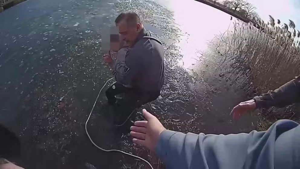
Watch this: New Jersey police officer jumps into icy lake to save 11-year-old boy
An 11-year-old boy was rescued on Monday after he fell through the ice of a frozen lake in northern New Jersey.
Police bodycam footage shows the rescue, which occurred in Franklin Lake in the town of West Long Branch.
In the video, the child appears in the distance in the middle of the icy lake. While the lake is shallow enough for the boy to stand in it, the temperature of the water was estimated to be about 35 degrees, preventing him from freeing himself.
New Jersey police officer jumps into icy lake to save 11-year-old boy
Police bodycam footage shows the rescue of an 11-year-old boy from a lake that had partially frozen over in northern New Jersey on Monday.
Before you go
Here are a few more stories you might find interesting.
- Third Pacific storm to slam California this week with heavy rain, mudslides
- Chances increase of an asteroid impacting Earth in 2032 – but there is no need for panic
- Community south of Los Angeles sinking towards Pacific Ocean
Need more weather? Check your local forecast plus 3D radar in the FOX Weather app. You can also watch FOX Weather wherever you go using the FOX Weather app, at FOXWeather.com/live or on your favorite streaming service.
It’s easy to share your weather photos and videos with us. Email them to weather@fox.com or add #FOXWeather to your post on your favorite social media platform.


