Northeast braces for severe weather, flooding as deadly Debby treks north
NOAA’s Weather Prediction Center placed nearly 10 million people from Pennsylvania to Vermont in a Level 3 out of 4 flood risk on Friday. The Level 3 zone includes cities such as Scranton in Pennsylvania, Syracuse, Binghamton and Albany in New York and Burlington in Vermont.

Debby continues to move toward the Northeast
Debby brings a significant flooding threat for the Northeast, with some parts under a tornado threat. Aug. 8, 2024.
BURLINGTON, Vt. – Millions of people across the waterlogged Northeast are bracing for rounds of severe weather and potentially life-threatening flooding on Friday as Debby begins its trek to the north after making its second U.S. landfall early Thursday morning.
The deadly, slow-moving storm made its first landfall along Florida’s Big Bend region early Monday morning as a Category 1 hurricane.
TRACKING DEBBY: FORECAST CONE, PATH, LIVE CONDITIONS, RAINFALL TOTALS AND MORE

Hurricane Debby's storm surge rocks Florida's Cedar Key
Hurricane Debby approached Florida's Big Bend area as a Category 1 storm Monday morning. Early footage from Cedar Key illustrates the significant threat of storm surge from this tropical cyclone.
After the first landfall, Debby slowed down significantly as it spun across northern Florida and Georgia, eventually making its way into the Carolinas where it dropped feet of rain and triggered countless reports of flooding.
Debby then moved offshore over the open ocean before swinging back toward the East Coast of the U.S., making its second U.S. landfall in South Carolina with winds of about 50 mph.
At least seven people have been killed due to Debby’s impacts, and power was knocked out to hundreds of thousands of utility customers across the Southeast.
Significant flood risk has millions on alert across Northeast, New England

Watch: Exclusive FOX Model Futuretrack shows rain, severe weather slamming Northeast
The exclusive FOX Model Futuretrack shows deep tropical moisture from what's left of Debby pounding the Northeast and New England on Friday.
The FOX Forecast Center said that on Friday, Debby, which will be quickly transitioning from a tropical storm to a post-tropical storm, will be pushing through interior portions of the Northeast.
The extreme amounts of tropical moisture still being produced by the storm, combined with a dip in the jet stream off to the west, are expected to produce heavy precipitation from the central Appalachians through the interior Northeast and northern New England.
This is not good news for many locations, as the region remains extremely saturated from previous rounds of heavy rain over the past several weeks.

(FOX Weather)
Through Sunday, many locations in Pennsylvania and parts of New York state could see an additional 3-5 inches of rain as what's left of Debby races through the region.
Higher rainfall totals are expected farther south, while areas to the north will see lower amounts.
NATIONAL WEATHER SERVICE REVAMPS FLOOD ALERTS

(FOX Weather)
Because of that, NOAA’s Weather Prediction Center (WPC) placed nearly 10 million people from Pennsylvania to Vermont in a Level 3 out of 4 flood risk on Friday.
The Level 3 zone includes cities such as Scranton in Pennsylvania, Syracuse, Binghamton and Albany in New York and Burlington in Vermont.
New York City, which experienced rounds of torrential rain, flooding and severe weather on Tuesday, has been placed in a Level 1 flood threat.
DOWNLOAD THE FREE FOX WEATHER APP

(FOX Weather)
There is also a risk of severe weather on Friday.
NOAA's Storm Prediction Center (SPC) places areas of the U.S. from Virginia to northern New England in a Level 1 out of 5 risk on its 5-point severe thunderstorm risk scale.
This includes cities like Washington, Baltimore, Philadelphia and New York City.
Northeast slammed by recent rounds of heavy rain, severe weather
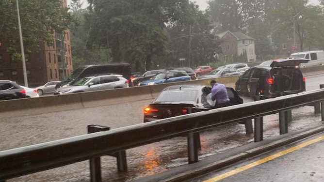
Flash Flood Warning for Manhattan and the Bronx.
(NYC Emergency Management / FOX Weather)
On Tuesday evening, parts of New York City saw intense flooding along highways and roadways after strong thunderstorms moved through the area.
And that was the second day of extreme weather in the Northeast.
On Monday, a waterspout came ashore in downtown Buffalo, New York, and caused damage in the city.

Waterspout comes off Lake Erie into downtown Buffalo
National Weather Service video shows a waterspout coming onshore into downtown Buffalo, New York on Monday ripping part of a roof of a building on Niagara Street.
There were several damaged buildings and traffic lights without power after the twister, but no one was injured, according to police.
After an initial survey, the National Weather Service in Buffalo confirmed the tornado was an EF-1 on the Enhanced Fujita Scale with a maximum wind speed of 90 mph. The twister became a land vortex at Interstate 190 and Niagara Street and ended near Tupper and Oak streets.
Vermont braces for impact after catastrophic flooding in July

Catastrophic flooding impacts Vermont weeks after remnants of Hurricane Beryl
Residents in Lyndonville and St. Johnsbury recount stories of experiencing the latest flood event to impact Vermont.
Farther north, residents in Vermont are holding their breath and hoping for the best after several rounds of catastrophic flooding in July.
Flash Flood Emergencies were issued in Vermont at the end of July after heavy rain forced water from rivers and streams to rush into communities such as St. Johnsbury and Lyndonville.
More than 8 inches of rain was reported in St. Johnsbury in one night, and flooding washed away homes, bridges and roads across the region.