New York City sees significant flooding as Debby's tropical moisture spreads up East Coast
Debby made landfall along Florida's Big Bend region early Monday morning as a Category 1 hurricane, leaving at least five people dead in Florida and Georgia, including children.

Flooding rains blast New York City
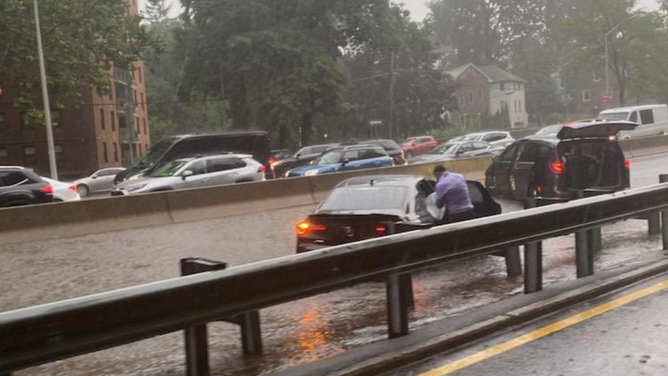
New York City saw strong thunderstorms on Tuesday, flooding several highways across the region.
NEW YORK – Tropical Storm Debby may still be wreaking havoc on the Southeast, but millions of people in the Northeast, including those in New York City and Philadelphia, face a significant flood threat as the deadly storm's tropical moisture spreads up the East Coast of the U.S.
On Tuesday evening, parts of New York City saw intense flooding along highways and roadways after strong thunderstorms moved through the area.
Flash Flood Warning for Manhattan and the Bronx.
(NYC Emergency Management)
Drivers reported seeing standing water on roadways in the Bronx.
The excess moisture from Debby will continue to bring the threat of flooding to New York City through the rest of Tuesday evening.

(FOX Weather)
Debby made landfall along Florida's Big Bend region early Monday morning as a Category 1 hurricane, leaving at least five people dead in Florida and Georgia, including children.
TRACKING DEBBY: FORECAST CONE, PATH, LIVE CONDITIONS, RAINFALL TOTALS AND MORE
The main threats from severe thunderstorms that develop include damaging, hurricane-force wind gusts and ping-pong ball-sized hail, though some tornadoes cannot be ruled out.
Severe weather, flooding likely for millions in Northeast
The FOX Forecast Center said a cold front will be sweeping across the Northeast from the Ohio Valley to southern New England on Tuesday.
As it does so, deep tropical moisture from Debby will be pulled to the north.
The combination of the two means it's going to be an absolute mess up and down the East Coast due to severe thunderstorms and heavy precipitation.
NOAA's Storm Prediction Center (SPC) has highlighted an area of concern from the Ohio Valley to New England, where there's a higher risk of severe weather.
NOAA's Storm Prediction Center (SPC) has a large portion of Pennsylvania in a Level 3 out of 5 risk on its 5-point severe thunderstorm risk scale, including Allentown, Reading and Harrisburg.

(FOX Weather)
Elsewhere, a Level 2 out of 5 threat exists from portions of Indiana through northern Ohio, Pennsylvania, including Philadelphia, and into the New York City tri-state area.
WATCH: WATERSPOUT COMES ASHORE IN DOWNTOWN BUFFALO, NEW YORK
The severe weather threat will be accompanied by a threat of heavy rain, fueled by Tropical Storm Debby's moisture surging hundreds of miles northward, significantly increasing the risk of flash flooding across the Northeast and New England.
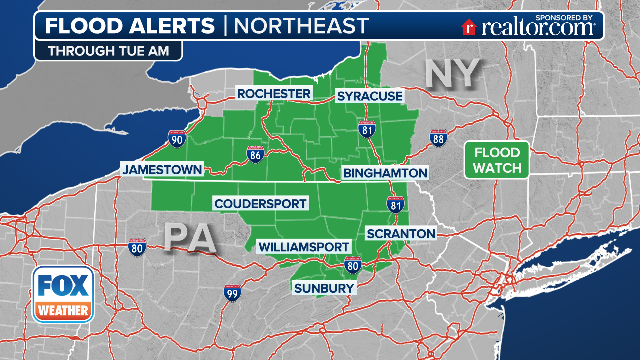
NOAA’s Weather Prediction Center (WPC) has placed areas of the Northeast, including New York City, Philadelphia and Harrisburg in Pennsylvania, in a Level 3 out of 4 risk of flash flooding through Wednesday.
FLOOD WATCH, WARNING AND EMERGENCY: HERE ARE THE DIFFERENCES THAT COULD SAVE YOUR LIFE
(FOX Weather)
The expected heavy rain and thunderstorms prompted the National Weather Service to place millions of people in the Northeast under a Flood Watch through at least Wednesday.
This includes northern Delaware, southeastern Pennsylvania, including Philadelphia, most of New Jersey, New York City and southern Connecticut.

(FOX Weather)
Through Sunday, several inches of rain could fall along the East Coast, with the highest totals centered near and along the Interstate 95 corridor from the mid-Atlantic to the Northeast.
Widespread rainfall totals of 5-8 inches are expected, with locally higher amounts possible where the heaviest rain bands set up.