Debby spawns tornadoes, flooding from South Carolina to Georgia as tropical storm crawls through Southeast
Cities including Savannah, Georgia; Myrtle Beach, South Carolina; and Wilmington, North Carolina, are forecast to see more than a foot of rain through Thursday. Higher totals are possible in places like Charleston, South Carolina, where up to 2.5 feet of rain is not out of the question.

Debby to slowly move up the eastern seaboard
The latest advisory from the National Hurricane Center says Debby has slowed down to 3 mph. As it moves slowly, Debby is expected to draw more energy from the warm Atlantic waters, increasing the flooding potential for the Southeast and Northeast.
CHARLESTON, S.C. – Tropical Storm Debby is threatening coastal Georgia and the Carolinas as it slows down and potentially stalls over the Southeast. The storm could dump more than 2 feet of rain and cause catastrophic flooding.

Watch: Flash flooding continues on Isle of Palms, South Carolina
Flash flooding continues across the South Carolina Low Country and on the Isle of Palms. Tropical Storm Debby is expected to remain near the coast for several days and could drop another 10 inches of rain in some areas. A Flash Flood Watch is in effect until Friday morning.
After making landfall along Florida’s Big Bend on Monday morning as a Category 1 hurricane, Debby is forecast to move slowly northeastward. Debby already dumped more than 20 inches of rain, sent feet of storm surge flooding into Southwest Florida and knocked out power to more than 300,000 customers in Florida at the height of the storm. However, Debby is far from done.
President Joe Biden has declared an emergency exists in Georgia and ordered federal assistance to supplement state and local response efforts due to the emergency conditions caused by Debby.
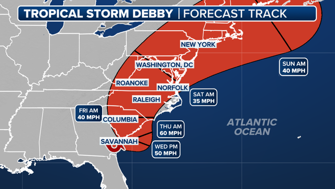
A look at the forecast track for Debby.
(FOX Weather)
NOAA’s Weather Prediction Center has issued a Level 4 flood risk, the highest threat on its scale, for Tuesday, Wednesday and Thursday in parts of southeastern Georgia, eastern South Carolina and southeastern North Carolina. The risk will only slowly shift north each day as Debby slowly meanders near the Southeast coast.
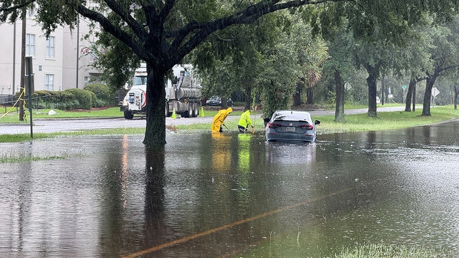
Roads were flooded in Savannah, Georgia on Tuesday afternnon.
(Brandy Campbell / FOX Weather)
Tornadoes wreak havoc in South Carolina
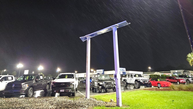
A tornado hit the eastern side of Moncks Corner, South Carolina, on Monday evening. According to the emergency manager for Berkeley County, the tornado destroyed several businesses and damaged many others.

Debby spawns likely tornado in South Carolina
Moncks Corner Mayor Thomas Hamilton joined FOX Weather to talk about the damage caused to his community by a likely tornado. Aug. 6, 2024.
Several trees and power poles were blown down, some of which landed on cars. At least one car was flipped over.
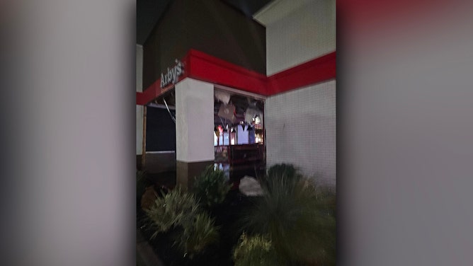
"Roads are opened back up, just be careful in the area of Walmart," Moncks Corner Mayor Thomas Hamilton said on social media. "The Walmart has some roof damage, so not sure when it will open back up. Arby's took the most damage. No major injuries reported, some minor cuts."
![A tornado hit the eastern side of Moncks Corner, South Carolina, on Monday evening.]() Image 1 of 18
Image 1 of 18A tornado hit the eastern side of Moncks Corner, South Carolina, on Monday evening. (Thomas Hamilton)
![A tornado hit the eastern side of Moncks Corner, South Carolina, on Monday evening.]() Image 2 of 18
Image 2 of 18A tornado hit the eastern side of Moncks Corner, South Carolina, on Monday evening. (Thomas Hamilton)
![A tornado hit the eastern side of Moncks Corner, South Carolina, on Monday evening.]() Image 3 of 18
Image 3 of 18A tornado hit the eastern side of Moncks Corner, South Carolina, on Monday evening. (Thomas Hamilton)
![A tornado hit the eastern side of Moncks Corner, South Carolina, on Monday evening.]() Image 4 of 18
Image 4 of 18A tornado hit the eastern side of Moncks Corner, South Carolina, on Monday evening. (Thomas Hamilton)
![A tornado hit the eastern side of Moncks Corner, South Carolina, on Monday evening.]() Image 5 of 18
Image 5 of 18A tornado hit the eastern side of Moncks Corner, South Carolina, on Monday evening. (Thomas Hamilton)
![A tornado hit the eastern side of Moncks Corner, South Carolina, on Monday evening.]() Image 6 of 18
Image 6 of 18A tornado hit the eastern side of Moncks Corner, South Carolina, on Monday evening. (Thomas Hamilton)
![A tornado hit the eastern side of Moncks Corner, South Carolina, on Monday evening.]() Image 7 of 18
Image 7 of 18A tornado hit the eastern side of Moncks Corner, South Carolina, on Monday evening. (Thomas Hamilton)
![A tornado hit the eastern side of Moncks Corner, South Carolina, on Monday evening.]() Image 8 of 18
Image 8 of 18A tornado hit the eastern side of Moncks Corner, South Carolina, on Monday evening. (Thomas Hamilton)
![A tornado hit the eastern side of Moncks Corner, South Carolina, on Monday evening.]() Image 9 of 18
Image 9 of 18A tornado hit the eastern side of Moncks Corner, South Carolina, on Monday evening. (Thomas Hamilton)
![A tornado hit the eastern side of Moncks Corner, South Carolina, on Monday evening.]() Image 10 of 18
Image 10 of 18A tornado hit the eastern side of Moncks Corner, South Carolina, on Monday evening. (Thomas Hamilton)
![A tornado hit the eastern side of Moncks Corner, South Carolina, on Monday evening.]() Image 11 of 18
Image 11 of 18A tornado hit the eastern side of Moncks Corner, South Carolina, on Monday evening. (Thomas Hamilton)
![A tornado hit the eastern side of Moncks Corner, South Carolina, on Monday evening.]() Image 12 of 18
Image 12 of 18A tornado hit the eastern side of Moncks Corner, South Carolina, on Monday evening. (Thomas Hamilton)
![A tornado hit the eastern side of Moncks Corner, South Carolina, on Monday evening.]() Image 13 of 18
Image 13 of 18A tornado hit the eastern side of Moncks Corner, South Carolina, on Monday evening. (Thomas Hamilton)
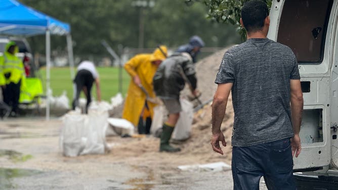
![Residents pack sandbags in Charleston, South Carolina on Monday, August 5, 2024 in preparation for Tropical Storm Debby's winds and rain.]() Image 14 of 18
Image 14 of 18Residents pack sandbags in Charleston, South Carolina on Monday, August 5, 2024 in preparation for Tropical Storm Debby's winds and rain. ( )
![Residents pack sandbags in Charleston, South Carolina on Monday, August 5, 2024 in preparation for Tropical Storm Debby's winds and rain.]() Image 15 of 18
Image 15 of 18Residents pack sandbags in Charleston, South Carolina on Monday, August 5, 2024 in preparation for Tropical Storm Debby's winds and rain. ( )
![Residents pack sandbags in Charleston, South Carolina on Monday, August 5, 2024 in preparation for Tropical Storm Debby's winds and rain.]() Image 16 of 18
Image 16 of 18Residents pack sandbags in Charleston, South Carolina on Monday, August 5, 2024 in preparation for Tropical Storm Debby's winds and rain. ( )
![Residents pack sandbags in Charleston, South Carolina on Monday, August 5, 2024 in preparation for Tropical Storm Debby's winds and rain.]() Image 17 of 18
Image 17 of 18Residents pack sandbags in Charleston, South Carolina on Monday, August 5, 2024 in preparation for Tropical Storm Debby's winds and rain. ( )
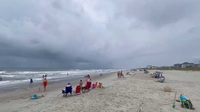
![Storm clouds from Tropical Storm Debby seen from Ocean Isle, North Carolina on Aug. 5, 2024.]() Image 18 of 18
Image 18 of 18Storm clouds from Tropical Storm Debby seen from Ocean Isle Beach, North Carolina on Aug. 5, 2024. (@jedwhitley/X)


Tornado damage could be seen Tuesday morning across Edisto Beach, South Carolina, as Debby moved closer to the area. According to the Colleton County Sheriff's Office, no injuries have been reported, but property damage and several power poles were down.
On Tuesday, Debby continued to dump rain on Parris Island, South Carolina. The U.S. Marine Corps said its recruit depot base in the area is under a shelter-in-place order, which means no one is allowed to move around the base.
And in Isle of Palms, South Carolina, police shared dramatic photos of damage caused by Debby.
The photos show flooded roads and debris after torrential rain and damaging winds moved through the area early Tuesday morning.
Georgia busy with swift water rescues
The Georgia Emergency Management and Homeland Security Agency said state officials conducted swift water rescues Tuesday morning after a car drove into a flooded area in Jeff Davis County.
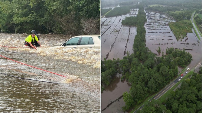
Georgia state officials conducted swift water rescues Tuesday morning in Jeff Davis County after a car drove into a flooded area.
(GEMA/HS)
On Tuesday, the National Weather Service issued several Flash Flood Warnings in southeastern Georgia and eastern South Carolina, where heavy rain will continue to drench the region throughout the day.

(FOX Weather)
DEBBY'S HURRICANE-FORCE WINDS SLAM FLORIDA AT LANDFALL AFTER INTENSIFYING OVER GULF OF MEXICO
Flood Watches are posted from Florida through North Carolina, including Raleigh, through Friday.
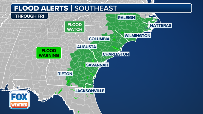
Flood alerts in the Southeast.
(FOX Weather)
Where is Debby heading?
Debby's core is forecast to head out into the Atlantic Ocean on Tuesday, which could allow it to strengthen again, but computer forecast models show it should remain a tropical storm.
Cities including Savannah, Georgia; Myrtle Beach, South Carolina; and Wilmington, North Carolina, are forecast to see more than a foot of rain through Thursday. Higher totals are possible in places like Charleston, South Carolina, where up to 2.5 feet of rain is not out of the question. This could cause possible life-threatening flooding and swell rivers beyond the flood stage.
In addition to the flooding rainfall, tropical-storm-force winds and a few tornadoes are also expected across the Southeast this week.
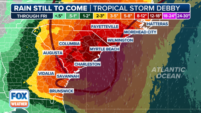
A look at the rain totals from Debby.
(FOX Weather)
South Carolina Gov. Henry McMaster and Georgia Gov. Brian Kemp issued states of emergency ahead of Debby and instructed all residents to prepare for "significant rainfall." Both governors have mobilized National Guard resources to respond to potentially extreme flooding impacts.
North Carolina Gov. Roy Cooper also declared a state of emergency on Monday afternoon.

South Carolina Gov. Henry McMaster speaks about Tropical Storm Debby at the South Carolina Emergency Management Division headquarters on Monday, Aug. 5, 2024.
(Joshua Boucher/The State/Tribune News Service / Getty Images)
On Monday, officials in Chatham County, which includes Savannah, enforced a curfew beginning at 10 p.m.
Flooding timeline for Georgia and the Carolinas
According to the National Hurricane Center (NHC), most computer models show Debby moving off the Southeast U.S. coast by late Tuesday before being pushed back inland over South Carolina on Thursday.

Heavy rainfall continues in Savannah as Tropical Storm Debby stalls
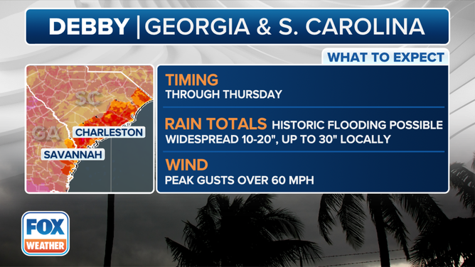
FOX Weather Correspondent Brandy Campbell reports from Savannah, Georgia where the rain has been steady all day as Tropical Storm Debby slowly approaches. The city is expected to see up to 18 inches of rain over several days as extreme flooding is possible.
"Although the details of the track forecast are unknown, there is high confidence that Debby will move slowly while near or over the southeastern U.S., which will likely result in catastrophic flooding in some locations," the NHC said.
The highest rainfall totals are expected through Thursday, with the most rain falling between now and Wednesday.
Debby's impacts on Georgia and the Carolinas.
(FOX Weather)
Savannah could see up to 18 inches of rain, with the most rain falling through Wednesday and peak wind gusts up to 60 mph possible.
Charleston is facing up to 4 feet of storm surge and nearly 2 feet of rain this week, with winds gusting between 40 and 60 mph through Thursday. Myrtle Beach could see gusts up to 60 mph through Tuesday and up to 18 inches of rain by Thursday.
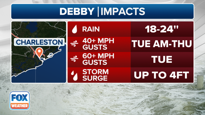
Forecast impacts for Charleston, South Carolina.
(FOX Weather)
"That is unprecedented. That is something that our system, despite having been tested before, that's a level that not enough pumps in the world can address," Charleston Mayor Williams Cogswell said. "It's important for people to take this seriously and to stay home. Be safe. Do not venture out in these floodwaters."