Winter ready to make noise in higher peaks out West as last day of summer arrives
A potent storm system has moved into the western U.S., bringing showers to the Northwest and dropping an early-season chill across the region. It has also ushered in the first Winter Weather Advisories of the season, which are in effect for parts of western Montana and northern Idaho.
Fall front fueling first snowfall of season for parts of West
The first fall storm of the season is on the move and will create a multiday severe weather threat for the central U.S. on Friday, a variety of weather is expected across the western two-thirds of the nation. Widespread showers and a few thunderstorms will impact multiple states, with some of that rain falling as snow in the mountains of Montana, Wyoming and Idaho.
It might be the last day of summer, but winter is ready to make some noise in the higher peaks out West.
A potent storm system has moved into the western U.S., not only bringing some rain, but dropping an early-season chill across the region – enough to talk about some mountain snow as the storm pulls in colder air from Canada.

(FOX Weather)
Snow is expected in the higher peaks of the Northern Rockies for those above 6,000 feet.
Snow has already been spotted for the first time this season on the mountain tops in Jackson Hole, Wyoming. The snow basin in Utah has also transformed into a beautiful winter wonderland. At the Showdown Ski Resort in Montana, it has been snowing since Friday morning and is expected to continue throughout the day.
A large upper low moving through the Rockies has combined with the jet stream overhead and cold air aloft for snow in the higher elevations, no matter what the calendar says.
Winter Weather Advisories have been posted for a few inches of heavy, wet snow and maybe even gusty winds up to 45mph.
"We got Winter Weather Advisories that are posted above 6,000 feet. We have the potential here for several inches. So this is really a travel advisory," FOX Weather meteorologist Britta Merwin said.

(FOX Weather)
Looking at the timeline on the exclusive FOX Model, activity increases Friday afternoon. A few flurries were reported Friday morning, but rain will transition to snow for anyone driving up an elevation as the temperatures drop later in the day.
"By later tonight into (Saturday), we have a good batch of snow over Utah and also Montana, Wyoming and Montana," Merwin said. "This is our next front. It's lining up for Sunday. So we'll watch these fall fronts. How much cold air we have will dictate our chance for snow.
On Saturday, skies will start to clear out with chilly, dry air moving in behind the front. This storm then heads east, to produce severe weather across the Plains.
WHY FALL SHOULD ACTUALLY BEGIN ON SEPTEMBER 1

(FOX Weather)
For the lower elevations, rain will become more widespread across the northern Rockies and northern Plains, creating soggy conditions. Widespread rainfall totals of 1 to 3 inches and a few isolated areas of even higher totals are expected by the end of the weekend.

(FOX Weather)
WHY MAKES LEAVES CHANGE COLOR IN AUTUMN?
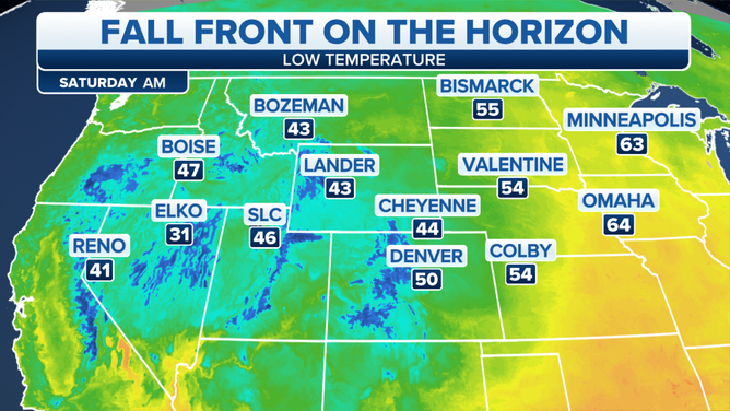
Cooler air arriving behind the front will send some places to their coolest temperatures in months – a real taste of fall as the season officially kicks off on Saturday morning – or late Friday night in the Pacific Time Zone.
Widespread low temperatures in the 40s and even 30s in the higher elevations across much of the West will linger through the weekend.
More severe weather in the Plains into the weekend
Meanwhile, as the cold front continues pressing eastward, it will morph into a renewed severe weather threat into the nation's midsection – also right on time as the start of astronomical fall signals the beginning of the second severe weather season.
FALL IS THE SECOND SEVERE WEATHER SEASON
It appears that ingredients will come together in the Plains to produce severe weather from damaging winds, large hail and potentially a few tornadoes.

(FOX Weather)
"We're looking at (severe weather threats for) Friday, Saturday and Sunday," Morgan said. "The Storm Prediction Center (is) also mentioning that perhaps by Sunday, we could continue with some of the severe weather. So it's left to be seen what exactly we will see with this event."


