Michigan state of emergency expanded as heavy rain and rapid snowmelt fuel Great Lakes flash flooding
Early Thursday, water levels continued to rise to within 6 inches of topping part of the Cheboygan Dam in northern Michigan, after the Little Black River breached a different levee Tuesday, triggering evacuations amid flooding in parts of the downtown.

River flooding prompts evacuation concerns in Michigan areas
Water levels are continuing to rise in some Michigan rivers, with flooding expected to continue through the weekend. FOX Weather Correspondent Katie Byrne is live in Cheboygan, Michigan with the latest:
CHEBOYGAN, Mich. — Dangerous flash flooding is unfolding across parts of Michigan and Wisconsin after days of heavy rain from severe storms and rapid snowmelt have pushed rivers into major flood stages and forced evacuations. Governors of both states have declared states of emergency with more rain still ahead this week.
![]() Image 1 of 11
Image 1 of 11Flooding in Cheboygan, Michigan. ( )
![Rising water levels in Northern Michigan prompted the area near the Richardi Park Dam along with the Peninsula area to temporarily close on April 13.]() Image 2 of 11
Image 2 of 11Rising water levels in Northern Michigan prompted the area near the Richardi Park Dam along with the Peninsula area to temporarily close on April 13. (Village of Bellaire)
![]() Image 3 of 11
Image 3 of 11After the Boardman River swallowed a bridge on Beitner Road near Traverse City on April 14. (Grand Traverse County Road Commission)
![]() Image 4 of 11
Image 4 of 11According to local officials, the popular bridge on Beitner Road sees thousands of travelers a day. (Grand Traverse County Road Commission)
![]() Image 5 of 11
Image 5 of 11The Boardman River at Beitner Road in Traverse City crested at historic levels on April 14, according to the National Weather Service. (Grand Traverse County Road Commission)
![]() Image 6 of 11
Image 6 of 11Snow falling in Marquette, Michigan, on Sunday, March 15, 2026. (Robert Ray)
![]() Image 7 of 11
Image 7 of 11Blizzard conditions seen in Green Bay, Wisconsin, on March 16, 2026. (Brandon Copic)
![]() Image 8 of 11
Image 8 of 11Snow falling in Marquette, Michigan, on Sunday, March 15, 2026. (Robert Ray)
![]() Image 9 of 11
Image 9 of 11Snow falling in Frederic, Michigan, on Sunday, March 15, 2026. (Morgan Stahl)
![Members of the U.S. Coast Guard rescue a stranded snowmobile operator in Michigan.]() Image 10 of 11
Image 10 of 11Members of the U.S. Coast Guard rescue a stranded snowmobile operator in Michigan. (@USCGGreatLakes / X)
![In Marquette, Michigan, on February 18, 2026, as a winter storm warning is announced, heavy snow continues to fall with this winter storm bringing snow, ice, and hazardous conditions across Michigan, where up to 15 inches of snow are expected.]() Image 11 of 11
Image 11 of 11In Marquette, Michigan, on February 18, 2026, as a winter storm warning is announced, heavy snow continues to fall with this winter storm bringing snow, ice, and hazardous conditions across Michigan, where up to 15 inches of snow are expected. (Jerome Gilles/NurPhoto )


Early Thursday, water levels continued to rise to within 6 inches of topping part of the Cheboygan Dam in northern Michigan, after the Little Black River breached a different levee Tuesday, triggering evacuations amid flooding in parts of the downtown.
"We are in crisis mode right now," Michigan Governor Gretchen Whitmer said Thursday.
(FOX Weather)
Flooding has also been reported in West-Central Michigan, north of Grand Rapids, as well as parts of Southeast Wisconsin along Lake Michigan, including Milwaukee. Inundation is also ongoing in Central Wisconsin, in and around Madison.
Both Wisconsin Governor Tony Evers and Michigan Gov. Whitmer cited damage from this week's severe weather and flooding as the impetus for disaster declarations. Gov. Whitmer expanded Michigan's state of emergency to include 33 additional counties Wednesday evening.
Several Cheboygan residents told FOX Weather Correspondent Katie Byrne Thursday that they were self-evacuating due to rising water levels — many with snow still peeking out of floodwaters on their driveways.
Neighbors Byrne spoke to Thursday estimated hundreds of homes have already been flooded.

Watch: Drone footage captures massive flooding in Michigan
Drone footage captured by the FOX Flight Team shows the extensive flooding in Cheboygan, Michigan. There is a high probability of a need to evacuate the area as water levels continue to rise.
The Cheboygan County Sheriff's Office warned people living near the dam to be ready to leave at any time Thursday.
Evacuations were ordered Thursday across parts of Newaygo and Oceana counties north of Grand Rapids. Hesperia officials said life-threatening flooding was possible for areas below the Hesperia Dam along the White River after it overflowed the dam's spillway Wednesday.

Hesperia Dam is close to failure as heavy rain and snowmelt fuel floodwaters
The Hesperia Dam in Michigan is inching closer to failure as floodwaters continue to rise. Heavy rain and snowmelt have fueled dangerous conditions across the region. Officials continue to monitor the situation closely.
Newaygo County ordered evacuations along the floodplain below the Croton Dam on the Muskegon River Thursday morning.
In Traverse City, flooding led to the collapse of a bridge Tuesday night that sees thousands of vehicles a day.

Traverse City, Michigan bridge washed out by floodwaters.
(FOX Weather Correspondent Katie Byrne / FOX Weather)
Historic flooding was also reported along the Menominee River near the Wisconsin border with Michigan's Upper Peninsula. Menominee County sheriffs said roads and bridges have been washed out.

Flooding closes Interstate 43 in Milwaukee Wednesday.
(@MilwCoSheriff/X / FOX Weather)
Interstate 43 was completely submerged on the south side of Milwaukee Wednesday night, paralyzing traffic as a rush of fans left the Milwaukee Brewers game. I-43 reopened with residual delays Thursday.
Officials in the state capital of Madison said flooding reached historic levels in parts of the downtown Tuesday night.

Flooding in Madison, Wisconsin, Tuesday.
(City of Madison, Wisconsin Government/Facebook / FOX Weather)
Waupaca County officials said flooding was ongoing Thursday with part of State Highway 54 closed near the city of New London due to river flooding.
More flooding rain expected through Saturday
As temperatures begin to warm up, spring moisture is fueling heavy rain across the Great Lakes, where persistent downpours combined with rapid snowmelt are driving a heightened risk for flash flooding through Saturday.
This past winter brought a historic snowfall to portions of the region, particularly Michigan's Upper Peninsula. Marquette has recorded over 273 inches of snow so far this season, placing it at number two on the all-time record list.
ARCTIC BLAST OVERSPREADS THE MIDWEST AND GREAT LAKES AFTER MONSTER BLIZZARD SLAMS MILLIONS

Snow falling in Marquette, Michigan, on Sunday, March 15, 2026.
(Robert Ray / FOX Weather)
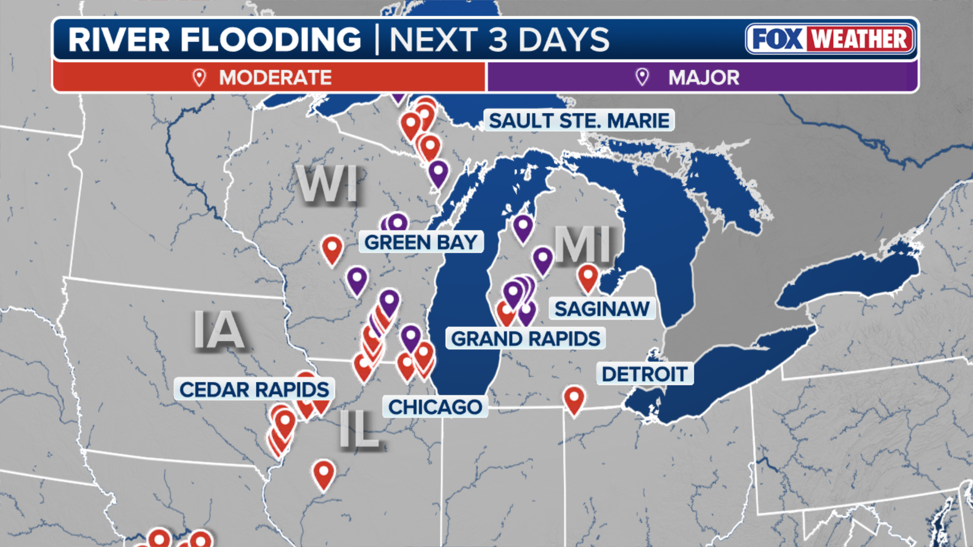
Flood Watches and Warnings for Michigan and southern Wisconsin will be in effect through Thursday.
Numerous rivers and creeks across Wisconsin and Michigan are forecast to reach, or have already reached, major flood stage.

(FOX Weather)
The FOX Forecast Center highlights the stagnant area of high pressure anchored off the Southeast coast as the primary driver behind this week’s flash flood potential acting as a "moisture pump."

(FOX Weather)
An additional widespread 1–2 inches of rain is expected through Saturday.