Dangerous flash flood potential covers part of Gulf Coast on Tuesday before Florida soaker
Rain totals of 3-5 inches are likely along the northern Gulf Coast, with some areas possibly seeing over 6 inches in a short time. The high rain rates could lead to flooding.

Dangerous flash flood threat looms along Gulf Coast on Tuesday
Very heavy rain is falling Tuesday morning from near New Orleans to the Florida Panhandle, and rain totals of 3-5 inches are likely, with some areas possibly seeing over 6 inches in a short time.
NEW ORLEANS – Dangerous flash flooding is a possibility from far eastern Louisiana to the western Florida Panhandle on Tuesday before the system moves into the Florida Peninsula on Wednesday.
Very heavy rain is falling along the Gulf Coast where the National Weather Service in New Orleans issued a Flash Flood Warning in parts of southeastern Louisiana on Tuesday morning.
"That Flash Flood Warning in Baton Rouge does include LSU," FOX Weather Meteorologist Britta Merwin said. "So, if you have students there who're not really familiar with Louisiana, stress to them the importance of not driving."

(FOX Weather)
Rain totals of 3-5 inches are likely, with some areas possibly seeing over 6 inches in a short time. The high rain rates could cause flooding throughout the day.

There's more rain still to come through Wednesday in the Southeast.
(FOX Weather)
Southeast Louisiana, southern Mississippi, Alabama and the Florida Panhandle are the areas at greatest risk.
DOWNLOAD THE FREE FOX WEATHER APP
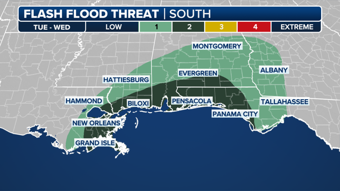
A look at the flash flood threat in the South through Wednesday.
(FOX Weather)
Heavy rain isn't the only issue with this system. As a cold front combines with the remnants of Tropical Storm Sara, there is also a chance for an isolated tornado or two.
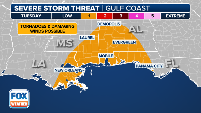
A look at the severe storm threat along the Gulf Coast on Tuesday.
(FOX Weather)
"When you're dealing with this deep, rich, tropical moisture, it allows the thunderstorms to really produce a tremendous amount of rain," Merwin said. "There's not a lot of ton of movement yet, but this cold front will start to move in as it pushes out towards the east. That kind of wrings out the moisture from the atmosphere, dumping it all down to the ground."
It's a short-lived event. As the system moves out, conditions should improve for the northern Gulf Coast by Wednesday, but heavy rain is still likely across the Florida Peninsula.