Catastrophic rain triggers Flood Emergencies, evacuations on fourth straight day of relentless storms Saturday
Torrential rains stalled over southeastern Missouri and the Texarkana region of northeastern Texas and southwestern Arkansas on Friday night and swept into central Arkansas and western Tennessee Saturday, triggering multiple Flash Flood Emergency warnings – the National Weather Service's most dire flooding alert.
Benton, Arkansas, surrounded by floodwaters after Saline River crests at highest level since 2009
FOX Weather Storm Specialist Mike Seidel reports from a flooded Benton, Arkansas, where the Saline River crested at its highest level since December 2009 on Sunday morning. The river is forecast to drop back below flood stage by Sunday night. The nearby city of Little Rock, Arkansas, picked up 11.82 inches of rain, its third-wettest four-day period in 150 years.
MEMPHIS, Tenn. – Life-threatening flooding and dangerous severe weather pummeled large swaths of the nation's heartland again Saturday for the fourth day in a row, leaving some areas with rainfall not seen in generations and triggering evacuations.
Torrential rains stalled over southeastern Missouri and the Texarkana region of northeastern Texas and southwestern Arkansas on Friday night and swept into central Arkansas and western Tennessee Saturday, triggering multiple Flash Flood Emergency warnings – the National Weather Service's most dire flooding alert.
Torrential rains pummel Memphis
A slowly-moving squall line dumped incredible rainfall over Memphis, Tennessee Saturday morning.
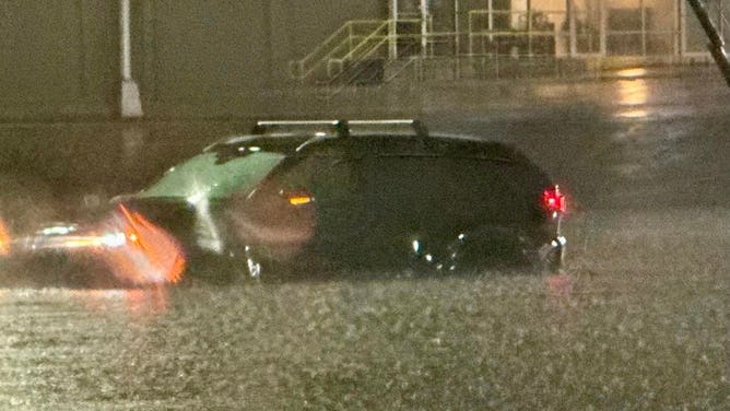
In Memphis, Tennessee, rain falling at rates of over 5 inches an hour quickly overwhelmed streets and neighborhoods on Saturday afternoon, leading to a Flash Flood Emergency. Water rescues were needed in West Memphis, while video from Tennessee's Department of Transportation showed floodwaters swamping parts of Interstate 40.
According to the National Weather Service, 5.47 inches of rain fell at Memphis International Airport on Saturday, marking the city's wettest day ever recorded in April in records dating back to 1872.
The storm drenched Little Rock, Arkansas, earlier in the day, also triggering a Flash Flood Emergency – the first in the city's history. Lightning bolts flashed in rapid succession as thunder boomed multiple times while FOX Weather Storm Specialist Mike Seidel reported from nearby Sherwood.
FLOOD WATCH, WARNING AND EMERGENCY: HERE ARE THE DIFFERENCES THAT COULD SAVE YOUR LIFE
Severe thunderstorm pummels Little Rock area with relentless lightning, torrential rain
FOX Weather's Mike Seidel and photographer Jarrod Maloney were in the thick of a massive thunderstorm as it swept through the Little Rock, Arkansas area Saturday morning, dodging lightning strikes as the NWS issued a Flash Flood Emergency.
There were many reports of trees down across the city as wind gusts reached over 65 mph. Little Rock Air Force Base clocked a gust of 78 mph, and a community center just to the south reported some wind damage. Several miles away to the northeast, portions of Interstate 57 sat under floodwater, the NWS reported.
Farther north, near the Missouri border, several train cars derailed as torrential rains led to swollen rivers that wiped out a bridge in Mammoth Spring State Park.
TRAIN DERAILS IN ARKANSAS AS SWOLLEN RIVER FLOODS BRIDGE IN STATE PARK
Photos from the scene showed multiple train cars toppled and heavily damaged train tracks stretching across the Warm Fork Spring River.

A trail derailed as the Warm Fork Spring River flooded during severe storms on April 5, 2025.
(Donell Russell / FOX Weather)
Over in Missouri, tens of thousands in Cape Girardeau and Van Buren were under flooding emergencies Friday night. Cape Girardeau reported over 3 inches of rain in just over 90 minutes late Friday evening in one burst, with emergency managers reporting at least 10 roads covered in water and multiple water rescues.

Flooding in West Plains, MO
(Missouri Division of Fire Safety / FOX Weather)
Forecasters issued similar dire warnings overnight Friday for Texarkana, Texas, where 2-4 inches of rain fell.
Evacuations ordered in Kentucky
In Kentucky, rising waters forced mandatory evacuations. Pendleton County Emergency Management ordered residents in Falmouth and Butler to leave town by Saturday evening, saying floodwaters would inundate homes and businesses, and city officials couldn't promise utilities would remain functional.
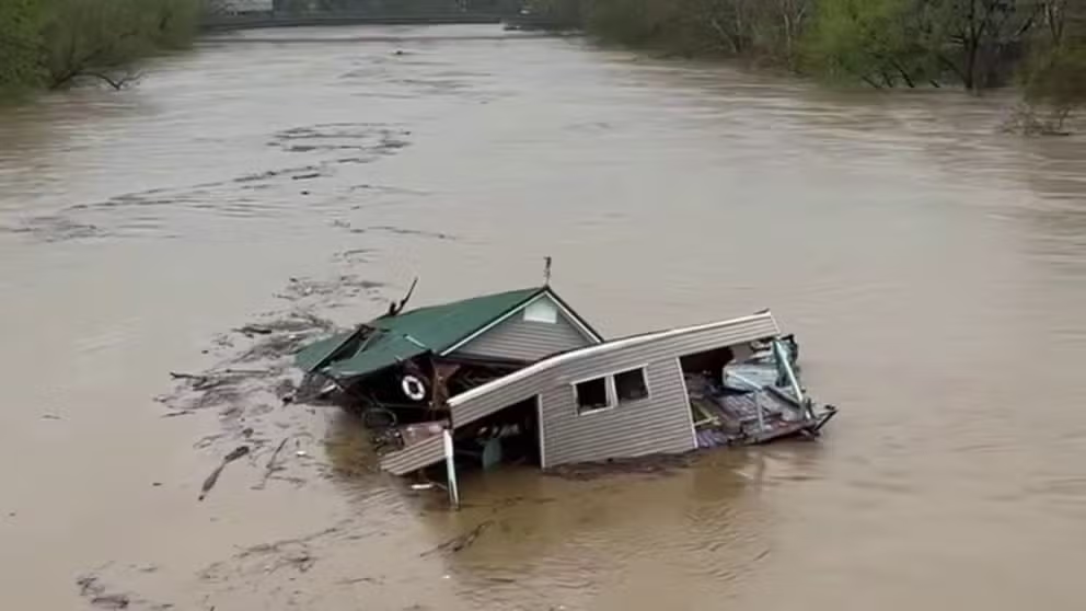
Some of the damage was already apparent in the state as residents in Frankfort saw a damaged home swept up and floating down the swollen Kentucky River.
Building spotted floating down the Kentucky River
A large building was spotted drifting down the Kentucky River between Lexington and Louisville on Saturday, following catastrophic flooding across the Blue Grass State.
SEE IT: BUILDING SPOTTED GETTING SWEPT DOWN SWOLLEN KENTUCKY RIVER
Farther upstream, multiple homes were flooded in Jessamine County. Footage showed at least 10 homes surrounded by floodwaters, with some water rescues underway.
Drone video shows rescuers saving people stranded by Kentucky floods
Some residents in the central Kentucky town of High Bridge became stranded as the nearby Kentucky River surged and flooded their homes. (Courtesy: Neil Noah via Storyful)
Officials in Woodford County ordered evacuations on Saturday due to the Kentucky River flooding. According to NOAA's National Water Prediction Service, the latest forecast shows the river cresting at 49.5 feet on Monday, which would be the highest historical Kentucky River flood on record.
"If you're near the river, and you have any proximity to water, you need to leave," Woodford County Judge Executive James Kay said on Sunday.
Earlier Saturday, officials in Hopkinsville, Kentucky, reported that 60% of their downtown area was underwater.
"It’s destroyed. I can’t salvage anything out of it," said Paul Garrett, a Hopkinsville resident whose home was flooded. "I’ve lived here a long time, and this is the worst I’ve ever seen it. The weather crew has been good about warning us about things. Take it for granted or not, you just wind up at the wrong place at the wrong time."
More than 70,000 customers remained without power in Arkansas and another 32,000-plus were without power in Tennessee as of Sunday morning, according to FindEnergy.com.
WHY IS THIS RELENTLESS SEVERE WEATHER PATTERN STUCK OVER EASTERN HALF OF THE US?
Meanwhile, dozens of Tornado Warnings wailed across northeastern Texas and into the lower Mississippi Valley and parts of the mid-South as a stalled frontal system spawned a renewed round of severe thunderstorms and supercells.
Nashville, Tennessee, was even put under a Tornado Warning on Saturday when winds of 60-80 mph moved through Music City.
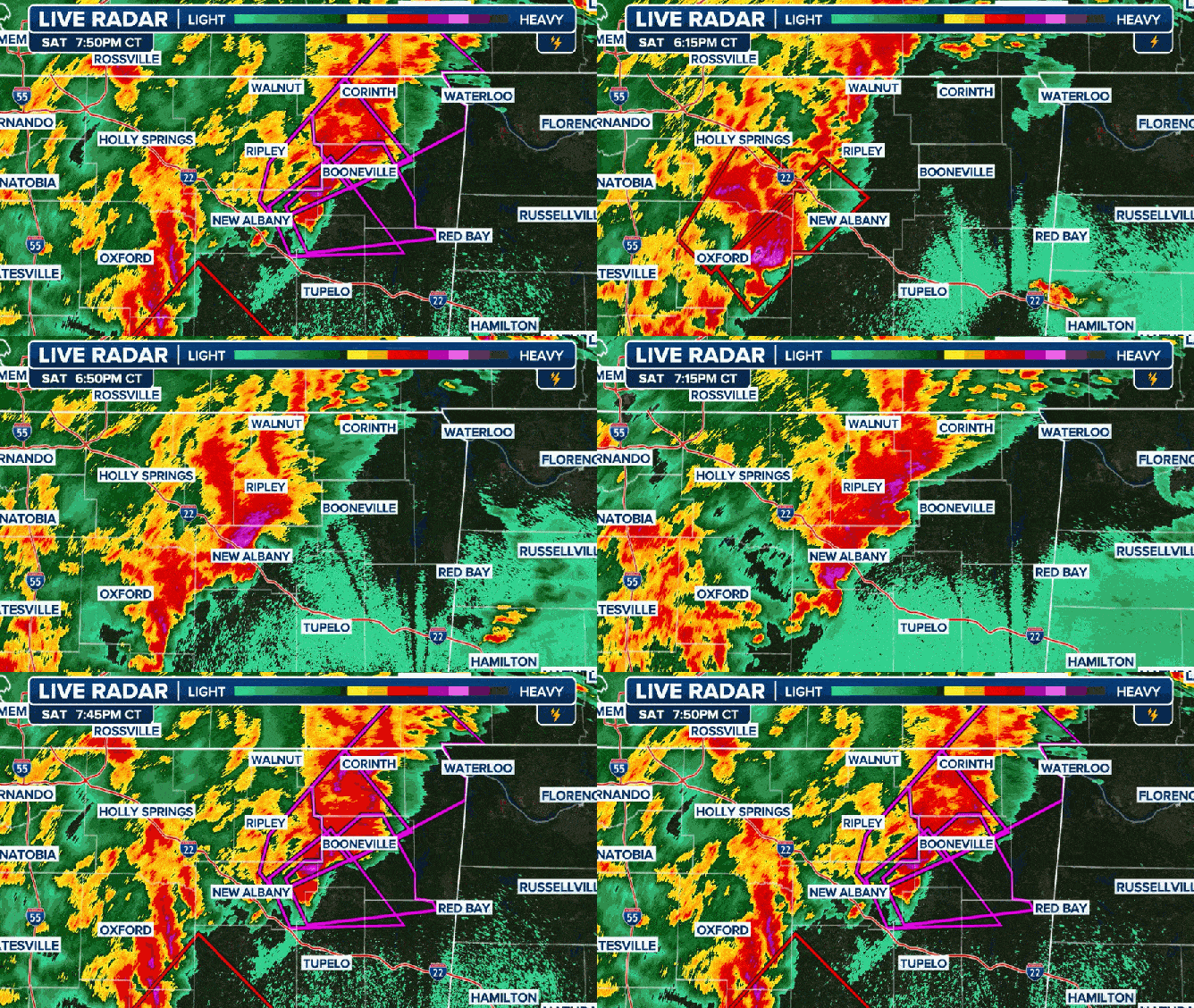
At least one tornado was also spotted in northeastern Mississippi, north of Interstate 22, but extensive damage was not reported following the supercell.
Mississippi Emergency Management Agency (MEMA) officials reported a death that occurred between Saturday and Sunday from the severe weather that struck the state. That person was killed in Jasper County, according to MEMA.

Radar animation from Mississippi from Saturday, April 5, 2025.
(FOX Weather)
More than a dozen people have died from severe weather and flooding events since late last week as a massive storm system remained stuck over the central U.S.
AT LEAST 17 DEAD AS TORNADOES, FLOODING RAVAGE SEVERAL STATES IN CENTRAL US
Weather pattern finally begins to calm Sunday
While some lingering risk of severe storms drifts into the Southeast on Sunday, the threat is considerably lower than the past several days. In addition, the risks of flash flooding are lower and will push off to the east of where most of the heavy rains have fallen for days.
But even long after the rain ends on Sunday, the flood impacts will be far from over. All the water will continue to surge into progressively larger streams and rivers across the region.
These, in turn, will rise through the end of the weekend and even into the week ahead. Houses that did not flood when the rain was falling may find themselves underwater days later.
As the water eventually drains into the Mississippi and Ohio rivers in the days and weeks ahead, some flooding is likely downstream. Waters in Baton Rouge, Louisiana, along the Mississippi River may reach the highest level in four years later this month, according to the FOX Forecast Center.
Relentless severe weather, flash flood threats finally shift east Sunday threatening parts of Southeast
After four straight days with a barrage of persistent severe storms and flooding rainfall for parts of the mid-South and mid-Mississippi Valley, the threat finally shifts east Sunday into portions of the Southeast.


