Atmospheric river event blasts Florida Panhandle with severe weather as state faces heaviest rain since winter
Tornado Warnings wailed across parts of the Florida Panhandle on Saturday, including one tornado near Eucheeanna that was confirmed by radar. Officials in Destin, Florida, reported damage from a possible tornado as severe weather moved through Saturday morning.

Heavy rain and storms are expected to bring drought relief to some areas in Florida.
Florida has been facing its worst drought since 2012, as it has been one of the ten driest years across the state. Areas such as Miami need three to five inches of rain to alleviate around 40% of the drought conditions.
JACKSONVILLE, Fla. – An atmospheric river event is bringing the heaviest rainfall Florida has seen since winter, with widespread downpours expected to continue over the next several days.
Tornado Warnings wailed across parts of the Florida Panhandle on Saturday, including one tornado near Eucheeanna that was confirmed by radar.
Officials in Destin, Florida, reported damage from a possible tornado as severe weather moved through Saturday morning. "Multiple businesses and vehicles were damaged," said officials with the Okaloosa County Sheriff's Office, noting that there were no reports of injuries but dozens of locations were without power.
![Possible tornado in Destin, Florida]() Image 1 of 9
Image 1 of 9Damage from a possible tornado in Destin, Florida on May 10, 2025. (Okaloosa County Sheriff's Office)
![Possible tornado in Destin, Florida]() Image 2 of 9
Image 2 of 9Possible tornado in Destin, Florida (Okaloosa County Sheriff's Office)
![Possible tornado in Destin, Florida]() Image 3 of 9
Image 3 of 9Damage from a possible tornado in Destin, Florida on May 10, 2025. (Destin Fire Dept. )
![Possible tornado in Destin, Florida]() Image 4 of 9
Image 4 of 9Damage from a possible tornado in Destin, Florida on May 10, 2025. (Destin Fire Dept. )
![Possible tornado in Destin, Florida]() Image 5 of 9
Image 5 of 9Damage from a possible tornado in Destin, Florida on May 10, 2025. (Destin Fire Dept. )
![Tornado damage outside of Destin, Florida on 5/10/2025]() Image 6 of 9
Image 6 of 9Tornado damage outside of Destin, Florida on 5/10/2025 (Teresa Allen)
![Possible tornado in Destin, Florida]() Image 7 of 9
Image 7 of 9Damage from a possible tornado in Destin, Florida on May 10, 2025. (Destin Fire Dept. )
![A rain delay at the Tampa Bay Rays game on May, 10, 2025.]() Image 8 of 9
Image 8 of 9A rain delay at the Tampa Bay Rays game on May, 10, 2025. (Matt Leach)
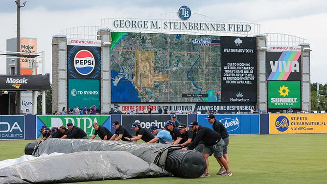
![The Tampa Bay Rays grounds grew rolls up the tarp during the first ever home rain delay in Tampa Bay Rays history prior to a game against the Milwaukee Brewers at George M. Steinbrenner Field on May 10, 2025 in Tampa, Florida.]() Image 9 of 9
Image 9 of 9TAMPA, FLORIDA - MAY 10: The Tampa Bay Rays grounds grew rolls up the tarp during the first ever home rain delay in Tampa Bay Rays history prior to a game against the Milwaukee Brewers at George M. Steinbrenner Field on May 10, 2025 in Tampa, Florida. (Photo by Kelly Gavin/Getty Images) (Kelly Gavin/Getty Images)


In addition to severe weather, computer forecast models show the potential for widespread rainfall, with totals ranging from around an inch in the least-impacted areas to possibly upwards of a foot in communities that see repeated rounds of thunderstorms.
Early Sunday morning, Northwest Florida Beaches International Airport in Panama City picked up a whopping 0.75 inches of rain in just eight minutes between 3:56 a.m. and 4:04 a.m. CT, which is a staggering rainfall rate of 5.63 inches an hour. Panama City's two-hour rainfall total between 3 a.m. and 5 a.m. CT was 2.26 inches.
Flood Watches cover a portion of the Florida Panhandle into southern Georgia and Alabama. Storm spotters in Ocean City, Florida, reported multiple flooded roads after heavy rains pushed through.
Further south, rain delayed Tampa Bay Rays games at Steinbrenner Field on Saturday and Sunday, including the MLB team's first-ever home rain delay.
TAMPA, FLORIDA - MAY 10: The Tampa Bay Rays grounds grew rolls up the tarp during the first ever home rain delay in Tampa Bay Rays history prior to a game against the Milwaukee Brewers at George M. Steinbrenner Field on May 10, 2025 in Tampa, Florida. (Photo by Kelly Gavin/Getty Images)
(Getty Images)
While atmospheric rivers are often associated with winter storms on the West Coast, the phenomenon can occur elsewhere in the U.S. and around the world wherever deep tropical moisture is involved.

It was a dark and gloomy Mother's Day in Florida as heavy rain drenched the area
Heavy rain accompanied by thunder and lightning dampened the big day for those in the South.
The FOX Forecast Center said the system responsible for this surge of precipitation is a low-pressure system that has become cut off from the main jet stream, making it slow-moving and capable of producing prolonged rain.
"When the low pressure is vertically stacked from the floor, all the way to the top of the troposphere, it doesn't really move that fast because nothing's pushing around," FOX Weather Meteorologist Bob Van Dillen said. "That's what we have. And that area of low pressure is going to jack that cold front down and siphon a lot of moisture off the Gulf and the Caribbean too."

(FOX Weather)
Florida won’t be the only state impacted, as a broad swath of heavy precipitation is expected to stretch from Louisiana to the Carolinas, which will last into the first half of the week ahead.
"It’s picking up in intensity, and it's going to be even worse – later on – as we go through the day into Sunday and Monday," Van Dillen stated.
NEW TO FLORIDA? HERE’S WHEN THE SUNSHINE STATE’S RAINY SEASON GETS UNDERWAY
Help on the way for parched state
But for the Sunshine State, the rain could help suppress wildfire activity during what is considered to be the peak of the fire season.
Most rainfall deficits in Florida currently range from 2 to 6 inches, with 96% of the state considered to be unusually dry and 25% experiencing severe drought conditions, according to the latest U.S. Drought Monitor.

(FOX Weather)
The areas expected to receive the most rainfall are along the Interstate 10 corridor, from Pensacola through Tallahassee and Jacksonville.
In contrast, the least amount of rain is expected well south of the Interstate 4 corridor in South Florida.
Unfortunately, that’s where most of the fires have been, with Miami-Dade Fire Rescue recently responding to a large grass fire burning between Florida City and the Florida Keys.
WHERE YOU CAN DITCH THE RAIN AT UNIVERSAL’S EPIC UNIVERSE THEME PARK
So, while the persistent rain will be welcome news, the areas in the most desperate shape may see the least relief.
And of course, any thunderstorms that form have the potential to cause flash flooding and lightning, which can, in some cases, spark new fires.
Still, the ongoing atmospheric river is, overall, just what the doctor ordered and will serve as a reprieve until the state’s wet season kicks in during the next month or so.