New Orleans under tornado threat as Hurricane Francine lashes Gulf Coast
The tornado risk is forecast to steadily increase Wednesday afternoon across southeastern Louisiana before moving the severe weather threat into southeastern Mississippi, southern Alabama and the Florida Panhandle overnight and into Thursday.

Louisiana, Mississippi under Tornado Watch as Hurricane Francine approaches
New Orleans, Gulfport and other cities along the Gulf Coast are under the threat for tornadoes on Wednesday as Hurricane Francine approaches Louisiana. A Tornado Watch is in place through Wednesday night.
NEW ORLEANS – New Orleans and Baton Rouge, Louisiana, are not only facing dangerous storm surge from Hurricane Francine, but the added threat of tornadoes and severe thunderstorms on Wednesday evening and night.
Francine made landfall on the southern Louisiana coast Wednesday evening, bringing a life-threatening storm surge, heavy rain and 100-mph wind gusts.
As Francine moves through, considerable strengthening winds, a northern shift of a warm maritime front and moisture-rich air could result in supercell thunderstorms capable of producing tornadoes. With this dangerous combination, NOAA's Storm Prediction Center (SPC) is highlighting a Level 2 out of 5 risk for severe thunderstorms along the Gulf Coast through Wednesday night.

(FOX Weather)
FRANCINE TRACKER: FORECAST CONE, SPAGHETTI MODELS, LIVE CONDITIONS AND MORE
According to the SPC, the supercell and tornado risk is forecast to steadily increase Wednesday afternoon across southeastern Louisiana before moving the severe weather threat into southeastern Mississippi, southern Alabama and the Florida Panhandle overnight and into Thursday.

(FOX Weather)
The National Weather Service in New Orleans issued a Tornado Watch through Wednesday night for more than a dozen parishes, including Orleans, along the southeastern coast of the Bayou State.
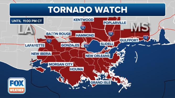
Tornado Watch along Gulf Coast on Sept. 11, 2024.
(FOX Weather)
Cities in the highest risk area include New Orleans, Metairie and Kenner in Louisiana. Mobile, Alabama, and Gulfport, Mississippi, are also in the highlighted risk area.
The severe weather threat will shift north and eastward by Thursday afternoon Francine's remnants move into the southeastern U.S.
(FOX Weather)