Bomb cyclone Eowyn blasts Ireland with record 114 mph gust as 1 million lose power across British Isles
A gust of 114 mph (135 km/hr) recorded at Mace Head on Ireland’s western shores early Friday morning – as strong as a Category 3 hurricane – set the national record for the highest wind gust recorded in the nation, according to Ireland’s national weather service Met Éireann.

Intrepid weather spotter braves 100+ mph winds to get measurements during Storm Eowyn
A determined weather spotter went to Ireland's coast during the brunt of the historic Storm Eowyn to measure its hurricane-force gusts.
DUBLIN, Ireland – A historic windstorm blasted Ireland and the northern stretches of the United Kingdom on Friday with gusts reaching over 100 mph, leaving over 1 million electrical customers without power and wreaking havoc across four nations.
Forecasters have named the storm system Éowyn as it rapidly strengthened in the Northern Atlantic and became what is known as a bomb cyclone. It’s the second continent to bear the brunt of the storm’s energy, which had just three days earlier brought record snows to the U.S. Gulf Coast.

DUBLIN, IRELAND - JANUARY 24: Ice skating rink collapse during the storm Eowyn in Blanchardstown, suburb of Dublin. on January 24, 2025 in Dublin, Ireland. (Photo by Natalia Campos/Getty Images)
(Getty Images)
A gust of 114 mph (135 km/hr) recorded at Mace Head on Ireland’s western shores early Friday morning – as strong as a Category 3 hurricane – set the national record for the highest wind gust recorded in the nation, according to Ireland’s national weather service Met Éireann. The previous record was a 113 mph gust recorded in 1945.
Drumalbin, Scotland, recorded a gust of 100 mph, while Aberdaron, Wales, hit 93 mph and Shannon, Ireland, recorded a gust of 85 mph. In the larger cities, Edinburgh hit a gust of 85 mph, while Belfast hit 71 mph, Glasgow reported a gust of 70 mph and Dublin clocked a gust of 64 mph.
![]() Image 1 of 16
Image 1 of 16HELENSBURGH, SCOTLAND - JANUARY 24: Helensburgh swimming pool roof is damaged during Storm Eowyn on January 24, 2025 in Helensburgh, Scotland, United Kingdom. The Met Office has issued rare red Warnings for wind for Northern Ireland as well as central and southwestern areas of Scotland. These are accompanied by wider Amber and Yellow Warnings for wind, as well as Yellow Warnings for rain and snow across the UK. (Photo by Jeff J Mitchell/Getty Images) ( )
![An ambulance attends the scene of a crash during strong winds on the north bound A19 near to the A690 Durham Road, in County Durham, in the North East of England. Schools have been closed and people warned not to travel on Friday, as 100mph winds pose a danger to life in parts of the UK as Storm Eowyn hits the country. Picture date: Friday January 24, 2025.]() Image 2 of 16
Image 2 of 16An ambulance attends the scene of a crash during strong winds on the north bound A19 near to the A690 Durham Road, in County Durham, in the North East of England. Schools have been closed and people warned not to travel on Friday, as 100mph winds pose a danger to life in parts of the UK as Storm Eowyn hits the country. Picture date: Friday January 24, 2025. (Owen Humphreys/PA)
![Damaged roof at the Chimney Corner Hotel seen in Mallusk, on January 24, 2025 near Belfast, Northern Ireland. The Met Office has issued rare red Warnings for wind for Northern Ireland as well as central and southwestern areas of Scotland. These are accompanied by wider Amber and Yellow Warnings for wind, as well as Yellow Warnings for rain and snow across the UK.]() Image 3 of 16
Image 3 of 16Damaged roof at the Chimney Corner Hotel seen in Mallusk, on January 24, 2025 near Belfast, Northern Ireland. The Met Office has issued rare red Warnings for wind for Northern Ireland as well as central and southwestern areas of Scotland. These are accompanied by wider Amber and Yellow Warnings for wind, as well as Yellow Warnings for rain and snow across the UK. (Charles McQuillan)
![]() Image 4 of 16
Image 4 of 16A photograph taken on January 24, 2025 shows a roof torn off from the Chimney Corner Hotel, outside Belfast, in Co Antrim, in Northern Ireland, as storm Eowyn brings winds of 100 mph to the UK and Ireland. A rare red warning for wind, which warns of "very dangerous conditions" and gusts of up to 100mph, was issued by the Met Office for Northern Ireland and Scotland on Friday. (Photo by PAUL FAITH / AFP) (Photo by PAUL FAITH/AFP via Getty Images) ( )
![]() Image 5 of 16
Image 5 of 16A woman photographs a fallen tree which crashed through the wall of Phoenix Park and on to Blackhorse Avenue in Dublin. Residents across Ireland have been urged to stay at home as the entire island braces for the arrival of Storm Eowyn. The top-level red warning for wind is in place in both Northern Ireland and the Republic of Ireland. Picture date: Friday January 24, 2025. (Photo by Brian Lawless/PA Images via Getty Images) ( )
![]() Image 6 of 16
Image 6 of 16Workers start to remove a fallen tree which crashed through the wall of Phoenix Park and on to Blackhorse Avenue in Dublin. Residents across Ireland have been urged to stay at home as the entire island braces for the arrival of Storm Eowyn. The top-level red warning for wind is in place in both Northern Ireland and the Republic of Ireland. Picture date: Friday January 24, 2025. (Photo by Brian Lawless/PA Images via Getty Images) ( )
![A dog walks past a police car and fallen tree obstructing the road in Helensburgh Scotland on January 24, 2025, as storm Eowyn brings winds of 100 mph to the UK and Ireland. A rare red warning for wind, which warns of "very dangerous conditions" and gusts of up to 100mph, was issued by the Met Office for Northern Ireland and Scotland on Friday.]() Image 7 of 16
Image 7 of 16A dog walks past a police car and fallen tree obstructing the road in Helensburgh Scotland on January 24, 2025, as storm Eowyn brings winds of 100 mph to the UK and Ireland. A rare red warning for wind, which warns of "very dangerous conditions" and gusts of up to 100mph, was issued by the Met Office for Northern Ireland and Scotland on Friday. (ANDY BUCHANAN/AFP)
![Winter weather Jan 24th 2025]() Image 8 of 16
Image 8 of 16Storm Eowyn damage to the side of the Co-op store in Denny, Stirlingshire. Schools have been closed and people warned not to travel on Friday, as 100mph winds pose a danger to life in parts of the UK as Storm Eowyn hits the country. (Jane Barlow/PA)
![Rare Red Weather Warning In Place As Storm Eowyn Becomes First Named UK Storm Of 2025]() Image 9 of 16
Image 9 of 16DUBLIN, IRELAND - JANUARY 24: Ice skating rink collapse during the storm Eowyn in Blanchardstown, suburb of Dublin. on January 24, 2025 in Dublin, Ireland. The Met Office has issued rare red Warnings for wind for Northern Ireland as well as central and southwestern areas of Scotland. These are accompanied by wider Amber and Yellow Warnings for wind, as well as Yellow Warnings for rain and snow across the UK. (Photo by Natalia Campos/Getty Images) ( )
![]() Image 10 of 16
Image 10 of 16UNSPECIFIED, SCOTLAND - JANUARY 24: People walk about in the heavy rain on January 24, 2025 in Helensburgh, Scotland, United Kingdom. The Met Office has issued rare red Warnings for wind for Northern Ireland as well as central and southwestern areas of Scotland. These are accompanied by wider Amber and Yellow Warnings for wind, as well as Yellow Warnings for rain and snow across the UK. (Photo by Jeff J Mitchell/Getty Images) ( )
![Damage to car and a fallen tree through the roof of a house seen during Storm Éowyn on January 24, 2025 in Newtownabbey, Northern Ireland. The Met Office has issued rare red Warnings for wind for Northern Ireland as well as central and southwestern areas of Scotland. These are accompanied by wider Amber and Yellow Warnings for wind, as well as Yellow Warnings for rain and snow across the UK.]() Image 11 of 16
Image 11 of 16Damage to car and a fallen tree through the roof of a house seen during Storm Éowyn on January 24, 2025 in Newtownabbey, Northern Ireland. The Met Office has issued rare red Warnings for wind for Northern Ireland as well as central and southwestern areas of Scotland. These are accompanied by wider Amber and Yellow Warnings for wind, as well as Yellow Warnings for rain and snow across the UK. (Charles McQuillan)
![A fallen tree brought down during Storm Éowyn blocks the road on January 24, 2025 in Holywood, near Belfast, Northern Ireland. The Met Office has issued rare red Warnings for wind for Northern Ireland as well as central and southwestern areas of Scotland. These are accompanied by wider Amber and Yellow Warnings for wind, as well as Yellow Warnings for rain and snow across the UK.]() Image 12 of 16
Image 12 of 16A fallen tree brought down during Storm Éowyn blocks the road on January 24, 2025 in Holywood, near Belfast, Northern Ireland. The Met Office has issued rare red Warnings for wind for Northern Ireland as well as central and southwestern areas of Scotland. These are accompanied by wider Amber and Yellow Warnings for wind, as well as Yellow Warnings for rain and snow across the UK. (Charles McQuillan)
![An ice skating facility in Blanchardstown has been destroyed after strong winds tore the structure apart. Residents across Ireland have been urged to stay at home as the entire island braces for the arrival of Storm Eowyn. The top-level red warning for wind is in place in both Northern Ireland and the Republic of Ireland. Picture date: Friday January 24, 2025.]() Image 13 of 16
Image 13 of 16An ice skating facility in Blanchardstown has been destroyed after strong winds tore the structure apart. Residents across Ireland have been urged to stay at home as the entire island braces for the arrival of Storm Eowyn. The top-level red warning for wind is in place in both Northern Ireland and the Republic of Ireland. Picture date: Friday January 24, 2025. (Brian Lawless/PA)
![Damaged petrol station seen in Mallusk, on January 24, 2025 near Belfast, Northern Ireland. The Met Office has issued rare red Warnings for wind for Northern Ireland as well as central and southwestern areas of Scotland. These are accompanied by wider Amber and Yellow Warnings for wind, as well as Yellow Warnings for rain and snow across the UK.]() Image 14 of 16
Image 14 of 16Damaged petrol station seen in Mallusk, on January 24, 2025 near Belfast, Northern Ireland. The Met Office has issued rare red Warnings for wind for Northern Ireland as well as central and southwestern areas of Scotland. These are accompanied by wider Amber and Yellow Warnings for wind, as well as Yellow Warnings for rain and snow across the UK. (Charles McQuillan)
![Firefighters close a street due to roof debris falling from council building in Blackpool, north-west England on January 24, 2025, as storm Eowyn brings winds of 100 mph to the UK and Ireland. A rare red warning for wind, which warns of "very dangerous conditions" and gusts of up to 100mph, was issued by the Met Office for Northern Ireland and Scotland on Friday.]() Image 15 of 16
Image 15 of 16Firefighters close a street due to roof debris falling from council building in Blackpool, north-west England on January 24, 2025, as storm Eowyn brings winds of 100 mph to the UK and Ireland. A rare red warning for wind, which warns of "very dangerous conditions" and gusts of up to 100mph, was issued by the Met Office for Northern Ireland and Scotland on Friday. (OLI SCARFF/AFP)
![]() Image 16 of 16
Image 16 of 16DUBLIN, IRELAND - JANUARY 24: Ice skating rink collapse during the storm Eowyn in Blanchardstown, suburb of Dublin. on January 24, 2025 in Dublin, Ireland. The Met Office has issued rare red Warnings for wind for Northern Ireland as well as central and southwestern areas of Scotland. These are accompanied by wider Amber and Yellow Warnings for wind, as well as Yellow Warnings for rain and snow across the UK. (Photo by Natalia Campos/Getty Images) ( )


Ireland’s ESB Power Network reported 725,000 customers without power Friday afternoon during the peak of the storm.
"Extreme, damaging and destructive winds associated with Storm Éowyn have continued to cause widespread and extensive damage to the electricity network across the country with approx. 725,000 homes, farms and businesses (as at 12.30pm) without power," ESB Networks said in a blog post. "The damage nationwide to the electricity network and impact on customers is unprecedented."

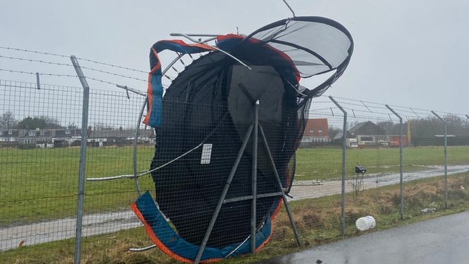
Trampoline flies across Belfast backyard during 70 mph wind gusts of Storm Eowyn
This video from Kellie Lyttle in south Belfast shows winds lifting a trampoline over a fence, from one garden into another. Lyttle told Storyful the trampoline landed in her yard Friday morning,
Another 283,000 customers in Northern Ireland were left without electricity, according to Northern Ireland Electricity, which used similar dire language about the state of the damage to their power infrastructure as their Ireland counterparts.
FindEnergy.com and Scottish Power reported another 150,000 had lost power in Scotland.

A brave meteorologist measures hurricane-force wind gusts slamming Ireland's western shores during Storm Eowyn on Jan. 24, 2025.
(Weather & Radar / FOX Weather)
About 138,000 people in Ireland have also had water loss issues with another 750,000 at risk of losing water.
"Several water treatment plants are experiencing power outages, and where possible, backup generators are being used to operate the plants," Irish Water officials said. "As a result of the interruption to power, water levels in reservoirs around the county have dropped to low levels."
They warn water challenges could persist for days.
"This was an unprecedented storm event that has had a severe impact on our water and wastewater network nationwide," Head of Water Operations at Uisce Éireann, Margaret Attridge, said in a statement. "Our crews will work around the clock where it is safe to do so to restore water service as quickly as possible, but given the extent of the damage, it may take some time before full service is restored everywhere."
Travel has been severely impacted with nearly 20% of all flights in the region canceled, affecting about 150,000 passengers, aviation analytics firm Cirium reported to the BBC. Dublin, Ireland, Edinburgh and Glasgow in Scotland and London’s Heathrow Airport were the most affected.
A trampoline sits perched against an outer fence at Scotland's Edinburgh Airport during Storm Eowyn on Jan. 24, 2025.
(Edinburgh Airport)
Train service cancelations and delays spread across Ireland, Northern Ireland and Scotland, as downed trees blocked tracks. Schools were shuttered for the day, including all classes in Edinburgh and Glasgow, according to the BBC.
Calls for help from the storm have kept police in Northern Ireland very busy.
"Police have received over 2,000 calls for service so far today, which is around 50% more than we would usually expect to see on a normal Friday," Assistant Chief Constable Davy Beck with the Police Service of Northern Ireland said. "Many roads across Northern Ireland are still currently impassable, with fallen trees, power lines and debris."

Europe on alert for powerful bomb cyclone
Weather alerts have been issued by local national weather services for Ireland and the United Kingdom as a powerful storm system works across the Northern Atlantic into western Europe. Forecasters expected peak wind gusts to reach 80-100 mph on Friday and into the early weekend.
Linda Hughes, from Met Éireann, spoke to FOX Weather about the storm system and described it as one of the strongest in recent memory.
"It’s certainly going to be a very unusual event," Hughes stated.
TORNADOES RIP ACROSS GERMANY INJURING DOZENS
A "bomb cyclone" is an area of low pressure that has seen a drop of 24 millibars of air pressure during a period of 24 hours or less. It commonly happens in hurricanes.
While the western part of the European continent is no stranger to intense storm systems, hurricane-force wind gusts were expected to down trees and cause widespread power outages.

SCOTLAND - JANUARY 24: People walk about in the heavy rain on January 24, 2025 in Helensburgh, Scotland, United Kingdom. (Photo by Jeff J Mitchell/Getty Images)
(Getty Images)
"The models have been doing pretty good this week with forecasting this storm," Hughes said. "So thankfully, we've had a few days to prepare the public for what's coming."
EUROPE IS WORLD’s FASTEST-WARMING CONTINENT, SCIENTISTS SAY
Across Western Europe, a temporary reprieve from the hazardous weather is expected late Saturday into Sunday. However, forecasters are already tracking another significant area of low pressure that is expected to impact some of the same areas late into the weekend and into next week.
"A further area of low pressure will influence the UK’s weather from Sunday, initially in the west, but spreading further east and bringing further wind and rain from Sunday and into the start of next week, with further warnings issued," the UK’s national weather service stated.
Éowyn started as historic snowstorm in southern US
The storm system, aided by a powerful jet stream, over-preformed along the U.S. Gulf Coast, with record amounts of ice and snow along the Interstate 10 corridor.
New Orleans saw its snowiest day in more than 100 years with 8 inches of frozen precipitation at the Big Easy’s international airport and nearby Mobile, Alabama, smashed its 130-year-old snow record.
Climatologists are still combing through observations in Florida, but the state easily surpassed its all-time greatest snowfall event. That was on March 6, 1954, when just 4 inches fell outside of Pensacola. During the most recent event, Pensacola officially reported 8.9 inches with totals nearing double digits in nearby communities.
Following the ice and snow, a record chill overtook the region with real-feel temperatures dropping into the single digits as far south as the Gulf Coast.
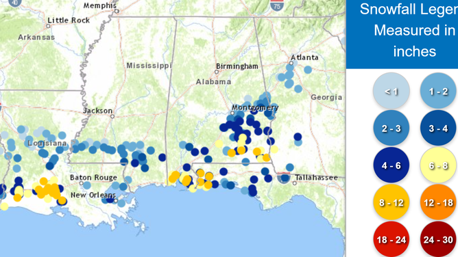
Snowfall accumulation map from 1/21/2025
(NOAA)