How Helene's tropical moisture ahead of landfall could bring significant flooding to Atlanta, Southeast
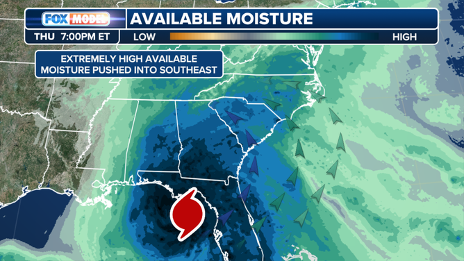
The expected torrential downpours are courtesy of a combination of factors as tropical moisture streaming ahead of Helene’s expected arrival on Thursday interacts with both a stalling front and the terrain of the Appalachian Mountains to create a recipe for persistent rains.
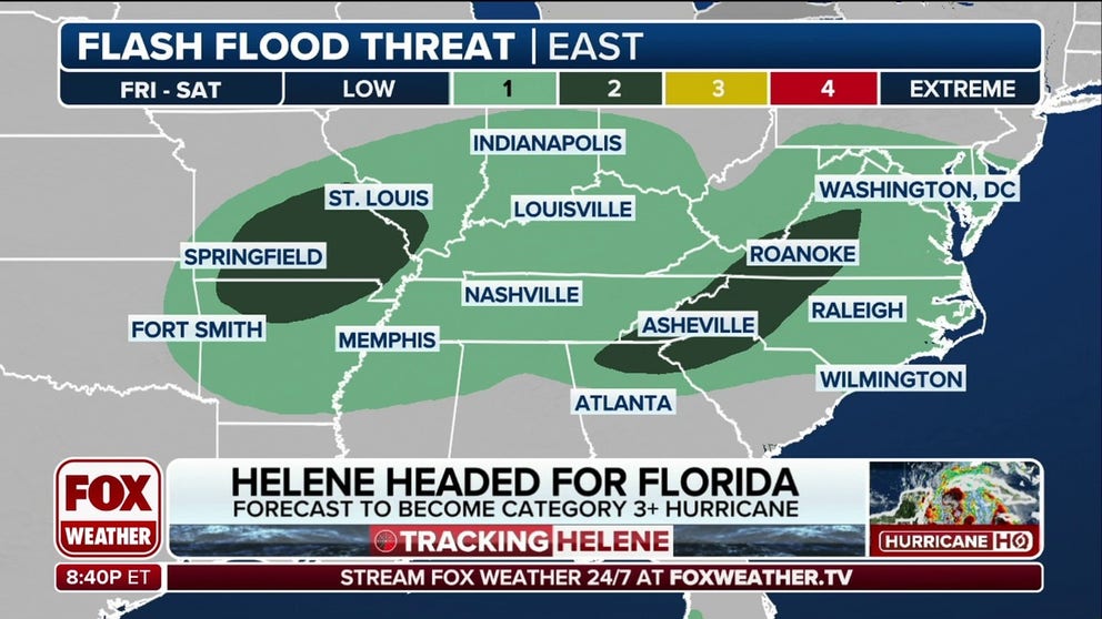
Helene to bring flash flood threat to Southeast
The impacts of Helene will be widespread, as Helene will bring moisture throughout the Southeast and create flash flooding conditions in the region. Sept. 24, 2024.
ATLANTA — A dangerous flash flooding threat looms on the eve of Hurricane Helene across a wide swath of the Southeast on Wednesday – including the Atlanta metro area – even though Helene will be hundreds of miles away.
The expected torrential downpours are courtesy of a combination of factors as tropical moisture streaming ahead of Helene’s expected arrival on Thursday interacts with both a stalling front and the terrain of the Appalachian Mountains to create a recipe for persistent rain.
Appalachian Flooding
(FOX Weather)
This pattern alone is favorable for flash flooding, but once the storms reach northern Georgia, the western Carolinas, and far eastern Tennessee, then they will have the terrain of the southern Appalachians to contend with, according to the FOX Forecast Center.

(FOX Weather)
The mountains will help provide lift for the moisture, squeezing out even more rain and triggering flash flooding potential.
"(Helene will) bring in all of that moisture, not just from the Gulf (of Mexico). Some is going to be from the western Atlantic," said FOX Weather Meteorologist Steve Bender. "We know it's that warm current, that Gulf Stream – all of that getting thrown into the mountains. That creates a major rain event."
Farther south, the line of persistent seems to remain in or near the Atlanta area, and the increased runoff from the urban area effects will also increase the flash flooding potential, especially when it comes to streets and small creeks and streams, the FOX Forecast Center said.
NOAA’s Weather Prediction Center has placed the region in a Level 3 out of 4 risk for Flash Flooding on Wednesday, as rainfall totals in this event could reach or exceed 4 inches.

(FOX Weather)
That sets the stage for the ground to be saturated with potential flooding already in place for the arrival of Helene on Thursday and its direct tropical downpours. That is when the Weather Prediction Center has placed mountains of the Carolinas and northeast Georgia under a high risk of flash flooding.
By the time Helene moves out on Friday, some areas could see in excess of 8 inches of rain in Georgia, especially the northeastern area. While areas in western North Carolina and eastern Tennessee could see up to 10 inches of rain or more by Friday.
The potential for multiple inches of rain so soon before the arrival of rain associated with a major hurricane will greatly exacerbate the impacts from flooding from Helene's rains, the FOX Forecast Center said.