Western Kentucky’s recovery efforts after historic rains challenged by renewed flood threat
Towns like Mayfield and Paducah in Kentucky will be on high alert Thursday as recovery efforts are underway following a day of life-threatening flooding. More heavy rain is in the forecast as saturated moisture levels and swollen creeks persist. Some areas could receive an additional to 2 inches of rain.

Mayfield, KY neighborhoods flood after record rain
Widespread flooding occurred Wednesday in portions of Kentucky, where more than 11 inches of rain fell in a relatively short time period. Authorities in Mayfield went door-to-door to evacuate families from their homes as communities prepared for the dire hours ahead.
MAYFIELD, Ky. – There's no rest for the weary in western Kentucky on Thursday, cleaning up just one day after historic rains and widespread flooding slammed the region.
A Flood Watch remains in place for parts of Kentucky, Tennessee, Illinois and Missouri through Thursday morning as more thunderstorms run through the waterlogged region. NOAA's Weather Prediction Center said there is a moderate risk for flash flooding in the Tennessee Valley area.

(FOX Weather)
Towns like Mayfield and Paducah in Kentucky will be on high alert because there is so much moisture in the soil, and creeks are still swollen as more heavy rain looms in the forecast. Some areas could receive an additional 1-2 inches on top of the once life-threatening flooding.
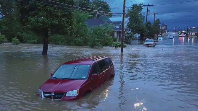
Flooding in Mayfield, Kentucky, on Wednesday, July 19, 2023, comes just 18 months after a deadly EF-4 tornado slammed the town.
(Brandon Clement / LSM)
The rain will only hamper the recovery efforts as the region tries to wring out from rainfall amounts never before observed in the state.
Kentucky's governor declared a state of emergency in response after 11.28 inches of rain fell in the past 24 hours near Mayfield in Graves County between 12 a.m. and 1 p.m. The National Weather Service said the preliminary rain report breaks the 1997 statewide record for total rainfall over 24 hours.
"Just like every challenge we face we'll get through this - we'll get through this together," Gov. Andy Beshear said. "We will be there; we will make sure we are providing resources and help our people make it through yet another challenge."
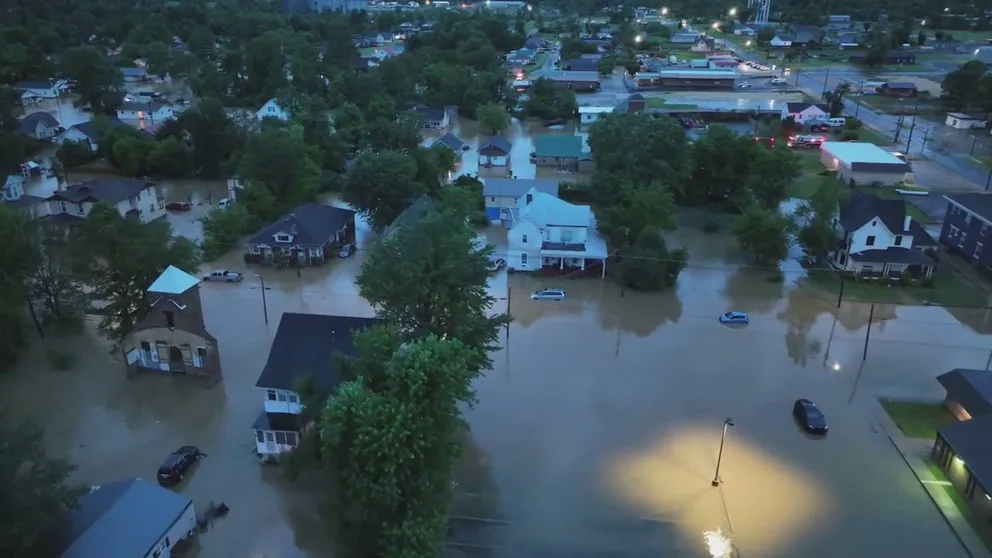
Drone video: Neighborhoods underwater following life-threatening flooding in Mayfield, Kentucky
At first light, storm chaser Brandon Clement got a view entire neighborhoods underwater where a Flash Flood Emergency was issued in Mayfield, Kentucky, with more rain on the way Wednesday.
Drone footage over Mayfield during predawn hours Wednesday showed how neighborhoods were quickly inundated with water, overwhelming backyards and homes.
The catastrophic flooding comes as Mayfield is still recovering 18 months after a deadly EF-4 tornado slammed the town. During that outbreak, more than 1,000 homes were lost and 80 people were killed
"This is a setback, of course," Mayor Kathy O'Nan told FOX Weather. "I think it's discouraging, probably for a lot of us, because we just don't need anything right now. We are moving forward, which is so wonderful, but as with everything, we will plow right through this, too."
LIFE-THREATENING FLOODING PUMMELS WESTERN KENTUCKY, SUBMERGING HOMES AND STRANDING RESIDENTS
Record rains prompt Flash Flood Emergency alerts
Drivers found themselves trapped as the floodwaters washed away roads and filled streets, and some people needed to be rescued from their homes. Luckily, no deaths have been reported.
A record 6.95 inches of rain fell in Paducah Wednesday, which was the second-highest daily rainfall on record. The all-time record is 7.49 inches set back in 1985 with the remnants of Hurricane Elena.
7 FACTS YOU SHOULD KNOW ABOUT FLASH FLOODS

Western Kentucky recovering after Flash Flood Emergency
Just one day after historic rain slammed western Kentucky and heavy rain hit Illinois and Tennessee, another round of potentially flooding storms has their sights set on the region.
Footage filmed by Jeff Kent showed floodwaters in the Oakdale neighborhood of Paducah on Wednesday morning as a Flash Flood Emergency was issued.

Severe flooding hits western Kentucky
Heavy rain triggered flash flooding in parts of western Kentucky early on Wednesday, July 19, 2023. Footage filmed by Jeff Kent shows floodwaters in the Oakdale neighborhood of Paducah.
"Yesterday we saw back building, which is a process where thunderstorms roll through," FOX Weather meteorologist Britta Merwin said. "Because there's so much deep moisture in place, they continue to develop behind one another. And so you get this training effect where these thunderstorms are kind of on the train tracks, and they go right over the same spots."
Looking at 12-hour time lapse satellite imagery issued by the Cooperative Institute for Research in the Atmosphere (CIRA) at Colorado State University shows the constant rain and storms over western Kentucky where the catastrophic and life-threatening flooding unfolded Wednesday.
A 12-hour time lapse of satellite imagery shows constant rain and storms over western Kentucky on Wednesday, July 19, 2023.
(CIRA)
On the heels of this activity, a third round of storms containing heavy rain will traverse the region on Friday.
An additional 1 to 3 inches of rain will be possible leading to yet more chances for flooding, the FOX Forecast Center said.