Flash Flood Emergencies issued in multiple states as 'generational flooding' swamps central US
The National Weather Service issued multiple Flash Flood Emergencies - their most dire flooding alerts - for towns in three states Friday night and Saturday as torrential rains led to life-threatening flooding.

Flash Flood Emergencies issued for life-threatening flooding in southeastern Missouri
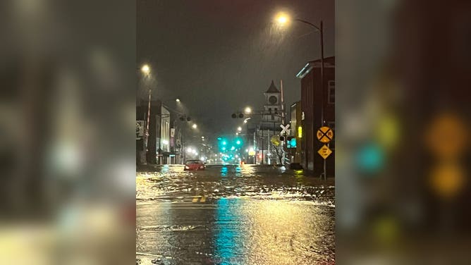
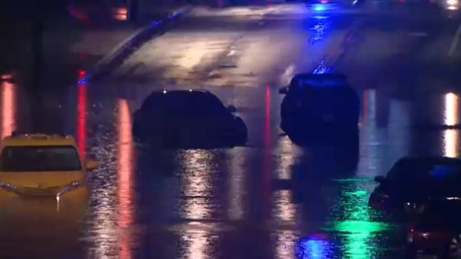
Cape Girardeau, Missouri was among several cities under life-threatening flood alerts Friday night as 2-4 inches of rain fell in a short period.
Fast Facts:
- Flash Flood Emergencies cover parts of three states amid multiple water rescues.
- A boy was killed in Kentucky after floodwater swept him away as he was heading to the bus stop.
- NWS Memphis said: "This is not your average flood risk. Generational flooding with devastating impacts is possible."
- Rounds of storms dropped more than a foot of rain across the Mississippi and Ohio valleys.
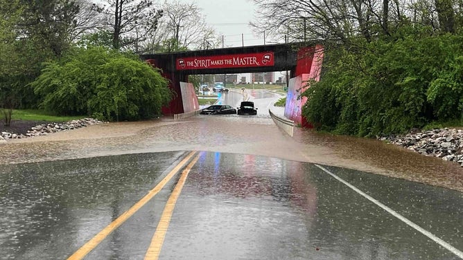
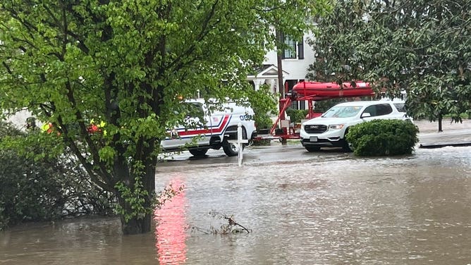
CAPE GIRARDEAU, Mo. – Life-threatening flash flooding returned to the Mississippi and Ohio valleys Friday night and Saturday morning, amid what officials warn could be part of historic flooding for the region.
The National Weather Service issued multiple Flash Flood Emergencies - their most dire flooding alerts - for towns in three states as torrential rains led to life-threatening flooding.
Little Rock, Arkansas was issued its first ever Flash Flood Emergency on Saturday as a severe thunderstorm rolled through with heavy rains and wind gusts of over 65 mph.

Severe thunderstorm pummels Little Rock area with relentless lightning, torrential rain
FOX Weather's Mike Seidel and photographer Jarrod Maloney were in the thick of a massive thunderstorm as it swept through the Little Rock, Arkansas area Saturday morning, dodging lightning strikes as the NWS issued a Flash Flood Emergency.
Farther north, near the Missouri border, the swollen Warm Fork Spring River wiped out a bridge at Mammoth Spring State Park, leading to a large train derailment across and along the river.
TRAIN DERAILS IN ARKANSAS AS SWOLLEN RIVER FLOODS BRIDGE IN STATE PARK

A trail derailed as the Warm Fork Spring River flooded during severe storms on April 5, 2025.
(Donell Russell / FOX Weather)
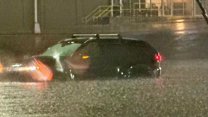
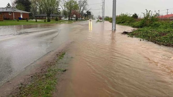
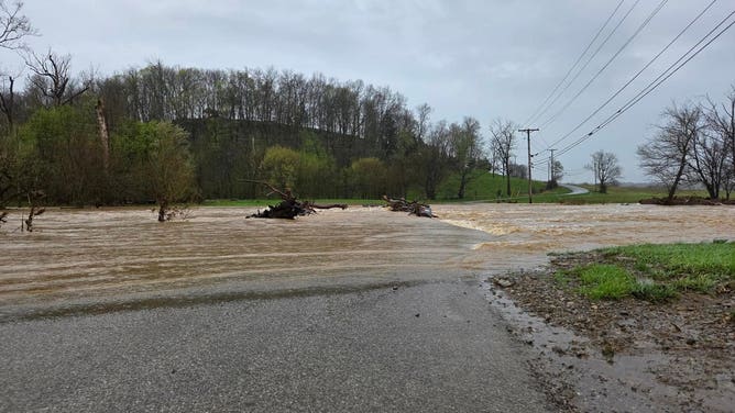
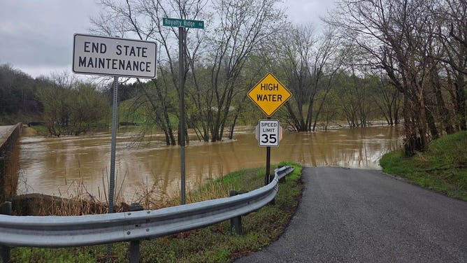
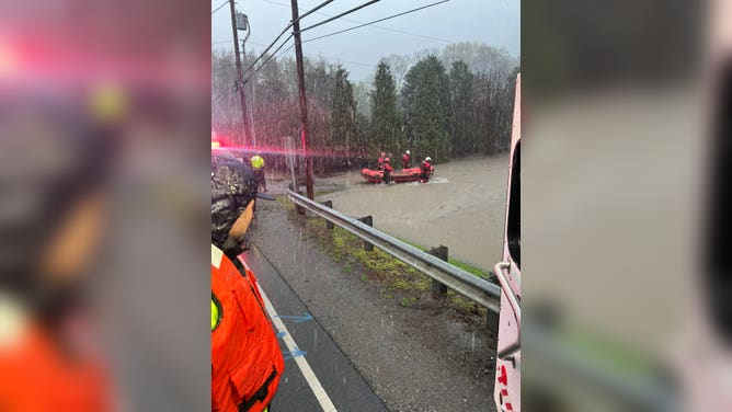
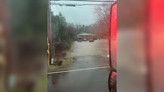
In Missouri, tens of thousands in Cape Girardeau and Van Buren were under flooding emergency Friday night. Cape Girardeau reported over 3 inches of rain in just over 90 minutes late Friday evening in one burst, with emergency managers reporting at least 10 roads covered in water and ongoing water rescues.

Flooding in West Plains, MO
(Missouri Division of Fire Safety / FOX Weather)
FLOOD WATCH, WARNING AND EMERGENCY: HERE ARE THE DIFFERENCES THAT COULD SAVE YOUR LIFE
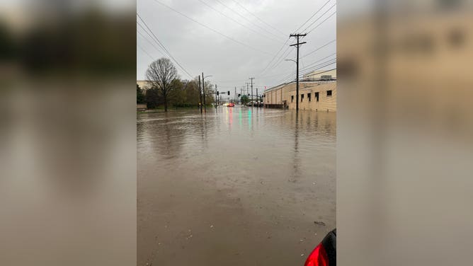
Forecasters issued similar dire warnings for the Texarkana region of northeastern Texas and southwestern Arkansas where 2-4 inches of rain fell and water rescues were ongoing Friday night as well.
"THIS IS A PARTICULARLY DANGEROUS SITUATION," NWS officials warned. "SEEK HIGHER GROUND NOW!"
Flooding in Texarkana, Texas during a Flash Flood Emergency on Friday, April 4, 2025.
(Texarkana Police Department)
Highlighting the dangerous weather around the region, there were concurrent Tornado Warnings just 20-40 miles away from the Missouri flood alerts.
Outside the Flash Flood Emeregencies, the National Weather Service offices in Little Rock, Arkansas, and Paducah, Kentucky, highlighted a widespread particularly dangerous and life-threatening flash flooding situation.
Flooding claims life of 9-year-old boy in Kentucky
A 9-year-old boy in Frankfort, Kentucky was swept away by floodwaters around 6:30 a.m. Friday while he was on his way to the school bus stop in the Hickory Hills area of the city, police said. He was found dead a few hours later.

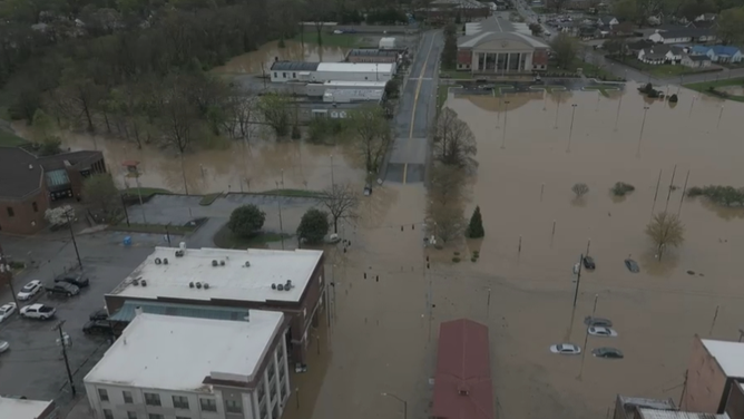
More than 8 inches of rain triggers flooding in Hopkinsville, Kentucky
Multiple homes and cars were flooded across parts of Hopkinsville, Kentucky as relentless storms dropped more than 8 inches of rain through Friday afternoon, with several more inches still in the forecast through the weekend.
Hopkinsville, Kentucky, was also flooded early Friday morning. City officials told FOX Weather that approximately 60% of the downtown was underwater, and a building had collapsed due to the heavy rain. A woman had to be rescued from floodwaters in her home and another from a car.

Aerial footage of flooding in Hopkinsville, Kentucky on April 4, 2025.
(Kirkman Aerial Photography / FOX Weather)
Drone video showed much of that flooding remained Friday afternoon. More than 8 inches of rain has fallen in some city areas since Wednesday.
WATER RESCUES REPORTED IN NASHVILLE AS 'GENERATIONAL FLOODING' SLAMS REGION

Watch: Drone video shows extensive flooding across Hopkinsville, Kentucky
Drone video shows significant flooding in Hopkinsville, Kentucky. More than 7 inches of rain had fallen in some city areas since Wednesday.
Hopkinsville officials said that at least 12 people were rescued from flooding early Friday. Mayor James Knight Jr. said this is the worst flooding the town has endured in nearly a decade.
"We haven't seen it since ‘97, ’96, somewhere right there like that," Knight Jr. said during an interview with FOX Weather. "I've lived here all my life. It is something I hope to never see again."
Floodwaters surrounded some homes and inundated cars in Van Lear, Kentucky, prompting the rescue of six people, according to local rescue officials.
![Floods in Wittensville, Kentucky]() Image 1 of 35
Image 1 of 35Floodwaters cover roads and encroach on homes in Wittensville, Kentucky on April 4, 2024. (W.R. Castle Fire-Rescue)
![Flooding in Hopkinsville, Kentucky]() Image 2 of 35
Image 2 of 35Aerial footage of flooding in Hopkinsville, Kentucky on April 4, 2025. (Kirkman Aerial Photography)
![Flooding in Hopkinsville, Kentucky]() Image 3 of 35
Image 3 of 35Aerial footage of flooding in Hopkinsville, Kentucky on April 4, 2025. (Kirkman Aerial Photography)
![Flooding in Hopkinsville, Kentucky]() Image 4 of 35
Image 4 of 35Aerial footage of flooding in Hopkinsville, Kentucky on April 4, 2025. (Kirkman Aerial Photography)
![Flooding in Hopkinsville, Kentucky]() Image 5 of 35
Image 5 of 35Aerial footage of flooding in Hopkinsville, Kentucky on April 4, 2025. (Kirkman Aerial Photography)
![Flooding in Hopkinsville, Kentucky]() Image 6 of 35
Image 6 of 35Aerial footage of flooding in Hopkinsville, Kentucky on April 4, 2025. (Kirkman Aerial Photography)
![Flooding in Hopkinsville, Kentucky]() Image 7 of 35
Image 7 of 35Aerial footage of flooding in Hopkinsville, Kentucky on April 4, 2025. (Kirkman Aerial Photography)
![Floods in Wittensville, Kentucky]() Image 8 of 35
Image 8 of 35Floodwaters cover roads and encroach on homes in Wittensville, Kentucky on April 4, 2024. (W.R. Castle Fire-Rescue)
![Flooding in Hopkinsville, Kentucky]() Image 9 of 35
Image 9 of 35Aerial footage of flooding in Hopkinsville, Kentucky on April 4, 2025. (Kirkman Aerial Photography)
![Flooding and road closures in Bowling Green, Kentucky April 3.]() Image 10 of 35
Image 10 of 35Flooding and road closures in Bowling Green, Kentucky April 3. (City of Bowling Green/Facebook)
![Flooding and road closures in Bowling Green, Kentucky April 3.]() Image 11 of 35
Image 11 of 35Flooding and road closures in Bowling Green, Kentucky April 3. (City of Bowling Green/Facebook)
![Drone images show downtown Hopkinsville inundated. Officials told FOX Weather at least 60% of the downtown was flooded Friday morning.]() Image 12 of 35
Image 12 of 35Drone images show downtown Hopkinsville inundated. Officials told FOX Weather at least 60% of the downtown was flooded Friday morning. (Ezell Productions by Hunter Ezell)
![]() Image 13 of 35
Image 13 of 35Hopkinsville, Kentucky was inundated Friday morning. Officials told FOX Weather at least two people have been rescued and more than half of downtown was flooded. (Brittanie Bogard)
![Flooding and road closures in Bowling Green, Kentucky April 3.]() Image 14 of 35
Image 14 of 35Flooding and road closures in Bowling Green, Kentucky April 3. (City of Bowling Green/Facebook)
![]() Image 15 of 35
Image 15 of 35Hopkinsville, Kentucky was inundated Friday morning. Officials told FOX Weather at least two people have been rescued and more than half of downtown was flooded. (Brittanie Bogard)
![]() Image 16 of 35
Image 16 of 35Hopkinsville, Kentucky was inundated Friday morning. Officials told FOX Weather at least two people have been rescued and more than half of downtown was flooded. (Brittanie Bogard)
![]() Image 17 of 35
Image 17 of 35Hopkinsville, Kentucky was inundated Friday morning. Officials told FOX Weather at least two people have been rescued and more than half of downtown was flooded. (Brittanie Bogard)
![A road disappears under floodwater in Washington County in central Kentucky.]() Image 18 of 35
Image 18 of 35A road disappears under floodwater in Washington County in central Kentucky. (Washington County Sheriff's Office)
![Flooding in Washington County in central Kentucky.]() Image 19 of 35
Image 19 of 35Flooding in Washington County in central Kentucky. (Washington County Sheriff's Office)
![Flood rescue in Nashville on Thursday.]() Image 20 of 35
Image 20 of 35Flood rescue in Nashville on Thursday. (Nashville Fire Department)
![Flood rescue in Nashville on Thursday.]() Image 21 of 35
Image 21 of 35Flood rescue in Nashville on Thursday. (Nashville Fire Department)
![Flood rescue in Nashville on Thursday.]() Image 22 of 35
Image 22 of 35Flood rescue in Nashville on Thursday. (Nashville Fire Department)
![Flood rescue in Nashville on Thursday.]() Image 23 of 35
Image 23 of 35Flood rescue in Nashville on Thursday. (Nashville Fire Department)
![]() Image 24 of 35
Image 24 of 35The Nashville Fire Department performed water rescues Thursday morning April 3. (Nashville Fire Department)
![]() Image 25 of 35
Image 25 of 35The Nashville Fire Department performed water rescues Thursday morning April 3. (Nashville Fire Department)
![A road disappears under floodwater in Washington County in central Kentucky.]() Image 26 of 35
Image 26 of 35A road disappears under floodwater in Washington County in central Kentucky. (Washington County Sheriff's Office)
![]() Image 27 of 35
Image 27 of 35The Nashville Fire Department performed water rescues Thursday morning April 3. (Nashville Fire Department)
![Daylight revealed flooded out neighborhoods in Nashville, TN April 3.]() Image 28 of 35
Image 28 of 35Daylight revealed flooded out neighborhoods in Nashville, TN April 3. (WREG)
![Daylight revealed flooded out neighborhoods in Nashville, TN April 3.]() Image 29 of 35
Image 29 of 35Daylight revealed flooded out neighborhoods in Nashville, TN April 3. (WREG)
![]() Image 30 of 35
Image 30 of 35Video shows several vehicles stuck in floodwaters on Murfreesboro Pike and Lafayette Street in South Nashville. (WZTV)
![Video shows several vehicles stick in flood waters on Murfreesboro Pike and Lafayette Street in South Nashville.]() Image 31 of 35
Image 31 of 35Video shows several vehicles stuck in floodwaters on Murfreesboro Pike and Lafayette Street in South Nashville. (WZTV)
![Floods in Wittensville, Kentucky]() Image 32 of 35
Image 32 of 35Floodwaters cover roads and encroach on homes in Wittensville, Kentucky on April 4, 2024. (W.R. Castle Fire-Rescue)
![Flooding in Hopkinsville, Kentucky]() Image 33 of 35
Image 33 of 35Aerial footage of flooding in Hopkinsville, Kentucky on April 4, 2025. (Kirkman Aerial Photography)
![Floods in Wittensville, Kentucky]() Image 34 of 35
Image 34 of 35Floodwaters cover roads and encroach on homes in Wittensville, Kentucky on April 4, 2024. (W.R. Castle Fire-Rescue)
![Floods in Wittensville, Kentucky]() Image 35 of 35
Image 35 of 35Floodwaters cover roads and encroach on homes in Wittensville, Kentucky on April 4, 2024. (W.R. Castle Fire-Rescue)


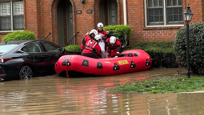
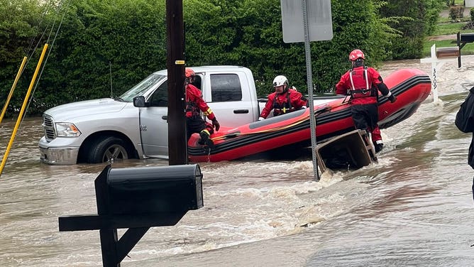


Flooding creates massive headaches in Nashville, Memphis
More than 7 inches of rain fell earlier this week in western Tennessee, triggering flooding in Nashville. The Nashville Fire Department performed more than a dozen water rescues on Thursday as cars became stuck in floodwaters.
By Thursday afternoon, creeks and rivers had already overflowed their banks in Memphis.
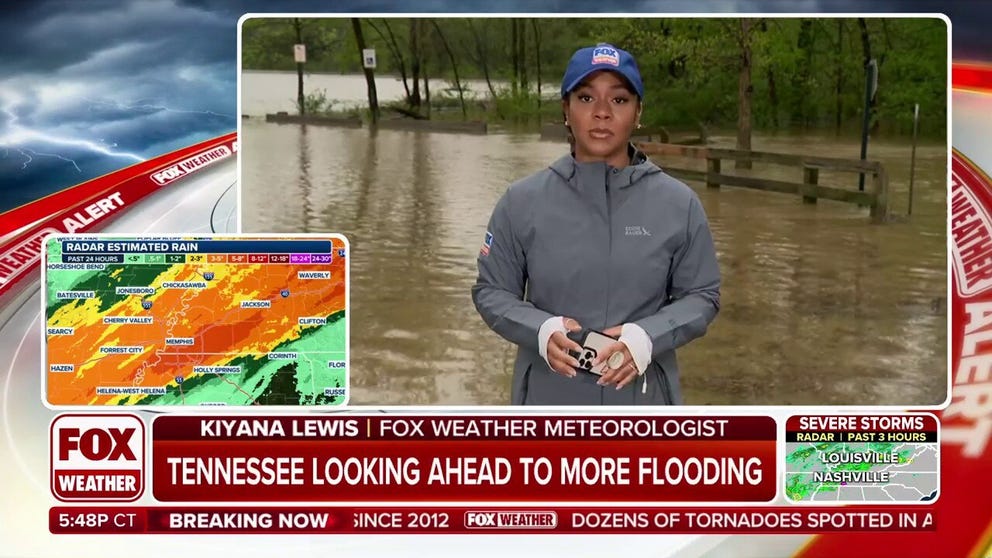
West, Middle Tennessee slammed by flash flooding
Torrential rains have caused rivers and creeks to overflow in parts of West and Middle Tennessee, as those areas will receive even more rain in the days to come. FOX Weather Meteorologist Kiyana Lewis reports from Memphis, Tennessee.
Nashville and Memphis both recorded daily rain records on Thursday. Nashville more than doubled its daily rain record with 3.8 inches of rain, shattering the old record of 1.5 inches from 1977. This was Music City's second-wettest April day on record.
LIVE STORM TRACKER: SEVERE WEATHER MAPS, FLOODING FORECASTS, RADARS AND MORE
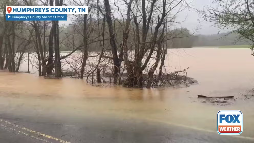
Flooding hits central Tennessee as weather officials warn of severe thunderstorms
Flash flooding affected parts of central Tennessee on Thursday as the National Weather Service said that severe thunderstorms were moving across the region. This footage of a partially flooded road was captured by the Humphreys County Sheriff’s Office, who urged residents to avoid flooded roadways.
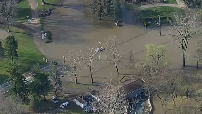
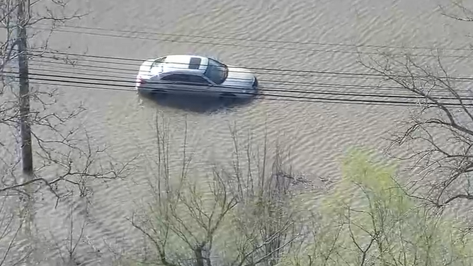
Flooding was also impacting Indiana, where officials in the City of Shelbyville and Shelby County were encouraging residents in low-lying areas to head to higher ground.
The nearby Big Blue River in Shelbyville was expected to reach at least major flood status over the weekend and peak just shy of the record of 20.2'.
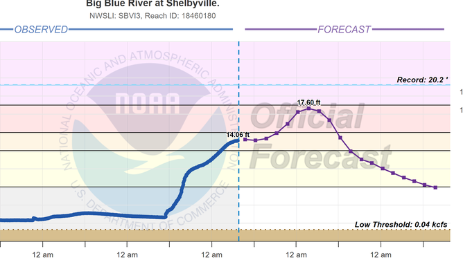
Big Blue River status in Indiana.
(NOAA)
Life-threatening flash flooding threat extends through weekend
The dire flooding threat stretches through the weekend. Repeating rounds of rainfall will lead to potentially historic amounts, particularly focused on the lower Ohio Valley, mid-South and Ozarks, according to the FOX Forecast Center.

(FOX Weather)
Storm total rain amounts of 5-15 inches are likely and some locations may see up to 20 inches. Rainfall rates of 2 inches per hour or more will lead to rapid onset flash flooding, leaving people caught off guard by the speed of water rises.
A level 4 out of 4 risk for flash flooding remains in effect Saturday for more than 5 million people. In addition, Flood Watches remain in effect for nearly a 1,000-mile stretch that includes parts of 12 states. The amount of rain will also trigger flooding in areas that do not usually flood, according to NWS forecasters.
WHY HIGH-RISK FLOOD DAYS ARE SO SERIOUS
"Total rainfall amounts through Sunday could exceed 10 to 15-inch range along and north of I-40," the NWS in Memphis said. "This is not your average flood risk. Generational flooding with devastating impacts is possible."

(FOX Weather)
Nashville forecasters agreed.
"Saturday is the day that concerns me the most right now," said Meteorologist Ryan Husted with the National Weather Service in Nashville. "Because we have time for our atmosphere to recharge, which means we have the potential for dangerous severe thunderstorms once again. In addition, our ground is saturated -- that means any rain that falls will run off and it’s going to cause flooding. I’m very confident that Saturday is a dangerous day for flash flooding going into Saturday night."

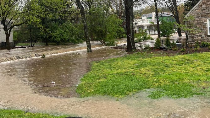
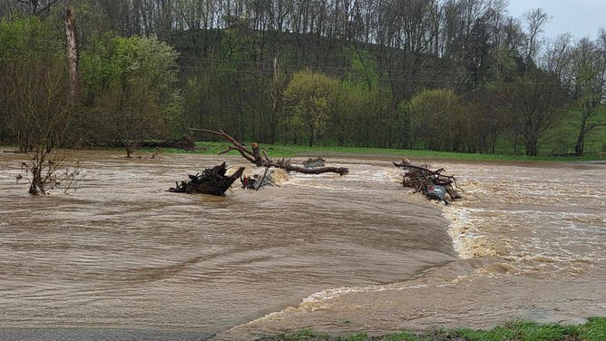
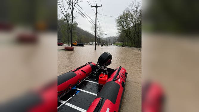
Missouri flash flooding
Creeks turned into rapids around Springfield, Missouri following heavy rainfall.
Even long after the rain ends on Sunday, the flood impacts will be far from over. All the water will continue to surge into progressively larger streams and rivers across the region.