Deadly historic winter storm blasts 245M: Snow slams Northeast as ice cripples the South
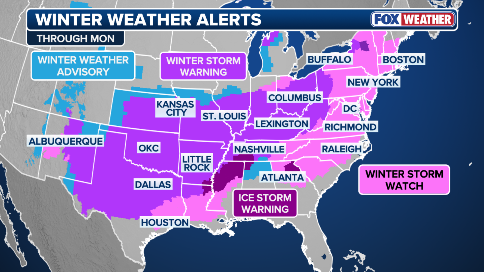
At least three confirmed storm-related deaths while more than 190 million Americans are under Winter Weather Alerts as heavy snow continues to fall from New Mexico to New York.

Historic winter storm blasts 245M: Snow slams Northeast, as ice cripples South with power outages
A historic 2,000-mile-wide winter storm is expected to peak Sunday, unleashing heavy snow, crippling ice and days of life-threatening travel conditions for more than 245 million people from New Mexico to Maine through Monday morning.
A deadly, historic 2,000-mile-wide winter storm peaked Sunday, unleashing heavy snow, crippling ice and days of life-threatening travel conditions for more than 245 million people from New Mexico to Maine through Monday morning.
LIVE UPDATES: MILLIONS UNDER ALERT AS HISTORIC WINTER STORM CHARGES ACROSS AMERICA
At least three have been confirmed dead by state officials, linking their deaths to the extreme cold from the storm.
As of Sunday, more than 190 million Americans are under Winter Weather Alerts as snow was falling from New Mexico to New York.
Ultimately, the storm carved a 2,300-mile path across more than 40 states from the Southwest into New England, delivering a volatile blend of harsh winter weather impacts.
WHAT IS A WINTER STORM WARNING?
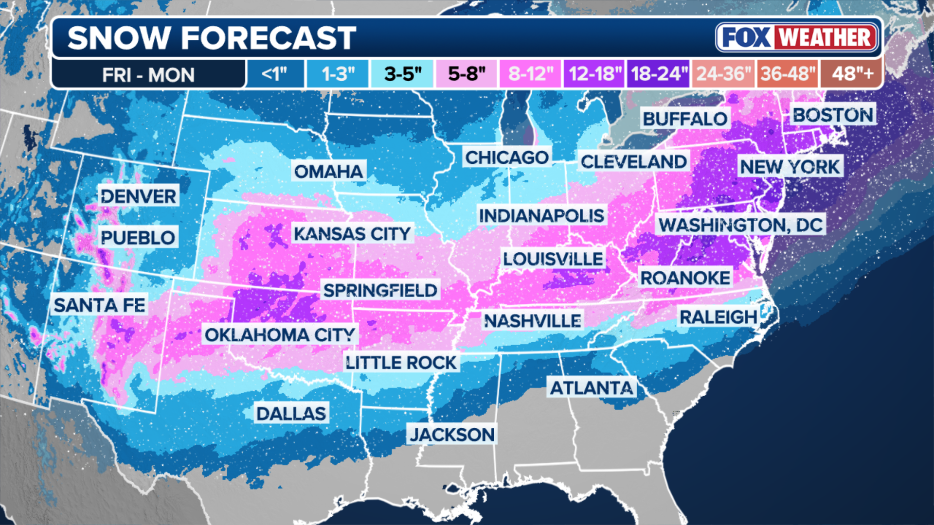
More than a dozen states have reported at least a foot of snow by Sunday afternoon.
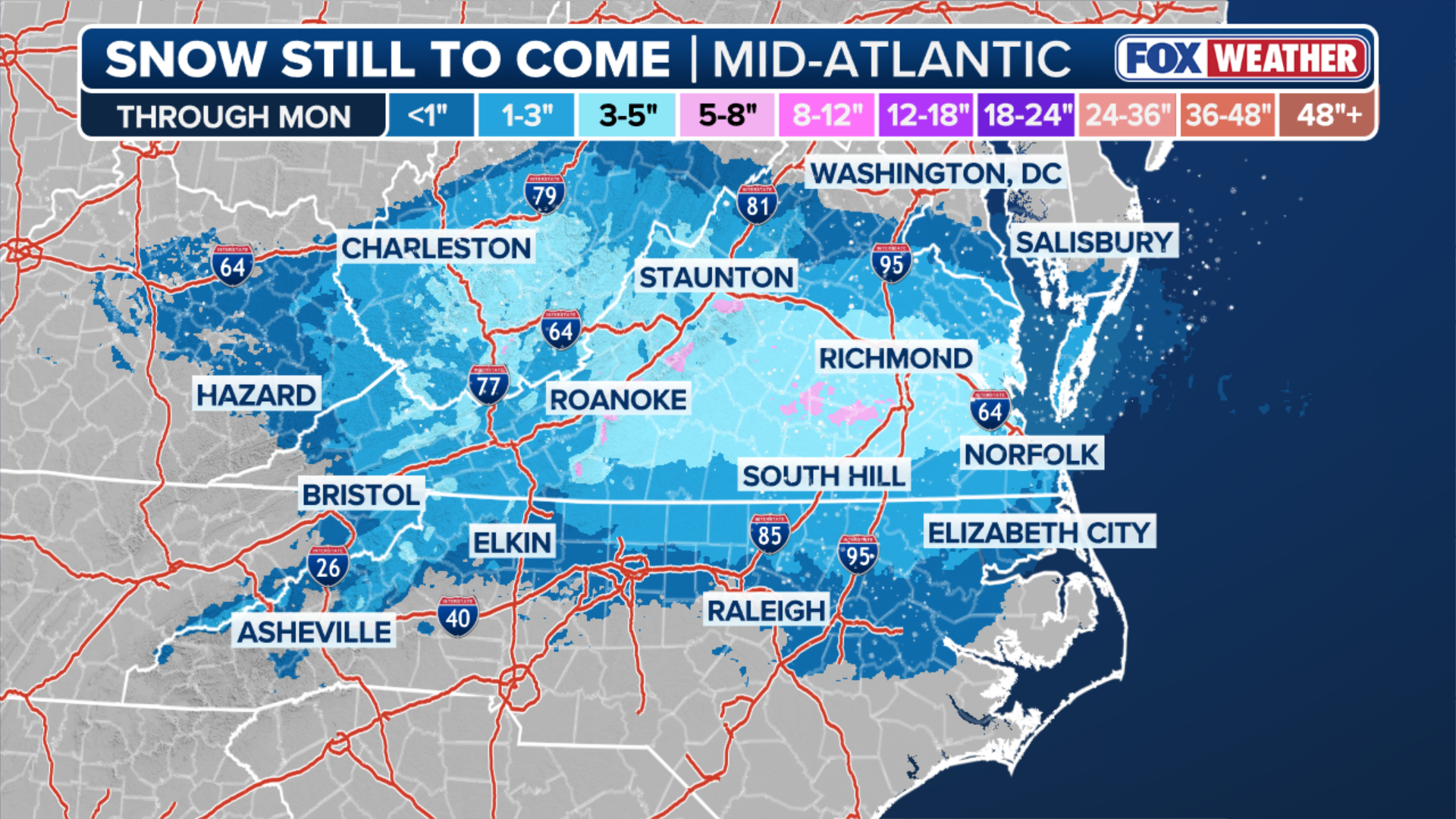
Snow has piled up from the Plains through the Midwest, Ohio Valley and Mid-Atlantic, and is forecast to culminate with a potent final blow across the Northeast and New England. New York City could see a foot of snow, while Boston may tally close to two feet of snow through Monday.
So far, both cities have received over 10 inches of snow, according to the FOX Forecast Center.
(FOX Weather)
Air travel has ground to a halt over much of the country, with over 32,000 flights canceled through Monday.
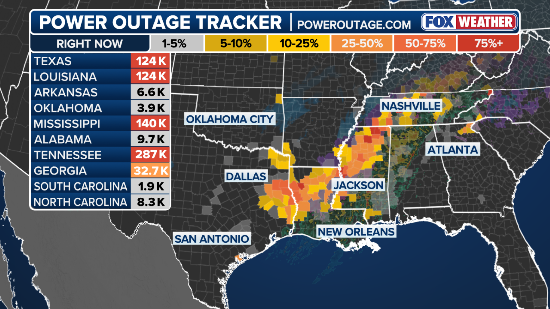
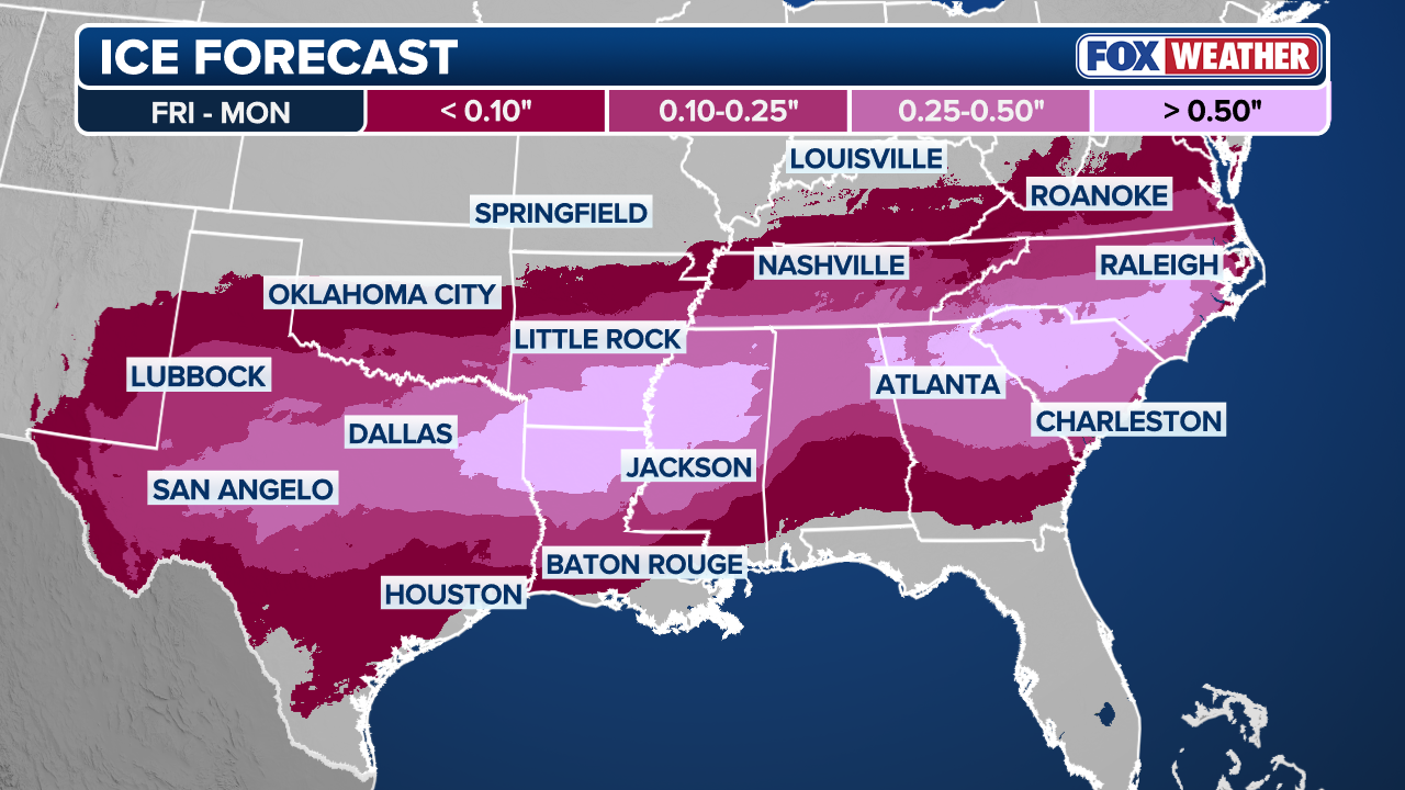
Meanwhile, a dangerous situation is unfolding across the South, where significant ice accumulations knocked out power of just shy of a million customers by Sunday night, as freezing rain intensified in the Atlanta and Nashville metro areas.
(FOX Weather)
The massive system also spawned another threat for the Gulf Coast Sunday in the form of thunderstorms capable of producing tornadoes.
Life-threatening conditions will persist even after the sprawling system clears, as a dome of arctic air associated with the polar vortex will bring days of bone-chilling temperatures to much of the country, potentially hampering power restoration efforts.
(FOX Weather)
States of emergency have already been declared in 21 states, including Arkansas, Louisiana, Mississippi, Alabama, Tennessee, Georgia, South Carolina, North Carolina, Missouri, Kansas, Kentucky, West Virginia, Ohio, Virginia, Maryland, Delaware, Pennsylvania, New York, New Jersey, Indiana, Connecticut and Washington, D.C.
FEMA had approved more than 12 of those emergency declarations by Sunday and President Donald Trump said on social media ahead of the storm that his administration is coordinating with both state and local officials.
(FOX Weather)
Heavy snow blanked the Plains beginning Saturday, particularly between Interstates 70 and 40 as well as Kentucky and into the Ohio Valley.
Three cities set new daily records for snow totals, including Paducah, Kentucky, with 4.6 inches, Oklahoma City, Oklahoma, with 4.4 inches, and Kansas City, Kansas, with 5.2 inches, according to the FOX Forecast Center.
Ice storm causing widespread power outages across the Southern Tier
A crippling ice storm is unfolding across the South with parts of Mississippi receiving about 1 inch of ice accumulation. Power outages are concentrated in Texas, Louisiana and Mississippi, but outages are increasing across the region, as the weight of the ice compromises lines and topples trees.
WHAT IS AN ICE STORM AND WHY ARE THEY SO DANGEROUS?

NASHVILLE, TENNESSEE - JANUARY 24: Snow begins to collect on Nolensville Pike on January 24, 2026, in Nashville, Tennessee. A massive winter storm is expected to bring frigid temperatures, ice, and snow to millions of Americans across the nation.
((Photo by Brett Carlsen/Getty Images) / Getty Images)
One utility in Mississippi suspended operations overnight Sunday due to unsafe working conditions as the storm intensified.
Nashville reported 0.47 inches of ice as freezing rain hammered Tennessee early Sunday.
Conditions are also deteriorating rapidly across north Georgia due to freezing rain.
HOW TO WATCH FOX WEATHER ON ANY DEVICE FOR FREE
A report from Holly Springs Sunday shows nearly a quarter of an inch of ice.
Ice Storm Warnings also cover the southern Appalachians, including parts of Tennesee, North Carolina, South Carolina and Georgia.
(FOX Weather)
Biggest snowstorm in a decade for the Northeast
It has been a decade since a foot or more of snow fell in cities like Washington, D.C., Baltimore and Philadelphia, and five years since New York City saw more than a foot. Those streaks will be put in jeopardy by this historic storm.
WHAT DOES A WINTER STORM WARNING MEAN FOR ME?
The snow was forecast to strengthen through the day Sunday, with peak snow rates potentially reaching 2 inches per hour.
(FOX Weather)
The heaviest accumulations are north and west of D.C. along I-81 through Pennsylvania, across I-80 into the tri-State area including New York City, northward into the Hudson Valley, spreading east across southern New England into Boston, where 18 to 24 inches of snow is possible.
Pittsburg, Pennsylvania, reported that Sunday was the snowiest day in 16 years, while Baltimore saw their snowiest day in a decade with 11.1 inches.
Heavy snow has already begun from the north shore of Massachusetts and extends down into the northern Cape. A widespread 12 to 18 inches of snow is likely with locally higher amounts possibly closer to two feet.
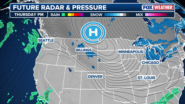
Frigid temperatures lock in winter weather impact
While current forecasts suggest that the storm will wind down Monday from west to east as the area of low pressure pulls away from the coast, the cold weather will stick around for millions of Americans, prolonging impacts for areas affected by ice and snow.
HOW HIGH PRESSURE AND LOW PRESSURE DRIVE THE WEATHER
(FOX Weather)
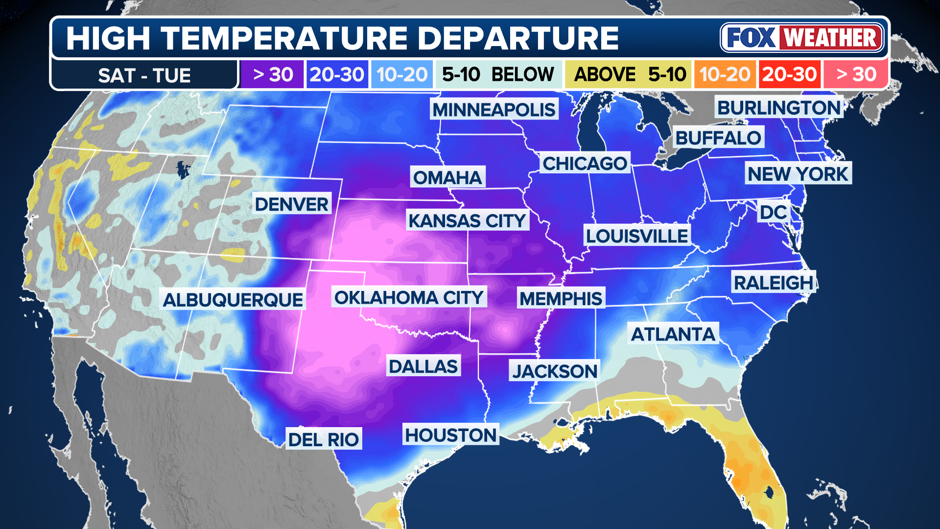
A powerful arctic high is driving exceptionally dense, bitterly cold air deep into the Lower 48. This arctic air mass will then dominate the entire weather pattern through the weekend and will play a key role in the development of the historic winter storm across the South and the East Coast.
Extreme Cold Warnings and watches now extend across much of the Upper Midwest, Plains and into the Northeast.
Major cities included in these alerts range from Minneapolis and Detroit to Boston and New York City. Farther south, locations such as Oklahoma City, Dallas and Little Rock are also under Cold Weather Alerts through the weekend.
Along the East Coast, temperatures will struggle to rise above freezing through the weekend.
The storm had already made history before any flakes flew on Friday, breaking the record for the highest number of counties simultaneously under a Winter Storm Warning.