'Historically strong' El Nino winter possible with good chance of it lasting through spring, NOAA says
The 2023 El Nino event has a chance to become historically strong. Let's take a look at what that means and what happened during the other historically strong years.
What will a strong El Nino mean for your weather?
FOX Weather brings in Colorado State research scientist Marybeth Arcodia to explain what a historically strong El Nino means and takes a look back at previous historically strong years.
NOAA's Climate Prediction Center already announced that the world is in for a "strong" El Niño winter, and on Thursday, the CPC announced a 30% chance of experiencing a "historically strong" event.
"The team favors at least a strong event with a 75-85% chance through November-January. There is a 3 in 10 chance of a historically strong event that rivals 2015-16 and 1997-98," wrote the CPC in its discussion. "Stronger El Niño events increase the likelihood of El Niño-related climate anomalies."
Forecasters give a 75% to 85% chance that El Niño will be "strong" from November to January. That means average sea surface temperatures in the central Pacific will be at or above 1.5 degrees Celsius for three months. The 30% chance of a "historically strong" El Niño means that sea surface temperatures will be at least 2 degrees Celsius warmer over the season.
"When we have a stronger El Niño event, those storms and circulation patterns are typically stronger, meaning that this can have a larger influence on the jet stream and a larger influence on weather in the United States," Marybeth Arcodia, research scientists at Colorado State University told FOX Weather.
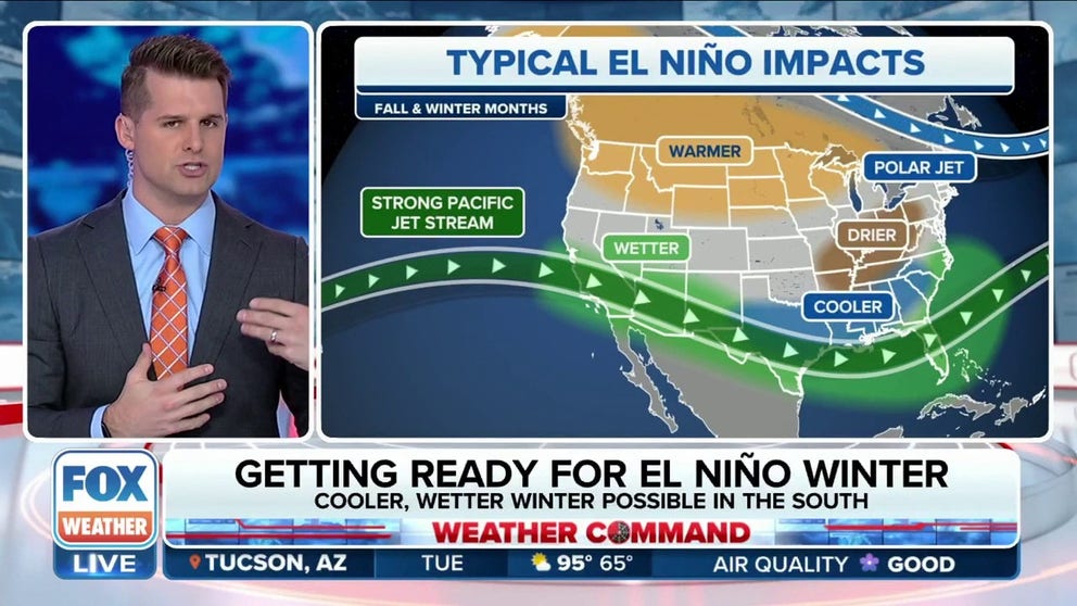
The image below shows the temperature anomalies in the central Pacific. South, Central and North America are on the right of the graphic.
HERE'S WHAT AN EL NINO CLIMATE PATTERN IS
September 2023 sea surface temperature difference from the 1985-1993 average (details from Coral Reef Watch). Much of the global oceans are warmer than average.
(Climate.gov / NOAA)
"We’ve only seen four of these (historically strong events) in our historical record, dating back to 1950," wrote Emily Becker, associate director of the University of Miami Cooperative Institute for Marine and Atmospheric Studies. "November–January (typically the peak season). We actually have a slightly higher chance, 83%, that we will reach that threshold in September-November, which is on our doorstep."
The same team also gives a very good chance of El Niño lasting from March to May, at 80%.
"The stronger the El Niño, the more likely it will affect global temperature and rain/snow patterns in expected ways," continued Becker.
STRONG EL NINO WINTER: WHAT KIND OF WEATHER YOU CAN EXPECT
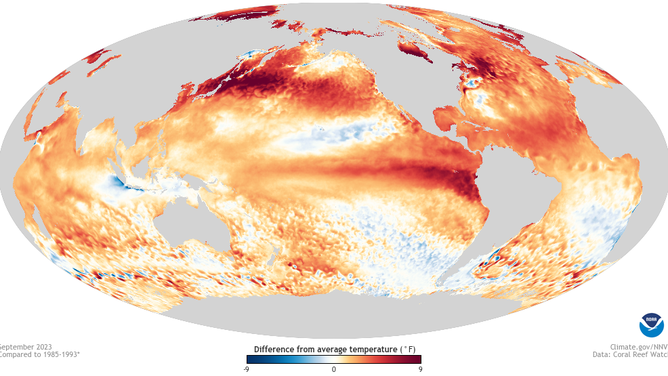
Typical El Nino impacts become more likely with a strong or historic event.
(FOX Weather)
"The reason that's important is those sea surface temperatures control where normally large thunderstorms are, what we would call deep convection is," the Director of the Climate Prediction Center, Dave DeWitt, told FOX Weather. "And that deep convection actually has a large influence on the jet stream. And when you have an El Nino event, the jet stream tends to shift south and east of its normal pattern. And that's how it has major impacts over the U.S."
Looking back at "historic El Nino" events
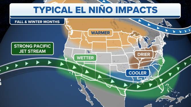
Deadly 1997-98 El Niño
Over the winter of 1997-98, the West Coast suffered destructive storm after storm. California alone lost 17 people, and 27 homes were red-tagged, according to the California Coastal Commission. Los Angeles received a record 13.86 inches of rain in February, according to the NWS.
The Los Angeles Times reported that damages totaled over half a billion dollars.
File: A luxury home in the Orange County suburb of Laguna Niguel slips down a hillside March 19, 1998 eroded by heavy El Nino generated rains earlier in the month. Two homes and seven condominiums have been destroyed in the slide and several more are threatened with destruction.
( VINCE BUCCI/AFP / Getty Images)
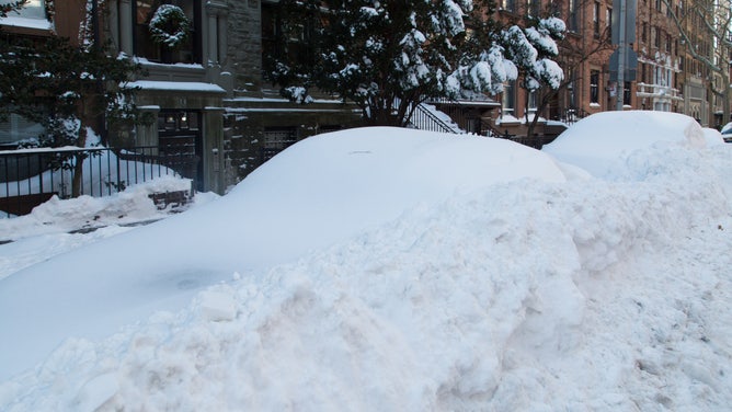
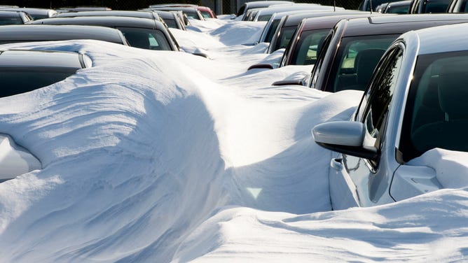
Crippling 2015-16 El Nino
"January 2016, El Nino, New York City saw the biggest blizzard it's ever had," recalled Meteorologist Amy Freeze.
The city recorded the second-biggest snowstorm in history. A large area of 2 feet of snow fell across the eastern seaboard, crippling the I-95 corridor.
![]() Image 1 of 2
Image 1 of 2FILE: NEW YORK - 2016/01/24: Winter storm Jonas burries New York recorded as the second biggest Snow storm in New York City history. The mounds are snow covered cars. ( Louise Wateridge/Pacific Press/LightRocket)
![]() Image 2 of 2
Image 2 of 2FILE: Rental cars are buried in snow, at Dulles International Airport(IAD) January 25, 2016, outside Washington, DC, in Sterling,Virginia. - The icy streets of the US capital remained largely deserted Monday on the first work day after a mammoth blizzard smothered the East Coast, with schools and the federal government closed as people dug their cars and doorways out from mountains of snow. (PAUL J. RICHARDS/AFP)
Again, the West Coast saw unimaginable erosion.
"The 2015/16 El Niño was one of the strongest of the last 145 years, with winter wave energy equal to or exceeding measured historic maxima all along the Western U.S. coast and anomalously large beach erosion across the region," wrote the commission.
How does 2023 El Niño compare to 2015
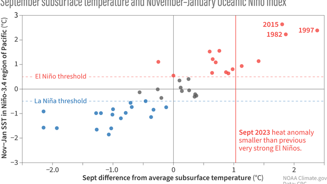
Each dot on this scatterplot shows the subsurface temperature anomaly (difference from the long-term average) in the central tropical Pacific each September (horizontal axis) since 1979 versus the oceanic ENSO conditions the following November–January (vertical axis). The vertical red line show the September 2023 subsurface temperature anomaly. The amount of warmer-than-average water under the surface in September has a strong relationship with the oceanic ENSO conditions later in the year. Previous very strong El Niño events, 1982–83,1997–98, and 2015–16, had more subsurface warm water than 2023.
(Climate.gov / NOAA)
Currently, sea surface temperatures are behind the three historic strong events. The red line shows the above-normal sub-surface temperatures compared to other El Niño years. So far, 2023 is falling behind the heat of 2015, 1982 and 1997, but don't rule "historic strength" out.
"While there is still a good amount of heat under the surface of the Pacific—this warmer water provides a source to the surface—it’s not quite at the level we’ve seen during previous historically strong El Niños like 1982–83, 1997–98, or 2015–16," said Becker.
But, she says, the world has seen record global ocean warmth this year.