CSU experts increase hurricane forecast for Atlantic season: Beryl likely 'harbinger of a hyperactive season'
Their already aggressive forecast for the number of hurricanes and tropical storms this season has increased even further, extending a record number of predicted storms.
New updated hurricane forecast by CSU experts is even more aggressive in calling for 'hyperactive' year
Experts at Colorado State University have upped their forecast for number of hurricanes and major hurricanes in the Atlantic basin just a day after record-breaking Hurricane Beryl made landfall in Texas.
FORT COLLINS, Colo. — Hurricane Beryl and its record-setting early season journey that culminated in three devastating landfalls and a trail of deadly destruction is likely just the start of a budding "hyperactive" hurricane season, according to the updated hurricane season forecast from experts at Colorado State University released Tuesday.
Their already aggressive forecast for the number of hurricanes and tropical storms this season has increased even further, extending a record number of predicted storms.
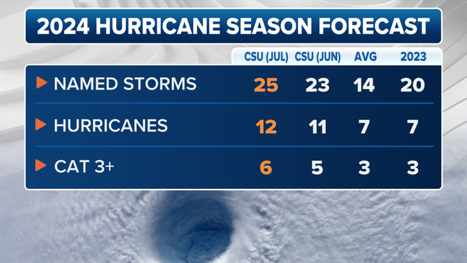
Dr. Phil Klotzbach, a senior research scientist at CSU, and his team are now calling for 25 named storms, of which 12 would reach hurricane strength and six that would become major hurricanes.

2024 updated Colorado State University hurricane season forecast.
(FOX Weather)
That’s an increase from their previous updated forecast from early June that called for 23 named storms, of which 11 would become hurricane-strength and five would become major hurricanes.
HISTORIC HURRICANE BERYL REWRITES THE RECORD BOOKS
The season has already had three named storms, including the aforementioned Beryl which not only reached major hurricane status but set a record for the earliest Category 5 storm on record. Those three storms are included in the forecast count.

(FOX Weather)
The tropics have since quieted down since Hurricane Beryl came ashore, with no tropical activity expected in the next seven days thanks to a widespread Saharan dust layer in the Atlantic. But the Atlantic basin is still primed and ready for a busy season once the dust layers abate later in the season.
"Sea surface temperatures averaged across the hurricane Main Development Region of the tropical Atlantic and Caribbean remain near record warm levels," the CSU team wrote, adding those warm waters are an ample source of fuel for tropical development.
In addition, El Niño is gone, and the ensuing neutral or budding La Niña pattern that is likely to be in place for the peak of the hurricane season later this summer will reduce wind shear that would also typically inhibit tropical storm development.
EL NIÑO CLIMATE PATTERN OFFICIALLY ENDS AS FLIP TO HURRICANE-FUELING LA NIÑA LOOMS
"Hurricane Beryl, a deep tropical Category 5 hurricane, is also a likely harbinger of a hyperactive season," CSU forecasters wrote. "This forecast is of above-normal confidence. We anticipate a well above-average probability for major hurricane landfalls along the continental United States coastline and in the Caribbean."
CSU forecasters now give a 57% probability that a major hurricane (Category 3 or higher) will strike the U.S. coastline this season. An average season has a 43% chance. More specifically, they give a 31% probability that a major hurricane will strike the Atlantic Coast or Florida Peninsula and a 38% chance of a major hurricane making landfall along the Gulf Coast (including the Florida Panhandle).
The CSU forecast remains in line with NOAA and 14 other forecasting agencies and computer models in predicting an above-average hurricane season – and in some cases, a well-above-average season.
If the 25 named storms come to fruition, the National Hurricane Center would exhaust its main list of 22 hurricane names for 2024 and resort to a secondary list of names. An average season has 14 named storms, with seven becoming hurricanes.
HERE'S WHAT HAPPENS IF WE RUN OUT OF HURRICANE NAMES THIS YEAR
"As with all hurricane seasons, coastal residents are reminded that it only takes one hurricane making landfall to make it an active season," CSU forecasters said. "Thorough preparations should be made every season, regardless of predicted activity."
