Hurricane Francine triggers Flash Flood Emergency for New Orleans as torrential rainfall causes water rescues
A Flash Flood Emergency is the highest-level alert that can be issued by the National Weather service during a flooding event. The flooding alert was issued as the New Orleans metro entered the eyewall of Hurricane Francine.

Hurricane Francine triggers Flash Flood Emergency for New Orleans
Life-threatening flooding was likely in New Orleans and communities west along Interstate 10 Wednesday night as the core of Hurricane Francine moved over the region, dropping multiple inches of rain in just hours.
NEW ORLEANS – Life-threatening flooding was likely in New Orleans and communities west along Interstate 10 Wednesday night as the core of Hurricane Francine moved over the region, dropping multiple inches of rain in just hours.
The National Weather Service office serving the area issued a Flash Flood Emergency, the agency’s highest-level alert for flooding events. As of Thursday morning, the office downgraded the area to a Flash Flood Warning.
Meteorologists reported that between 6 and 8 inches of rain had fallen over the region as flooding impacts would continue throughout the night Wednesday and into early Thursday.
New Orleans International Airport officially had its second-wettest September day on record Wednesday with 7.33 inches. It was also the city's ninth-wettest day overall since 1946.
New Orleans officials said they had to close floodgates to protect the city from storm surge as Francine approached. Footage shows crews working to secure the floodgates, which are designed to prevent flooding from rising water levels.
Numerous water rescues were required as motorists drove into water too deep for vehicles to navigate.
"Move to higher ground now!" NWS meteorologists warned. "This is an extremely dangerous and life-threatening situation. Do not attempt to travel unless you are fleeing an area subject to flooding or under an evacuation order. Turn around, don’t drown when encountering flooded roads. Most flood deaths occur in vehicles."
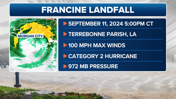
Hurricane Francine landfall on Wednesday, Sept. 11, 2024.
(FOX Weather)
WATCH: HURRICANE FRANCINE'S FURY SLAMS LOUISIANA WITH FEROCIOUS WIND, TORRENTIAL RAIN
The Category 2 hurricane made landfall south of Morgan City, Louisiana, with sustained winds around 100 mph, but soon weakened into a minimal hurricane by Wednesday evening as it moved over Louisiana, dropping to tropical storm status on Wednesday night. However, the storm was still bringing torrential rains and powerful winds.
Nearly 300,000 electrical outages were reported within the first hours after the storm as gusts hit 97 mph in Dulac and 78 mph in New Orleans. Authorities have warned residents to stay indoors due to the danger for first responders.
Video taken from the coastline showed several feet of storm surge inundating low-lying areas both before and during the hurricane. It was at least the seventh Category 2 or stronger event to make landfall in Louisiana since 2000.
Nearly 10 million residents in Louisiana and nearby states were under Flood Watches ahead of Francine’s arrival. The hazardous weather is also expected to impact Mississippi, Alabama, Florida, Tennessee and Arkansas before the storm system dissipates over the mid-Mississippi Valley.

Watch: Hurricane Francine pushes water, waves onto shore near New Orleans
Winds whip and help churn up waves in the town of Cocodrie, which lies southwest of New Orleans. Sept. 11, 2024.
WHAT'S NEXT FOR FRANCINE AS IT HEADS FOR MISSISSIPPI VALLEY
Louisiana Governor Jeff Landry issued a state of emergency on Monday ahead of the cyclone, and President Joe Biden quickly followed with a disaster declaration, allowing FEMA to assist parishes directly in the storm’s path.
"Urban Search and Rescue teams are prepared to respond as needed, and FEMA has pre-positioned water, meals, generators, and other supplies in regional distribution centers," the agency announced in the hours leading up to landfall.
Authorities have not yet reported any injuries or missing persons from the event but warn it could be days before they are able to survey the damage across the region.

Storm surge overtakes Louisiana marina
Terrebonne Parish saw several feet of storm surge ahead of the arrival of Hurricane Francine on Wednesday.