Unlucky number 13: Francine the latest hurricane to strike the Louisiana coastline since 2000
Hurricane Francine made landfall south of Morgan City, Louisiana, as a Category 2 cyclone, becoming the 13th hurricane to make landfall in the state since 2000.

Hurricane Francine triggers Flash Flood Emergency for New Orleans
Life-threatening flooding was likely in New Orleans and communities west along Interstate 10 Wednesday night as the core of Hurricane Francine moved over the region, dropping multiple inches of rain in just hours.
A state renowned for its cultural and natural scenery is once again picking up the pieces after yet another bout with a landfalling hurricane.
Hurricane Francine made landfall south of Morgan City, Louisiana, as a Category 2 cyclone, becoming the 13th hurricane to make landfall in the state since 2000.
Francine knocked out power to more than 400,000 customers and flooded low-lying areas south of Interstate 10.
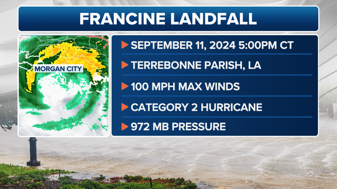
Hurricane Francine landfall on Wednesday, Sept. 11, 2024.
(FOX Weather)
The Category 2 hurricane produced damage figures that could reach upwards of $1.5 billion along the Gulf Coast, according to CoreLogic, a global technology company.
"CoreLogic Hazard HQ Command Central estimated Hurricane Francine insured wind and storm surge losses to be up to $1.5 billion," the company stated on Thursday. "Losses include damage to buildings, contents, and business interruption for residential, commercial, industrial and agricultural property. The vast majority of the modeled losses stem from damage in Louisiana with Mississippi and Alabama contributing slightly."
WHEN IS THE TYPICAL LAST HURRICANE STRIKE ON THE US COAST?
Francine’s landfall also made it the third hurricane to directly strike the U.S. in 2024, with other cyclones making landfalls in Texas and Florida.
Hurricane Beryl made landfall near Matagorda, Texas, on July 8 as a Category 1 cyclone and about a month later, Hurricane Debby strengthened into a Category 1 before making landfall near Steinhatchee, Florida, on Aug. 5.
Both events have been characterized by insurance companies as billion-dollar disasters, with Beryl being the costliest cyclone of the year, causing an estimated $6 billion in damage in the U.S.
Fortunately, for much of the western and central Gulf, the same patterns that work to their disadvantage earlier in the season begin to work in their favor starting in October, limiting the direct impacts of storms and how far they work westward.
The latest date Texas has been hit by a hurricane is Oct. 16, while Louisiana’s record stands at Oct. 29.
Although hurricane season runs through Nov. 30, states further downstream, such as Florida and the Carolinas, often experience more storms during the latter weeks of the season, giving the more western states a break.
What’s behind the recent uptick in strikes in Louisiana?
Forecasters say there is not one element that is behind the strikes in the state versus the uptick just being a stroke of luck.
The warm waters of the Gulf of Mexico increase the likelihood of hurricane formation, but the paths these systems take are influenced by various atmospheric features such as troughs, ridges of high-pressure and the jet stream.
This means that some regions are more vulnerable than others, but impacts can fluctuate from year to year.
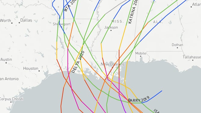
Hurricane strikes on the Louisiana coastline since 2000
(FOX Weather)
For example, in 2004, Louisiana experienced no hurricanes, while Florida was significantly impacted by four notable cyclones.
The atmospheric patterns that year favored tropical cyclones in Florida, largely sparing areas further west.

Hurricane Francine brings churning storm surge to Waveland, Mississippi
Hurricane Francine's storm surge brought rising waters and powerful waves to Waveland, Mississippi Wednesday night. (Video courtesy: FOX Weather Storm Tracker Mark Sudduth)
Similar patterns have been observed involving coastal regions of Texas and the Carolinas, where areas might experience multiple tropical cyclones followed by periods of reduced activity.
Louisiana’s terrain increases its vulnerability to tropical cyclones, with approximately 40% of the state being below sea level.
Although efforts such as coastal restoration programs and levee systems have been implemented to mitigate the hazards posed by hurricanes, measures are not infallible.