Pacific Northwest pounded by hurricane-force wind gusts, flooding rain from powerful atmospheric river storms
Forecasters say areas of locally heavy rain and higher-elevation mountain snow will continue Tuesday across the Pacific Northwest eastward to the northern Rockies as the storm begins to wind down.

Northwest slammed by powerful atmospheric river storm
Widespread power outages and flooding have been reported across the Pacific Northwest as a powerful atmospheric river storm slammed the region on Monday and Tuesday. FOX Weather Meteorologists Ari Sarsalari and Marissa Torres have the latest.
SEATTLE – The third powerful atmospheric river storm to impact the Pacific Northwest since the end of last week blasted portions of Washington and Oregon with hurricane-force wind gusts and torrential rain that led to widespread power outages, flooding and even Tornado Warnings.
The multiday threat began over the weekend when the region was impacted by rain in the lower elevations while snow fell in the mountains, raising the risk of avalanches.

Watch: Torrential rain pounds windows in Washington State
A video shared from Skagit County, Washington, shows heavy rain pelting windows on Monday night as a powerful atmospheric river storm lashed the Pacific Northwest.
After a brief pause in the action early Monday, another powerful storm swooped in and brought additional rounds of heavy rain and strong winds to cities like Seattle and Portland, Oregon.
That storm, according to the FOX Forecast Center, will continue to impact the region through at least the first half of the day on Tuesday before the system moves out by Tuesday afternoon and evening.
Photos and videos from communities across the Northwest provided a dramatic look at how the storm was impacting the region.
DOWNLOAD THE FREE FOX WEATHER APP

Watch: Vivid lightning illuminates sky above Bothell, Washington
A video shared from Bothell, Washington, shows bright flashes of lightning illuminating the sky on Monday, Feb. 24, 2025.
One video shared from Bothell, Washington, showed vivid lightning illuminating the night sky, while a loud rumble of thunder could be heard moments later.
Another video shared from Seattle showed heavy rain that appeared to be falling sideways due to strong winds that were reported in the area.
DEBUNKING 7 MYTHS ABOUT LIGHTNING

Watch: 'Sideways rain' falls in Seattle
A video shared from Seattle shows rain that appears to be falling sideways due to strong winds as an atmospheric river storm slammed the region on Monday, Feb. 24, 2025.
According to the Seattle Fire Department, whipping winds caused a tree to topple onto a vehicle on Monday, trapping three people inside.
Officials said power lines were also brought down, and crews were able to successfully remove the victims from the car. All three were reported to be in stable condition.
HOW PUBLIC SAFETY OFFICIALS NOTIFY YOU DURING SEVERE WEATHER EMERGENCIES

Watch: Car crushed by tree brought down in Seattle during powerful atmospheric river storm
FOX 13 Seattle shared video of a car that was crushed by a tree that fell during a powerful atmospheric river storm on Monday, Feb. 24, 2025.
A similar incident took place in the community of Granite Falls to the northeast of Everett, Washington.
According to Snohomish Regional Fire and Rescue, a tree fell onto a vehicle, trapping the driver inside. First responders were able to safely remove the driver from the vehicle.
"During a windstorm, avoid unnecessary driving," officials said on X. "Ground is saturated compromising the roots of trees."
Power outages are starting to drop after skyrocketing to more than 160,000 early Tuesday morning. Oregon, too, is seeing power outages drop after more than 52,000 outages during the morning hours, according to FindEnergy.com.

Powerful wind gust tosses furniture in Seattle yard
Security footage at the home of Mark DeLoura captured a gust of wind dragging his covered outdoor furniture and scattering it around his yard early Tuesday morning. He said the bubble structure had been in place for five years and was heavily weighed down.
Another video recorded in Seattle shows how the strong wind gusts drag outdoor furniture and scatter it across a yard.
"There was a tall arch trellis there where it wound up, for growing beans and peas and tomatoes: now wiped out," Mark DeLoura wrote on X. "I think at least ten feet of it pulled out of the ground."
WHAT TO DO IF A TREE FALLS ON YOUR HOUSE
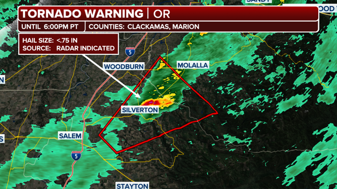
This graphic shows information on a Tornado Warning issued in Oregon on Monday, Feb. 24, 2025.
(FOX Weather)
Tornado Warnings were also issued south of the Portland area in Oregon on Monday evening.
The Tornado Warnings were issued for Clackamas and Marion counties, and it was the state’s first Tornado Warning in three months.
They were also the first Tornado Warnings in Oregon to be issued in the month of February since at least 1991.
THIS IS THE LIFE CYCLE OF A TORNADO
![]() Image 1 of 6
Image 1 of 6Images from Washington State Department of Transportation showing flooding on US 2 west of Fairchild Air Force Base on Sunday, Feb. 23, 2025. (@WSDOT_East/X)
![Images shared by the Washington State Department of Transportation show flooding in Whitman County on Sunday, Feb. 23, 2025.]() Image 2 of 6
Image 2 of 6Images shared by the Washington State Department of Transportation show flooding in Whitman County on Sunday, Feb. 23, 2025. (@WSDOT_East/X)
![Images shared by the Washington State Department of Transportation show flooding in Whitman County on Sunday, Feb. 23, 2025.]() Image 3 of 6
Image 3 of 6Images shared by the Washington State Department of Transportation show flooding in Whitman County on Sunday, Feb. 23, 2025. (@WSDOT_East/X)
![Images shared by the Washington State Department of Transportation show flooding in Whitman County on Sunday, Feb. 23, 2025.]() Image 4 of 6
Image 4 of 6Images shared by the Washington State Department of Transportation show flooding in Whitman County on Sunday, Feb. 23, 2025. (@WSDOT_East/X)
![Images shared by the Washington State Department of Transportation show flooding in Whitman County on Sunday, Feb. 23, 2025.]() Image 5 of 6
Image 5 of 6Images shared by the Washington State Department of Transportation show flooding in Whitman County on Sunday, Feb. 23, 2025. (@WSDOT_East/X)
![Images shared by the Washington State Department of Transportation show flooding in Whitman County on Sunday, Feb. 23, 2025.]() Image 6 of 6
Image 6 of 6Images shared by the Washington State Department of Transportation show flooding in Whitman County on Sunday, Feb. 23, 2025. (@WSDOT_East/X)
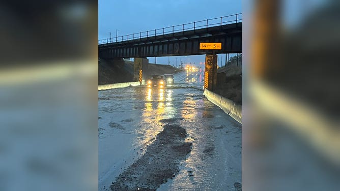

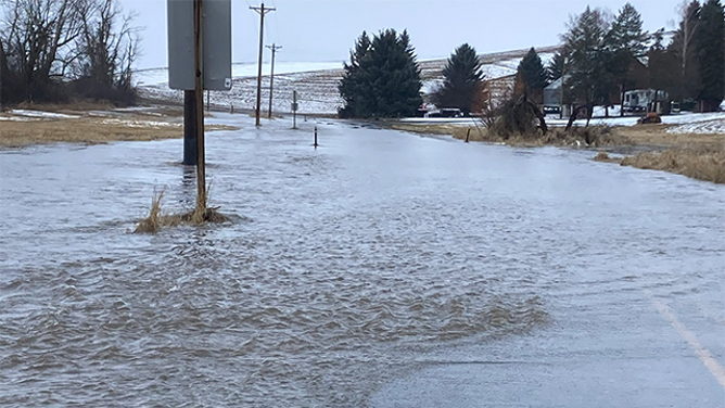


Over the weekend, the Washington State Department of Transportation shared photos of street flooding that was reported in Whitman County in the eastern part of the state along the Idaho state border.
Communities up and down the Interstate 5 corridor from the U.S.-Canada border through Oregon were told to prepare for potential flooding, power outages and mountain snow as the storms slammed the region.
PLAN, PREPARE, PROTECT: HOW TO BEST COVER YOUR PROPERTY AGAINST FLOODS
Storm to start winding down on Tuesday

(FOX Weather)
Forecasters say areas of locally heavy rain and higher-elevation mountain snow will continue Tuesday across the Pacific Northwest eastward to the northern Rockies as the storm begins to wind down.
The National Weather Service said a cold front will move through the region, bringing an end to the precipitation, with most rain ending by Tuesday evening and high-elevation snow lingering into Wednesday morning.
HOW HEAVY IS IT REALLY GOING TO RAIN?

(FOX Weather)
Wind alerts are in effect across the region, including High Wind Warnings for portions of Washington, Oregon and Montana.
"Damaging winds will blow down trees and power lines," forecasters at the NWS office in Seattle said. "Widespread power outages are expected. Travel will be difficult, especially for high-profile vehicles."
Forecasters are advising people to avoid being outdoors in forested areas or around trees and branches, and to remain in the lower level of homes.
(FOX Weather)
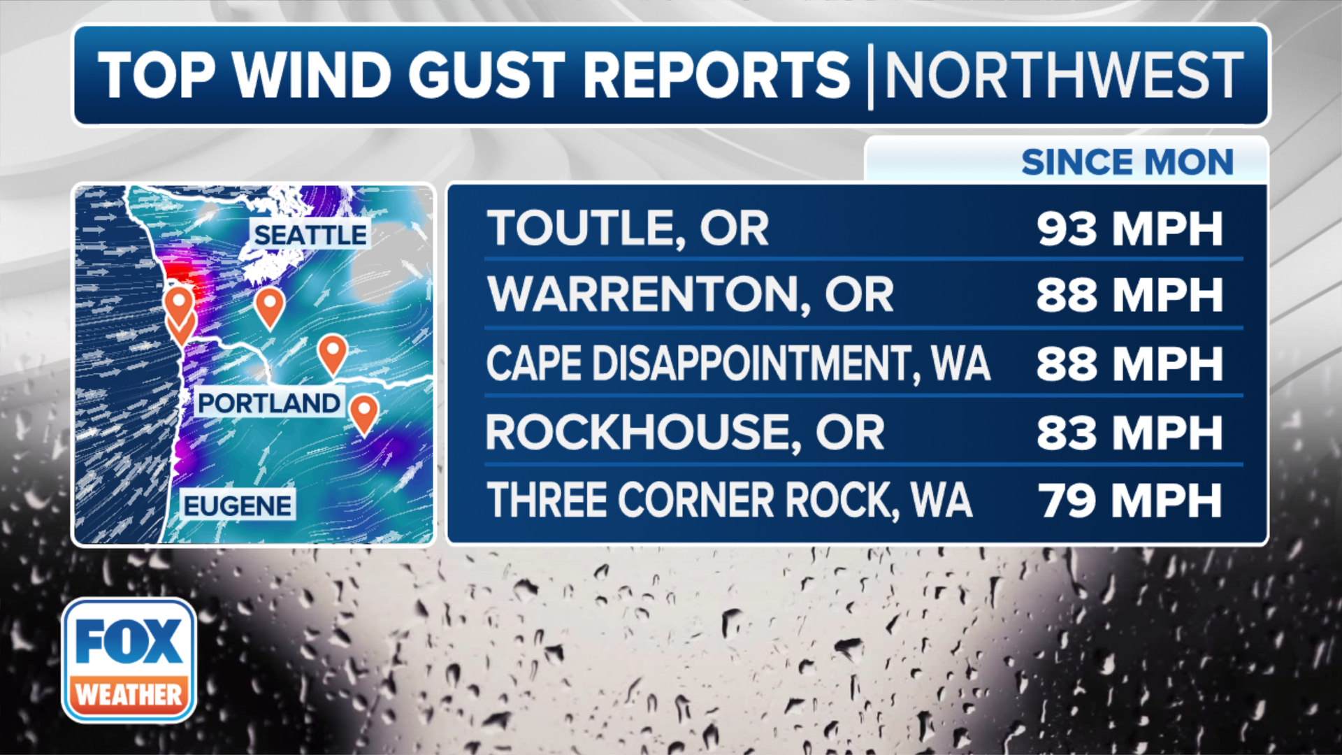
The winds have been whipping across the region, including hurricane-force wind gusts in Washington and Oregon.
The community of Toutle, Oregon, was blasted by a 93-mph wind gust, which is as strong as a Category 1 hurricane. Both Warrenton, Oregon and Cape Disappointment, Washington, reported wind gusts of 88 mph.
Seattle-Tacoma International Airport experienced its second-highest February wind gust on record at 52 mph. That's just 1 mph shy of its record of 53 mph.